Glen Ogle Trail
View Photos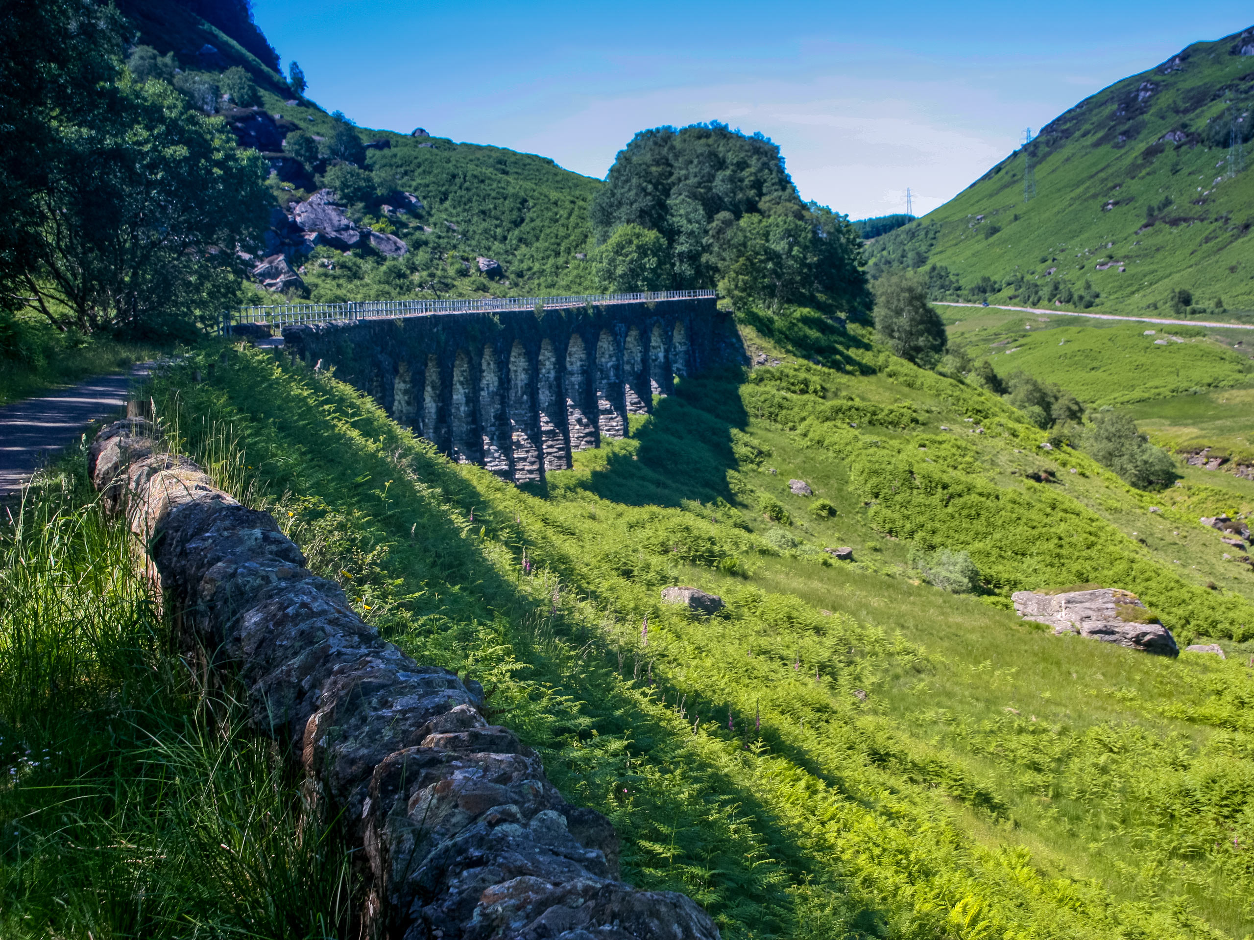
Glen Ogle Trail
Difficulty Rating:
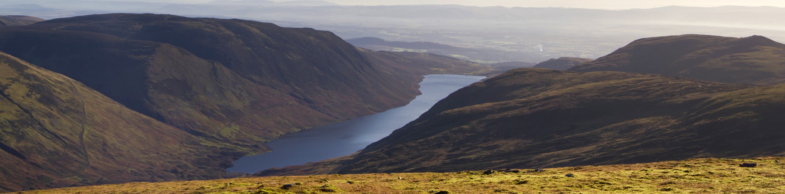
The Glen Ogle Trail is a brilliant walk beginning in the tiny village of Lochearnhead in Stirling, Scotland. The walk features undulating hills with a mix of gentle and moderate climbs and boasts an array of forest and burn scenery as you walk through the glen. Sections of the trail invite you to follow an abandoned railway line and an old military road peppered with ancient stone bridges.
Getting there
To get to the Glen Ogle Trail, head to the parking lot on the A85, across from the Watersports Centre in the village of Lochearnhead. Park here, then head out along the A85 towards the village center, keeping an eye out for the town hall on your right, then navigating a footbridge suspended over the Ogle Burn. Arrive at the A84 junction then cross the road and take a right, walking beneath the railway line to St Fillans. Look out for signs for Scout Station, heading left up the path while keeping your eyes peeled for a small path on the right with signs for Glen Ogle Trail.

About
| When to do | Year-Round Access |
| Backcountry Campsites | Loch Tay Highland Lodges |
| Pets allowed | Yes |
| Family friendly | Older Children only |
| Route Signage | Average |
| Crowd Levels | Moderate |
| Route Type | Lollipop |
Glen Ogle Trail
Elevation Graph
Weather
Glen Ogle Trail Description
The Glen Ogle Trail sets out from the tiny village of Lochearnhead, which lies within the Loch Lomond and The Trossachs National Park. The waymarked path leads through Glen Ogle, high above the belly of the glen itself, affording brilliant views. The trail unfolds on a good-quality cycle path to begin, requiring a steep climb to reach it. Later sections feature a track alongside an aged military road that is rough, boggy, and not as well marked as earlier sections. Proper footwear is a must on this trail, as well as a willingness to break a little sweat!
The Glen Ogle Walk is a great place to spend an afternoon in Scotland’s southern highlands, with the convenient option of popping into a local pub in the village of Lochearnhead for a post-walk pint or meal, following the walk. The trail packs the perfect combination of nature and history with the remarkable scenery of the steeply walled glen, the intriguing sections on the former Callander and Oban Railway, and an old military road constructed under Major Caulfield, which dates to 1749.
Pick up The Glen Ogle path by setting out from the car park off the A85 in Lochearnhead, following signs for Scout Station, then locating the signage for Glen Ogle Trail. From the trailhead, you’ll jump right into a steep climb ahead, soon passing through a kissing gate before making your way uphill to the old railway line. Keep an eye out as you begin to emerge from the dense forest, looking for the cycle path flanked by trees, which will then lead you along the old railway line, heading right.
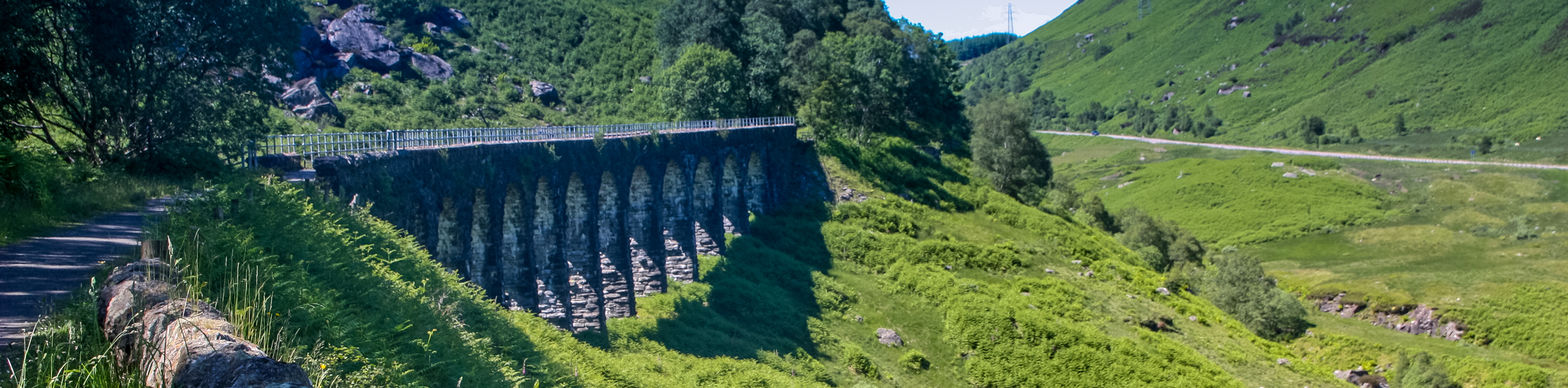
Enjoy a section of gentle climbs, making sure to pause and look back on the views of Lochearnhead village from this vantage point. The trail continues along the railway line leading you past several pretty burns and a few cattle grids. The route will soon have you crossing the colossal 150-year-old Glen Ogle Viaduct, comprised of 12 impressive stone arches.
The rail line continues to guide your path as you look out for the sign for the “Old Military Road” and an accompanying stile on the right. Crossing the stile marks your venture into rougher territory, as the trail going forward is boggy and less well-marked. Press on through the bracken, navigating a small wooden bridge before continuing the path downhill. You’ll soon find the old military road mirroring the Glen Ogle path and a series of several old stone bridges marking the way.
The next stage of the trail has you heading back down the glen through a muddy land-slipped area that requires caution when traversing. Follow the waymarkers that lead you through a section of trees, and you’ll note the path soon becomes drier and better-marked as you walk alongside the burn.
Continue the trail, climbing towards the main road before briefly heading right to cross the road and pick up the far side path. Spot the marker posts and take the course, which turns right, leading you through a section of grasslands and boggy woods. Once you reach a stile, pass through, and set out across a wide-open field towards another stile, you’ll find standing opposite. Pass through the second stile continuing the path left to the corner, then right, which takes you over a burn. Walk the path that carpets the undulating grassy slopes, using the marker posts to keep you on track. You’ll then climb through a sizable gap in a stone wall before continuing through a gate.
With your sights set on the large barn on the left, press on down the glen crossing a burn before following the telegraph poles through the field above the burn. Headed diagonally left, you’ll walk the light path through a grassy field until you reach a post where the trail slopes downhill. Pass through a gate, then head for the stile in the far corner, which has you crossing into pretty woods. The final stretch guides you through the trees before crossing another burn and taking the footbridge suspended above the river. On the far side after crossing, head left, passing through the pedestrian gate into a field where you’ll likely spot cattle. Veer left in the field to join the path, leading to a final kissing gate ushering you back to the main road. Head left on the road, retracing your steps from the first section, walking under the railway bridge and taking a left at the road junction, returning to the car park in Lochearnhead where the trail began.
Insider Hints
The car park in Lochearnhead off the A85 has toilets you can use at the beginning or end of the walk
You can reach Lochearnhead by public bus as an alternative to driving
Lochearnhead boasts several cozy pubs, perfect for a pint and a meal after the walk
Similar hikes to the Glen Ogle Trail hike
Big Tree Walk
The Big Tree Walk is a lovely 1.6mi, waymarked forest trail beside the Benmore Botanic Gardens. The route…
Arrochar Caves Walk
The Arrochar Caves Walk, found in Arrochar, UK, is a 2.8mi trail that leads through a scenic forest,…
Ben Chonzie Walk
The Ben Chonzie walk invites hillwalkers to venture up the highest summit in the immediate area to reach an exciting…
Comments