Wastwater Extended Loop
View Photos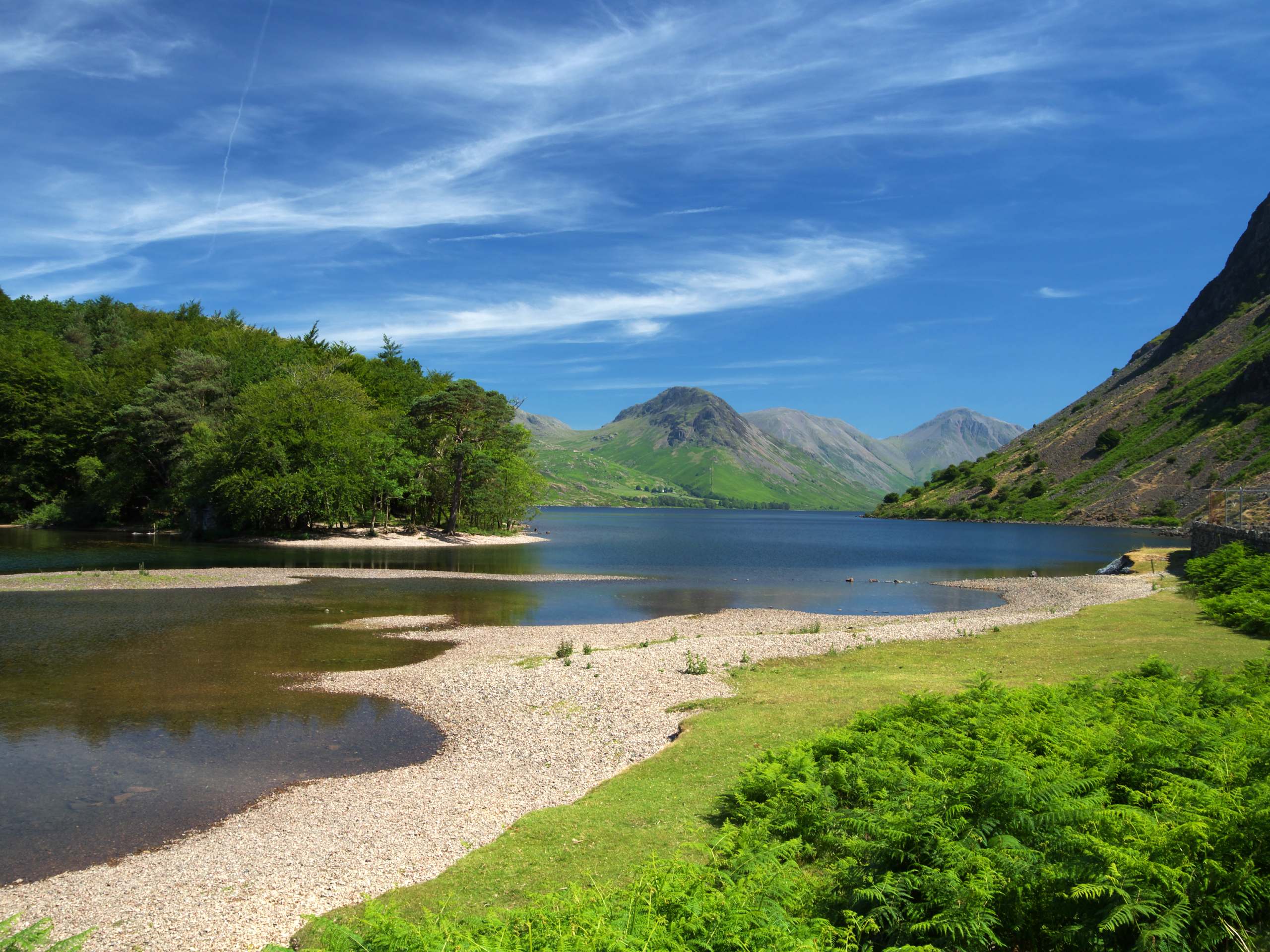
Wastwater Extended Loop
Difficulty Rating:
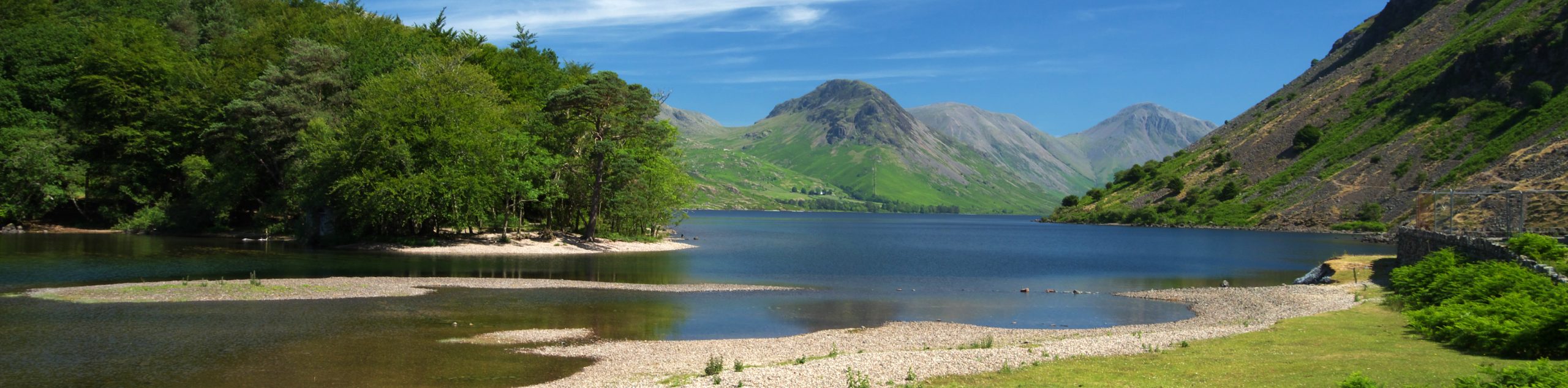
The Wastwater Extended Loop is an easy-going walking route in the Lake DIstrict that will take you through the picturesque terrain of Wasdale for some elevated views of Wastwater. While out on the trail, you will trek through beautiful stretches of open farmland and serene forests before traversing the terrain along the foot of Whin Rigg on the way to the edge of the lake. This route features a small amount of elevation gain, but it is easy enough for walkers of most skill levels to complete.
Getting there
To reach the trailhead for the Wastwater Extended Loop from Gosforth, drive east on Wasdale Road for 0.6mi and make a slight right onto Leagate Brow, following it for 0.2mi. Here, the road will turn slightly right to become Lane Side. Follow this for 2.0mi and turn right, continuing on for another 0.6mi. Make another right here and follow the road for 0.4mi before turning left to arrive at the trailhead.

About
| When to do | Marc-November |
| Backcountry Campsites | Church Stile Farm and Holiday Park |
| Pets allowed | Yes - On Leash |
| Family friendly | Older Children only |
| Route Signage | Average |
| Crowd Levels | Moderate |
| Route Type | Circuit |
Wastwater Extended Loop
Elevation Graph
Weather
Wastwater Extended Loop Description
Walking the Wastwater Extended Loop is a fun adventure that will take you through a good variety of terrain that features some small elevation gains. Make sure to wear proper walking boots for this adventure to stay comfortable on the trail. If you are travelling with a dog, make sure to put them on a leash for any portions of the walk, where livestock might be present.
This walk is perfect for a casual weekend stroll outdoors due to the picturesque scenery and variety of terrain that keeps things interesting. While out on the walk, you will pass through stretches of farmland, rugged hillsides, and serene woodlands before arriving at the edge of Wastwater. In addition to the amazing views across the lake, the mountainous surroundings create a gorgeous backdrop, with England’s highest peak, Scafell Pike, standing proudly in the distance. Pair this walk with a weekend of camping to get the most out of the experience.
Setting out from the trailhead in Nether Wasdale, head south along the road for a short distance and turn left, following it for 0.2mi to reach an intersection. Turn right here and continue south along the road for another 0.1mi to pick up the trail on the left. Pass through the gate and make your way past the building, following the trail for 0.2mi to cross over a stile and arrive at a small body of water known as Flass Tarn.
From here, continue to the south east, as the trail enters into a serene stretch of woodland terrain. Keep left along the path for the next 0.8mi to make your way along the edge of the wood before exiting the tree cover and arriving at a junction in the trail below the rocky terrain of Kilnhow Crag. Go right at the fork and keep right for the next 0.4mi to reach a junction just after crossing Greathall Gill.
At the junction, turn left and continue straight for 0.4mi to descend the hillside and pass through several gates, eventually arriving at a bridge crossing over the River Irt. Turn right and cross over the flowing water, making sure to keep right along the path for 0.6mi to skirt along the scenic edge of Wastwater with the thick green canopy of Low Wood on your left.
After taking in the views across the deep blue expanse of the lake with the majestic sight of Scafell Pike off in the distance, turn back and retrace your steps for 0.2mi, turning right to break away from the edge of the water. Turn right at the junction next to the YHA Wasdale Hall and continue on for 0.9mi to skirt around the foot of High Birkhow, following the trail as it turns west and arrives at a junction.
From here, turn right and follow the trail for 0.2mi, passing through one gate and a marshy area to arrive at another junction. Turn left along the path, followed by a right at the next available trail to begin the final leg of the journey along the Wastwater Extended Loop. Make your way north through the open terrain for 0.4mi and when you reach a junction, keep left along the trail and follow it as it turns to the south. From here, you will traverse the last 0.7mi of the route that will take you through several gates and over a stile to pass through the holiday park and bring you back to the trailhead where you began the walk.
Trail Highlights
Wastwater
Located in Wasdale, a scenic valley in the western part of the Lake District, Wastwater is a glacial body of water that holds the distinction of being the deepest lake in England at 259ft. Surrounded by rugged mountain peaks in all directions, Wastwater offers access to a number of outdoor recreation activities on both water and land.
Scafell Pike
At an elevation of 3209ft, Scafell Pike is the highest and most prominent peak in England. Located in the western portion of the Lake District, the mountain is one of several high fells that form a horseshoe shape along with Slight Side, Esk Pike, Bowfell, and Long Top. It is also a part of the now inactive Scafells Volcano.
Frequently Asked Questions
Can you fish in Wastwater?
As long as you hold the correct permits, fishing is permissible on Wastwater. Common catches include Arctic Char, Trout, Eel, Ferrox, and also Salmon during the spawning season. Fishing can only be done from the shore and no live bait is permitted.
Can you swim in Wastwater?
Swimming is permissible in Wastwater, although you will need to exercise all precautions and ensure that you are a strong enough swimmer to do so.
Insider Hints
If travelling with dogs, make sure to keep them on leash in areas where livestock may be present.
Pair this walk with a weekend of camping at the Church Stile Farm and Holiday Park to make the most out of your adventure.
Pop into the Sawmill Wasdale near the beginning of the walk for some refreshments.
Similar hikes to the Wastwater Extended Loop hike

Osprey Viewpoint & Bassenthwaite Lake Walk
The Osprey Viewpoint & Bassenthwaite Lake Walk is a scenic Lake District adventure that will expose you to some beautiful…

Hawkshead, Wray Castle, and Windermere Walk
The Hawkshead, Wray Castle, and Windermere Walk is a fantastic journey that will lead you through some picturesque locations that…

Pike of Blisco and Crinkle Crags Walk
The Pike of Blisco and Crinkle Crags Trail is a challenging adventure that will see you climb several rugged peaks…
Comments