Loughrigg Fell Circular Walk
View Photos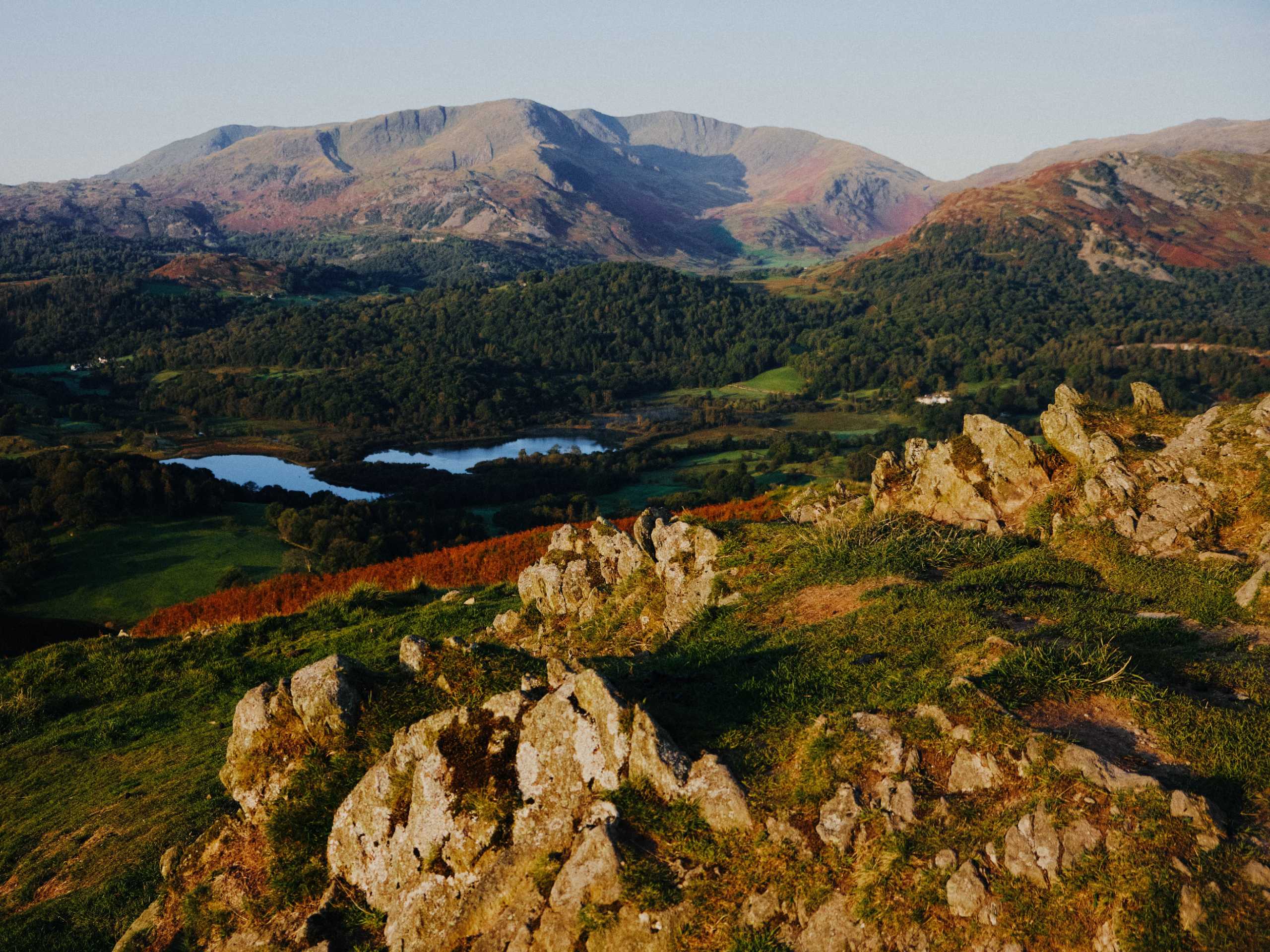
Loughrigg Fell Circular Walk
Difficulty Rating:
The Loughrigg Fell Circular is a 7.6mi walking circuit in the Lake District that will take you uphill along a rugged ridge for some amazing views across the Cumbria countryside. The trail sets out from Ambleside and takes you across the hilly terrain to summit the hill before skirting around the edge of Grasmere and Rydal Water to experience some beautiful scenery. Although the trail features some uphill walking to the summit, there are a series of steps that make the climb manageable for walkers of most skill levels.
Getting there
To reach the parking area for the Loughrigg Fell Circular Walk from the Ambleside Pier, drive northwest on Borrans Road for0.5mi and turn left onto the A593. After 0.1mi, turn left to stay on the road for another 120ft. Turn right onto Under Loughrigg and follow it for 0.3mi, where you will find several roadside parking spaces.

About
| When to do | Year-Round |
| Backcountry Campsites | Tarn Foot Farm Campsite |
| Pets allowed | Yes |
| Family friendly | Older Children only |
| Route Signage | Average |
| Crowd Levels | High |
| Route Type | Lollipop |
Loughrigg Fell Circular Walk
Elevation Graph
Weather
Loughrigg Fell Circular Walk Description
Walking the Loughrigg Fell Circular is a popular experience in the Lake District due to the stunning views and easy access to a number of other outdoor activities in the area. Because of this, the trail can become a bit busy during peak times, such as weekends and bank holidays. Be sure to arrive early enough to enjoy the trail without throngs of people, as well as to secure one of the limited parking spaces at the trailhead.
Additionally, the climb to the summit is relatively easy but may still pose a problem for less mobile walkers due to a number of steps. Come prepared with good walking boots and poles if you need them, and be sure to take your time to fully enjoy the amazing views!
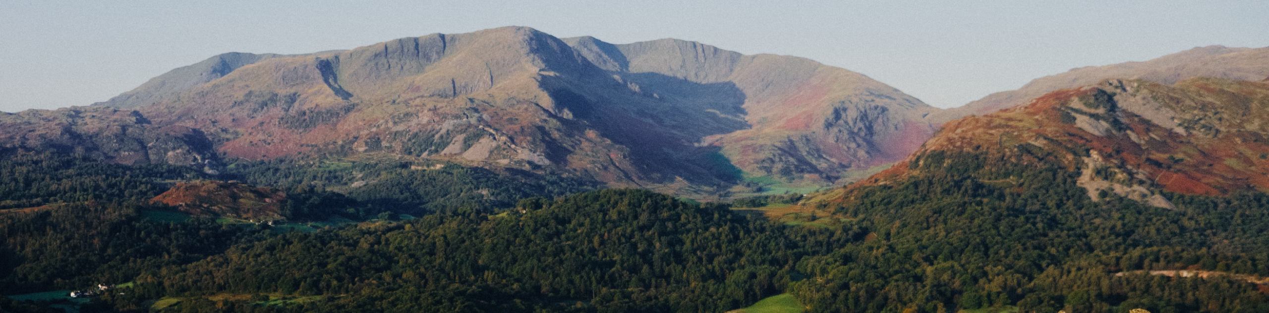
Although the trail will likely be busy, it won’t be so chaotic as to take away from the amazing experience of walking to the summit of Loughrigg Fell to take in the spectacular views. The trail sets out from the side of the River Rothay and climbs uphill to traverse the southern stretch of the ridge along Ivy Crag, before passing Loughrigg Tarn along the western slope of the hill. After climbing uphill to the summit for amazing views across the Lake District landscape, you will descend the hill and make your way along the edge of Grasmere and Rydal Water before turning south on the return to the trailhead. There will be no shortage of breathtaking views along this walk, so don’t forget to bring your camera!
Setting out from the roadside trailhead along the banks of the River Rothay, follow the road north for 1.2mi and head left at the fork. Keep straight along the lane for 38.0mi, where you will head through a stretch of forest and pass through a gate. Continue on to the west for another 0.6mi, as you climb uphill through the open terrain and pass through several more gates before arriving at a crossing over Troughton Gill. Make your way over the stream and head left at the fork to descend the hillside while enjoying some nice views overlooking Loughrigg Tarn below.
0.3mi after crossing Troughton Gill, you will pass through a gate and have the rocky outcrop of Ivy Crag on your right. Keep straight for the next 0.4mi, as you work around the foot of the hill and arrive at a junction in the trail next to the Tarn Foot Farm Campsite. Head right here and pass through the gate, making your way northwest to cross a series of stiles next to the tarn. After passing by the farm on your right, keep straight along the lane for the next 0.3mi until it meets up with the edge of the road.
Make your way north alongside the road for 0.4mi as it passes through an area of scattered woodland terrain, before branching off to the right on a gated path. Keep right along the path and pass through the kissing gate to cross over a stream, sticking to the path on the right to begin the ascent of Loughrigg Fell. As you make your way up the steep steps along the hillside, keep right at any junctions for the shortest route to the summit. Once there, you will have a breathtaking view of the surrounding terrain that includes Nab Scar, Grasmere, and Rydal Water to the north.
After taking in the views, carefully make your way back down the hillside and head right at the previous junction to arrive at Loughrigg Terrace. Here, you will experience a less-elevated view across the surface of Grasmere and Rydal Water, although it will be no less scenic. Continue east along the trail until you arrive at the edge of Rydal Water, where you will have a nice view overlooking Heron Island and Little Isle in the middle of the lake.
From here, continue east along the foot of the hill to pass through the tranquil atmosphere of Steps End Wood, before meeting up with the road near the Rydal Pelter Bridge Car Park. Follow the road for 0.1mi and turn right to continue along the road as it runs parallel to the River Rothay. From here, it is a 1.4mi walk along the winding road as it cuts through the picturesque English countryside and eventually arrives back at the trailhead where you began the Loughrigg Fell Circular walk.
2024 walking conditions at Loughrigg Fell
For 2024, hikers planning to visit Loughrigg Fell should prepare for typical Lake District weather, which can be unpredictable with chances of sudden rain and changes in temperature. Fog and mist can reduce visibility, especially during the morning and late evening. Trail conditions are generally good, but as with many popular hiking destinations, the paths can become muddy and slippery after rain.
Trail Highlights
Loughrigg Fell
Located in the central part of the Lake DIstrict, Loughrigg Fell is a 1099ft tall hill that overlooks a fair amount of open water, including the River Rothay, Grasmere, and Rydal Water. The trail surrounding the ridge offers access to a number of nearby outdoor activities, making it a popular recreation destination in the area.
Grasmere
One of the smaller lakes within the Lake District, Grasmere is a picturesque body of water that is surrounded by wooded slopes and fed by the River Rothay. The lake is the source of the name for the nearby village of Grasmere and is often named as a source of inspiration for English poet William Wordsworth.
Frequently Asked Questions
How long does it take to walk up Loughrigg Fell?
Walking along this route will likely take you 3-4 hours from the car park to the summit and back.
How hard is it to climb Loughrigg Fell?
The majority of this route is a fairly easy walk through the countryside; however, the uphill portion to reach the summit will provide a bit more difficulty, as you will gain roughly 180m of elevation along a series of steps up the rugged hillside.
Insider Hints
Arrive early to secure one of the few parking spaces at the trailhead
Pair this walk with a weekend of camping at the Tarn Foot Farm Campsite.
Visit the nearby Roman Fort in Ambleside to learn about the ancient history of the area.
While dogs are allowed along the trail, they will need to be on-leash at certain points due to the possibility of livestock in the area.
Similar hikes to the Loughrigg Fell Circular Walk hike

Osprey Viewpoint & Bassenthwaite Lake Walk
The Osprey Viewpoint & Bassenthwaite Lake Walk is a scenic Lake District adventure that will expose you to some beautiful…

Hawkshead, Wray Castle, and Windermere Walk
The Hawkshead, Wray Castle, and Windermere Walk is a fantastic journey that will lead you through some picturesque locations that…

Pike of Blisco and Crinkle Crags Walk
The Pike of Blisco and Crinkle Crags Trail is a challenging adventure that will see you climb several rugged peaks…
Comments