Helvellyn Walk
View Photos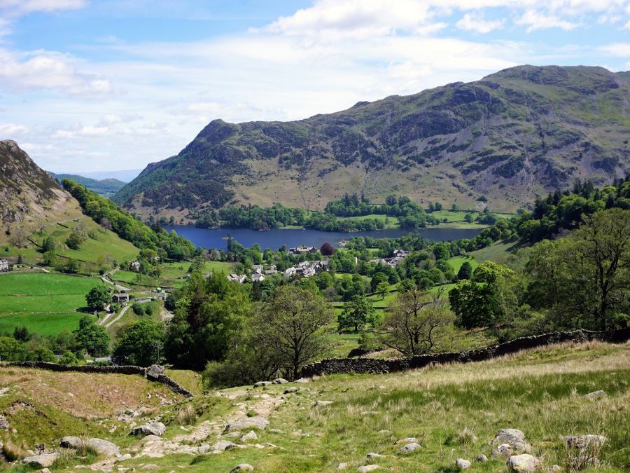
Helvellyn Walk
Difficulty Rating:
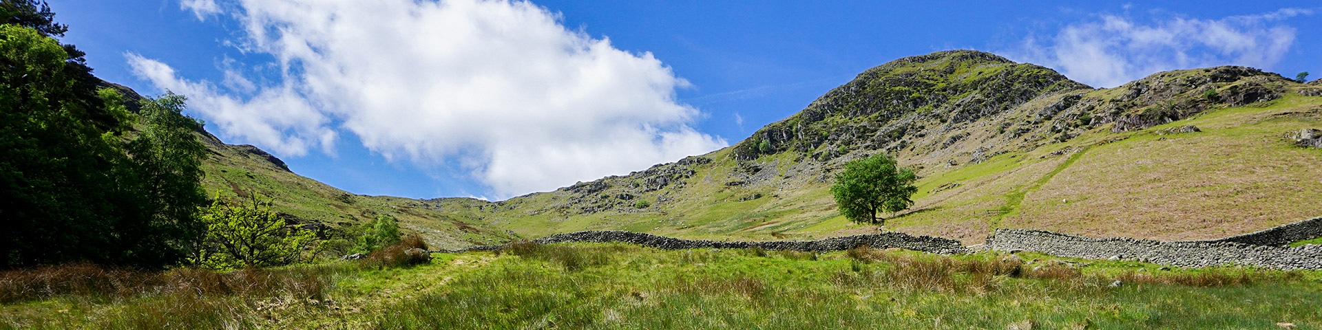
The Helvellyn walk is one of the classics in the beautiful Lake District. To complete this challenging walk, you will have to use your hands and to be comfortable with heights, but this route offers some of the best rewards in the Lakes. The ascent to Helvellyn will take you scrambling up the Striding Edge and to go down, you will descend the Swirral Edge. Helvellyn was named Britain's best walk in 2018!
Getting there
To get to the Helvellyn walk, make your way to the beautiful town of Glenridding and park in the main parking lot by the tourist information office. Parking is paid here, but there is good shade and a cafe near the parking lot if you need refreshment at the end of the walk.

About
| When to do | When Dry, no fog |
| Backcountry Campsites | None |
| Toilets | At Tourist Office |
| Family friendly | No |
| Route Signage | None |
| Crowd Levels | High |
| Route Type | Circuit |
Helvellyn Walk
Elevation Graph
Weather
Helvellyn Walk Route Description
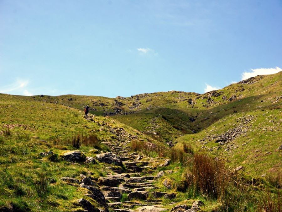
The classic Helvellyn walk starts from the Glenridding Tourist Information Centre. Ascend to the elevated section of the car park and take the path that goes to the right of NHS health centre. This takes you to a lane where you should turn left onto Greenside Road, heading uphill. You will soon pass the Travellers Rest pub, which is a good stop for a drink on the way back.
As you head uphill roughly 1427ft after starting, the road splits. Choose the left fork which is signed for Hillside Farm and not the tarmac lane going right, which is a private road to YHA Helvellyn. The Helvellyn walk trail passes over a bridge and continues uphill, then follows a rocky track leading off to the right along a stonewall.
When this path splits, take the path to the left, following signs to Helvellyn via Miresbeck, which is listed as 3.0mi. In 295ft the path reaches a stone wall where you should turn right on a broad path, continuing uphill before coming to another wall. Stay to the right of the stonewall and continue uphill.
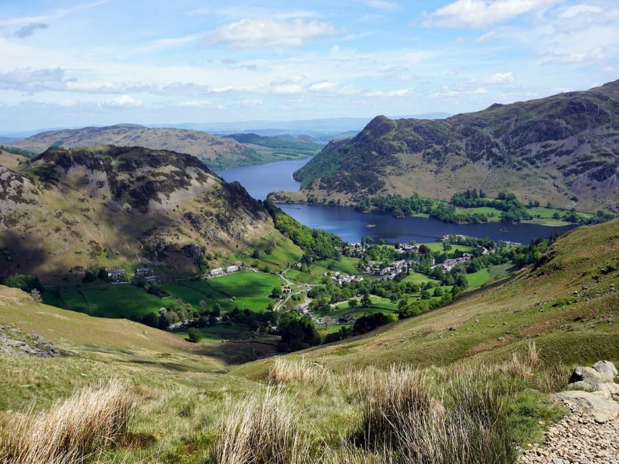
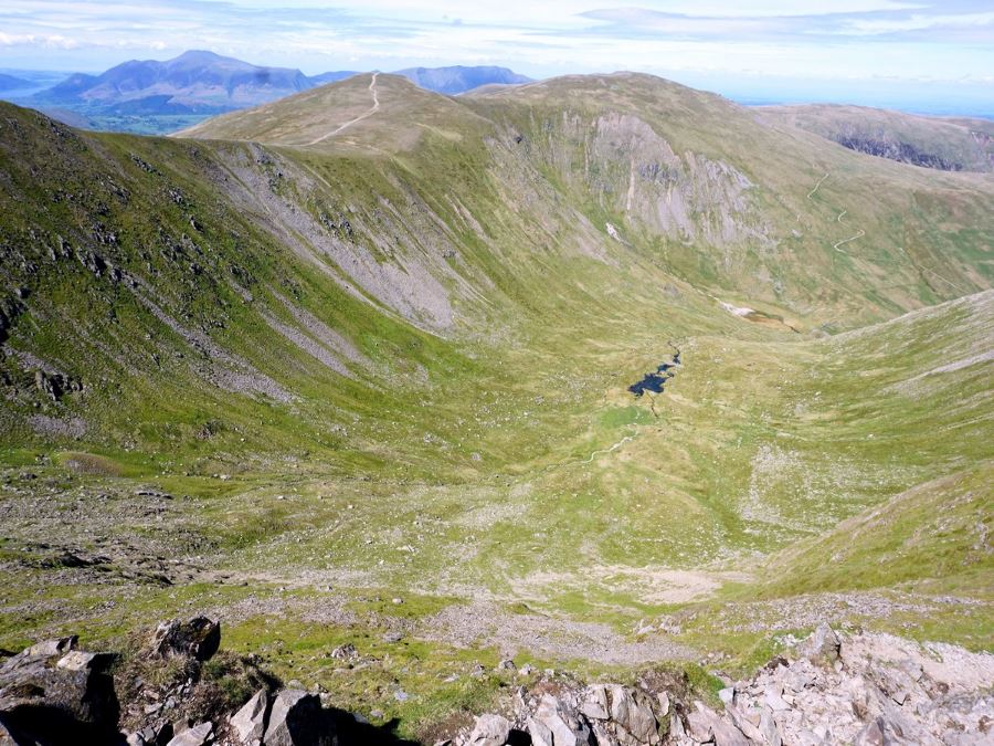
At 0.7mi from the start of the Helvellyn walk, go through a gate set in a stonewall and immediately go left. Very soon you’ll drop down to cross the small Mires Beck (stream) and then following the Mires Beck uphill. Look back for wonderful views of Glenridding and Ullswater. After passing the head of the stream the path curves around to the right, with a well-built stonewall on the left.
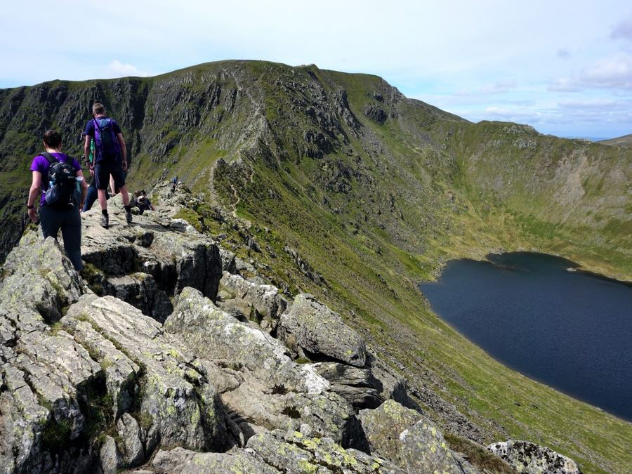
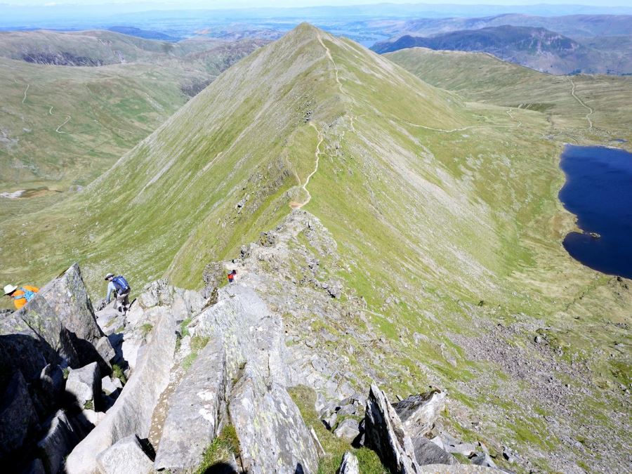
At 1.9mi, crest the hill you’ve been climbing and see Helvellyn ahead. Striding Edge is the ridge on the left and Swirral Edge, on the right, is the route you’ll come down. About 3002ft later the path splits. At this point, if you are uncomfortable with exposure and scrambling go to the right and past Red Tarn and then up to Helvellyn via Swirral Edge. Swirral Edge is steep and still requires using your hands, but it is easier than Striding Edge.
Hiking Helvellyn in Lake District in 2024
Hiking Helvellyn remains a popular adventure in 2024. With routes like Striding Edge and Swirral Edge offering exhilarating challenges, the 2024 hiking season will see variable weather with a high likelihood of unsettled conditions, including sunny spells interspersed with showers and possibly heavier rain at times. The early part of the season has seen better weather recently, particularly from March to June. However, as always in the Lake District, the weather can change rapidly, so it’s crucial to check daily forecasts before heading out.
As for crowds, the Lake District tends to be busier during weekends, bank holidays, and school holidays. If you’re looking for a quieter experience, it’s advisable to plan your hikes on weekdays. Starting early in the morning can also help you avoid the busiest times and secure parking more easily.
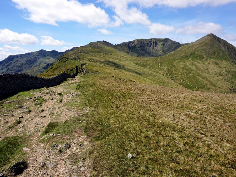
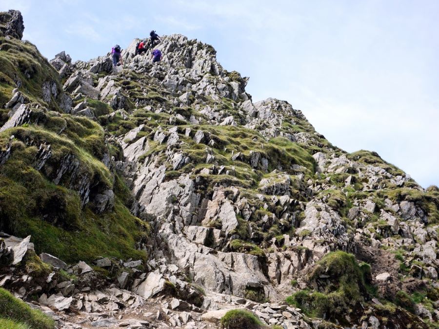
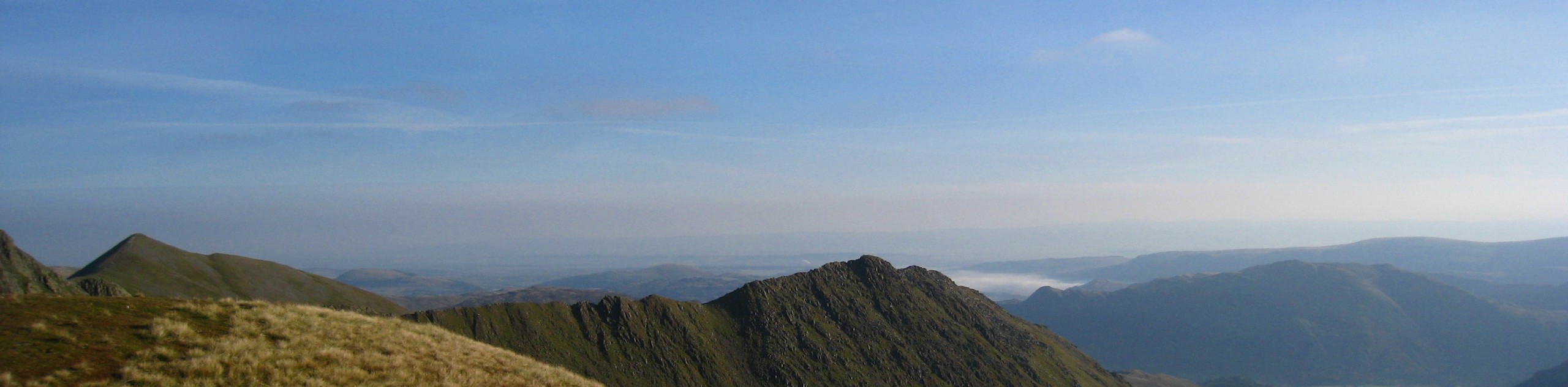
Helvellyn via Striding Edge
Most people go to Helvellyn via Striding Edge. You can see this path snaking up the left-hand ridge. From this angle, it doesn’t look too difficult.
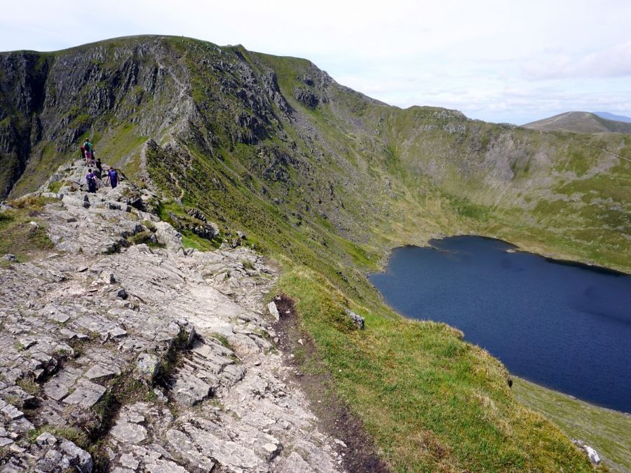
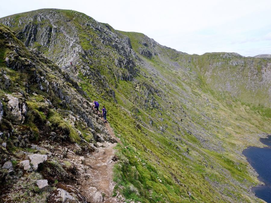
At 3.1mi from the trailhead you hit the Striding Edge ridge. If you would prefer an easier route, choose the path to the right. Note that this path is also exposed, though it doesn’t have the same degree of difficulty as the ridge. Our map shows part of the route on the ridge and part on the easier path on bypass below.
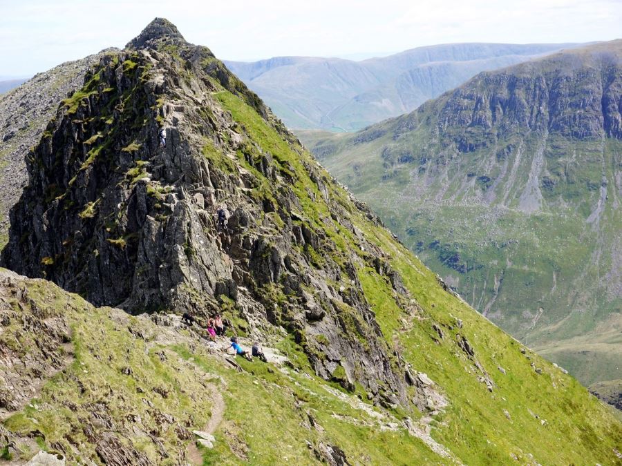
It’s worth noting that we regularly hear people telling their group that they are turning back from the ridge. This is an uncomfortable walk so if you or someone in your group decides this isn’t for you, nearby Red Tarn is a great place to take a break while others in the group continue.
At the end of the ridge there is a tricky section that you need to down-climb before the final push to the summit. There is no easy way to do this – some people go down on their bum and others choose to face in and down-climb this route. This is slow-going and if the trail is crowded, you may need to wait in line at this point.
While you have now passed the toughest part of Striding Edge, the final push to the summit is very steep and you will need to use your hands. Near the top, the path splits and you should continue to the right.
Swirral Edge
From the summit there are several options for getting down, however many people prefer to go down via Swirral Edge. Going down Swirral Edge is less strenuous than Striding Edge, but it is still not easy.
After going down Swirral Edge, at 4.3mi from start the path splits. We prefer to go left over Catsycam, however, you can also choose to go right for an easier way down in the valley, passing close to Red Tarn. From Red Tarn, continue on the lefthand path down the valley.
If you choose the route over Catsycam, you’ll also get nice views. From the top of Catsycam the path heads down to the right along a path that is less clear than the pathway up was. When you hit the main path go left and head down the valley.
Roughly a 1.0mi after getting on the main path, you’ll pass over a pair of bridges and continue on the trail. After 1509ft the path splits again. Here you can take either path as they re-join in a few minutes.
Soon afterwards you will notice a bridge on your left crossing Glenridding Beck. You can cross over this bridge if you are staying at YHA Helvellyn or want to walk on the road back to Glenridding, however, we prefer to stay on this side of the stream.
The path splits 591ft after the bridge. Take the lower path on the left, though if you take the upper path on the right, you will have an opportunity to rejoin the lower path later.
At 7.3mi from the start of the Helvellyn walk, you will rejoin the path you took at the start of the day at a gate in a stonewall. Go through the gate and downhill. In 755ft, pass another gate and continue downhill to the left. When you come to the road, turn left and go over a bridge.
At the next road, turn right and continue downhill to the car park. Remember to turn right at the NHS health centre. It takes around 6-7.5 hours to complete the Helvellyn walk via Striding Edge and Swirral Edge.
If you’re planning to do this hike, remember that the Helvellyn walk can be dangerous in bad weather conditions, so take extra care.
Walking route highlights
Helvellyn
Helvellyn is the highest mountain in the Helvellyn mountain range. It’s the third-highest point in the Lake District and in England (3117ft), after Scafell Pike (3209ft) and Sca Fell (3163ft).
Helvellyn was named England’s most popular fell-walk in 2018. On a clear day, you can see magnificent 360-degree panoramic views of the Lake District, all the way up to the Irish Sea.
Although wild camping in Lake District is illegal, there is a known tradition of people camping near the Red Tarn and even on the summit itself. This is often tolerated if no one stays more than one night.
Helvellyn is also a popular climbing destination in the winter. There are several great climbing routes at the steep headwall above Red Tarn.
Looking for more great walks in the Lake District? Check out the Scafell Pike Walk, Fairfield Horseshoe or the Old Man of Coniston.
Consider a Walking Holiday in the Lake District
One of the best ways to experience this stunning national park is by booking a pre-planned adventure tour in the Lake District. Find amazing guided and self-guided tours on 10Adventures Tours.
Insider Hints
You can get to Glenridding by taking the 508 Penrith to Windermere bus stops in Glenridding.
The Inn on the Lake is a beautiful hotel in Glenridding.
If you're looking for a great accommodation choice not far from the trail head, consider the Matson Ground Holiday Cottages. Their cosy rustic cottages have all the amenities and privacy you need for a relaxing stay after tackling Helvellyn.

Similar hikes to the Helvellyn Walk hike
Nethermost Pike via East Ridge Walk
Walking to Nethermost Pike via East Ridge is a tough climb up several rugged fells that will expose you to…

Hawkshead, Wray Castle, and Windermere Walk
The Hawkshead, Wray Castle, and Windermere Walk is a fantastic journey that will lead you through some picturesque locations that…

Pike of Blisco and Crinkle Crags Walk
The Pike of Blisco and Crinkle Crags Trail is a challenging adventure that will see you climb several rugged peaks…
linz 2 years ago
Wow I loved the combination of a beautiful Good Friday hike with an exciting scramble (Striding Edge is fantastic!) and, for me, a physical challenge. I am fairly fit, but not 'mountain fit'. I love an ascent but did wonder if I'd make it up after the first steep hike and not yet being at 'the hole in the wall', but I'd recommend really taking your time and plenty of breaks if you need to up to there, because it flattens out significantly after that (for a while!) Striding Edge was quite windy so I was cautious and used my hands quite a lot, but there are plenty of good handholds, I mostly felt safe. I loved the Chimney at the end of Striding Edge, for me as an ex-climber, it's definitely best facing the wall. Top tip for it all is making sure you have good footholds (and there are plenty the whole way). The sharp ascent after Striding Edge to the summit was physically demanding on my legs (which were tired from the first ascent) but enjoyable and what an achievement when I reached the (very windy) top. The descent via Swirral's Edge felt less enjoyable, mainly because going down always feels less secure to me. But then the path after the initial steep descent felt very gradual and was definitely one of my more favoured descents (my knees usually cause me a lot of pain due to my ITBs). And the path back to Glenridding was quite flat by the end, perhaps where I made up some time because I thought my descent down Swirral's Edge was sllooowwww!! I'd highly recommend it! Enjoy!!
LynSlater 3 years ago
Great walk, but not for the feint hearted! Striding Edge is quite scary in places
Josephmkavanagh 3 years ago
Excellent walk. Exceeded expectations and I'd been looking forward to this one for some time. In places the option to scramble the ridge is supplemented by a path down one side or the other which is good for those not keen on scrambling. But it's certainly not a manicured route in all places. Which is more to my taste anyway. I feel the time allowed is quite generous. I completed it in around 5 hours and I took lots of photos. I used the gpx file from here and I found it to be easy to follow and reasonably accurate. Sometimes it said I was off course when following the path but this will just have been a signal accuracy issue. Overall can't recommend enough
ljones1510 3 years ago
We did this last weekend, the weather conditions were perfect. The first couple of kilometres were physically demanding, but after that everything was worth it.
C_C_A17@yahoo.com 4 years ago
Was really good. A bit busy, but other than that it was perfect
unicorn_lady 4 years ago
I usually prefer short hikes. However, since Helvellyn Walk is in Britain's best walk in 2018, i just had to experience it. Fortunately, I wasn't disappointed at all. Although the hike was quite challenging for me, it was worth it. The view on top was breathtakingly spectacular! Helvellyn is a sight to behold. I highly recommend this hike.
Charliechoco 4 years ago
a good challenge. walk along the ridges on top for the scenic view.
Jameslove15 4 years ago
Took more effort than usual in this hike. However, the scenery of Helvellyn's peak must be one of the bests.
ShirleySyk 4 years ago
A challenging walk with the most fantastic views of the lakes
Squarepants11 4 years ago
I find this hike challenging but I enjoyed it a lot!