
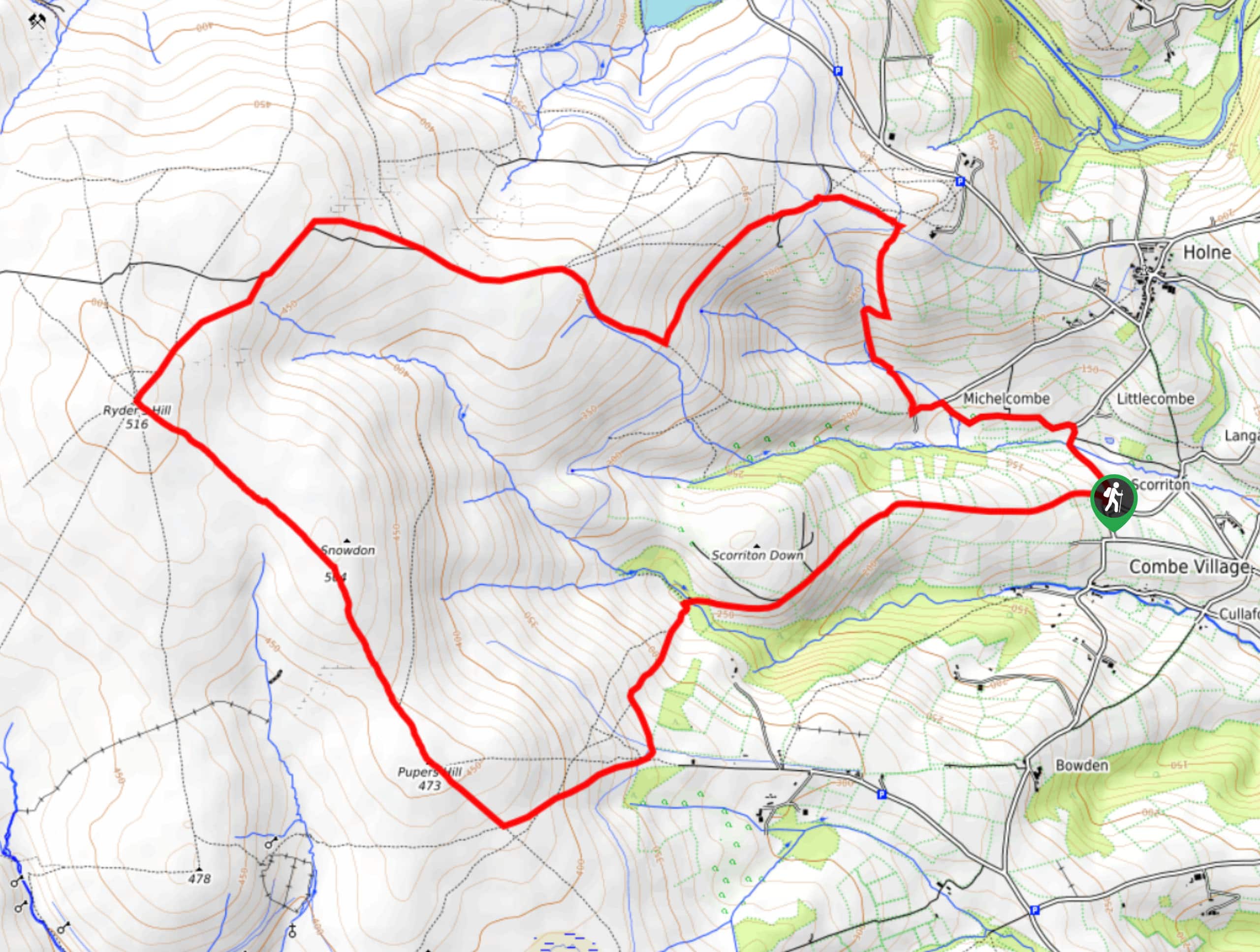
Ryder’s Hill, Snowdon, Pupers Hill, and Scorriton Down Walk
View Photos
Ryder’s Hill, Snowdon, Pupers Hill, and Scorriton Down Walk
Difficulty Rating:
Walking the Ryder’s Hill, Snowdon, Pupers Hill, and Scorriton Down trail is a wonderfully scenic journey that will expose you to some of the rugged terrain along the edge of Dartmoor National Park. While out on the trail, you will climb uphill across the rugged and barren landscape of the moor, taking in some gorgeous views of the surrounding area in the process. The route can be a bit wet and muddy in the spring or after a good rainfall, so be sure to check trail conditions prior to setting out.
Getting there
To reach the trailhead for the Ryder’s Hill, Snowdon, Pupers Hill, and Scorriton Down Walk from Buckfast, drive south on Higher Mill Lane for 0.3mi and turn right at Church Cross Road, following it for 0.7mi. Make a slight right onto Hockmoor Hill and continue on for 1.3mi, before making a slight left. After 0.4mi, turnright and follow the road for 0.1mi to arrive at the trailhead.

About
| Backcountry Campground | No |
| When to do | March-November |
| Pets allowed | Yes |
| Family friendly | Older Children only |
| Route Signage | Average |
| Crowd Levels | Moderate |
| Route Type | Circuit |
Ryder’s Hill, Snowdon, Pupers Hill, and Scorriton Down Walk
Elevation Graph
Weather
Ryder’s Hill, Snowdon, Pupers Hill, and Scorriton Down Walk Description
The Ryder’s Hill, Snowdon, Pupers Hill, and Scorriton Down Walk is a popular trail for walkers that enjoy traversing undulating terrain and those looking to experience the natural beauty of the moor. Setting out from the trailhead in Scorriton, you will make your way north past the Tradesman’s Arms and the church, following the road as it bends to the west and passes through Michelcombe. From here, you will climb uphill and traverse the rugged terrain of the moor to the west, eventually reaching the high-point of Ryder’s Hill. After taking in the sweeping views across Dartmoor National Park, follow the trail to the southeast to traverse Snowdon and Pupers Hill on the return to the trailhead.
Similar hikes to the Ryder’s Hill, Snowdon, Pupers Hill, and Scorriton Down Walk hike
Exmouth and Dawlish Warren Walk
Walking the Exmouth and Dawlish Warren Trail is a beautifully scenic but physically demanding excursion in Devon that will see…
Stoke Woods Circular Walk
The Stoke Woods Circular Walk is a quick and fairly easy adventure near Exeter that will expose you to some…
Ottery Saint Mary Woodland Walk
The Ottery Saint Mary Woodland Walk is a great excursion in Devon that features some relatively easy to manage terrain…
Comments