Morrone Walk
View Photos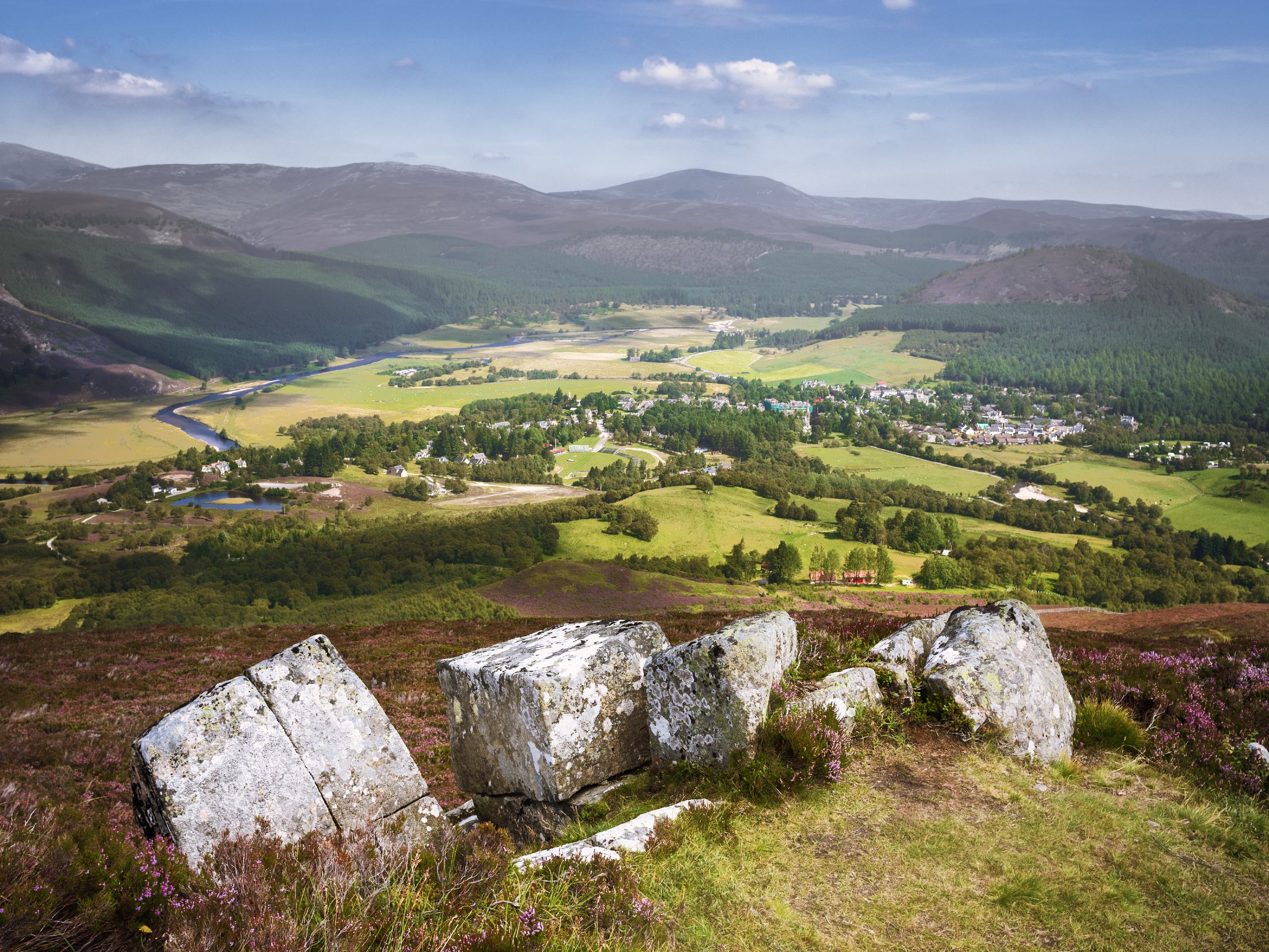
Morrone Walk
Difficulty Rating:
The Morrone Walk is a 7.5mi circular hillwalk located near Braemar, Scotland. This is the perfect way to soak up the incredible beauty of the Cairngorm peaks on a thrilling half-day excursion, and the views from the summit won’t disappoint! The return route features a lovely riverside stretch, providing the perfect cooldown following a relatively strenuous climb.
Getting there
To get to the Morrone Walk from the Braemar Castle, head west toward Old Military Rd/A93, then turn right onto Old Military Rd/A93. Continue for 0.5mi, then turn right onto Invercauld Rd/Old Military Rd. Soon after this, you’ll turn left onto Balnellan Rd and continue to the Balnellan Road Car Park on your left, where the walk begins.

About
| When to do | Year-round access |
| Backcountry Campsites | Braemar Caravan Club Site |
| Pets allowed | Yes |
| Family friendly | No |
| Route Signage | Average |
| Crowd Levels | Moderate |
| Route Type | Circuit |
Morrone Walk
Elevation Graph
Weather
Morrone Walk Description
The Morrone Walk invites hillwalkers to experience a fine Scottish Corbett in the Cairngorms National Park on a pleasant hillwalk that follows a combination of good paths, tracks and a minor road. The ascent is steep but easily navigable when weather conditions are favourable. If tackling this hill during the winter months, an ice-axe and crampons are recommended.
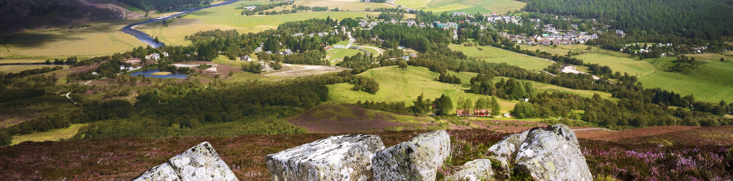
The Morrone Walk begins in the lovely village centre of Braemar, and from the summit of Morrone, views back down over Braemar from above are superb. The surrounding high Cairngorms seen from the summit will impress even the most seasoned hillwalker, and the riverside return route is also a nice touch!
To begin the walk, set out from the centre of Braemar and cross over the Clunie via the town bridge. Enjoy the views of the Clunie waterfalls as you continue on the main street, walking past the Fife Arms headed towards the Linn of Dee. Once the roundabout is reached, make a left and continue up Chapel Brae via the right-hand fork. You’ll then pass by some homes, a pond and a car park. After passing by the final house, follow signs for “Morrone” and keep left to follow the track.
At the next fork, keep left and pass through the gate to proceed uphill. As birch woods begin to appear in the near distance, bear right and continue to climb as the going gets steeper, veering left to enter the trees. At another fork, join the left path that continues to rise steeply uphill, and you’ll soon reach a bench with a viewpoint indicator. Spot the second sign for Moronne and continue across the track.
Press on as the route guides you further uphill to a point where you’ll reach another gate. Pass through the gate and enter to open moorland. The path continues uphill and is well-defined on this section, as views of Braemar, looking much like a toy-town from here, begin to open at your back. Once you spot several stone piles, you’ll know the mast on the top of Morrone will soon come into view. Stick to the path as it bends to the left and continues to ascend.
The Morrone summit is marked with a trig point which stands near an old radio relay station at 2818ft. Revel in the 360-degree views that now surround you from the summit, spotting the mighty peaks of the high Cairngorms towering in the distance.
Once you’ve caught your breath and enjoyed the stunning scenery, set out to descend via the track that heads southwest down from the summit. After a short downhill stretch, the track rises to climb a hillock, then soon after heads east to continue the descent to the glen. The straightforward track soon leads to a minor road that runs through Glen Clunie. Make a left on the minor road (an old military road) and continue to make your way back to Braemar. The meandering River Clunie accompanies much of this part of the walk, with plenty of opportunities to stop and enjoy views as it ebbs and flows.
A cattle grid is soon crossed by the minor road and proceeds through Braemar Golf Course. After passing the golf club, continue past several homes to return to the centre of Braemar, where the walk began.
Other Great Walks in Cairngorms National Park
Check out our trail guides to Ben Magdui, Loch Muick, Ben Vrackie, Loch an Eilein, and the Mount Keen Walk. Or see all of our Cairngorms walks.
What to know when hiking the Morrone Walk in 2024
As of 2024, the Morrone Walk trail is well-defined and involves a mix of good paths, tracks, and minor roads. The initial stages of the hike are steep, but the path becomes easier as you reach the top. Although this past winter was quite warm and humid, the rest of 2024 is expected to be traditional Scottish weather. Be aware of the impact of rain on this hike, especially the steep sections.In addition, after significant rainfall parts of the Morrone Walk can be especially muddy.
Insider Hints
If you’re struggling to find parking in the village centre of Braemar, head to the top of Chapel Brae, where you’ll likely find available parking.
The Braemar Caravan Club Site features pitched tent sites for those wishing to camp following the walk: https://www.braemarcaravanpark.co.uk/.
For a post-walk treat, head to The Bothy Braemar for the best shortbread in town and a wide selection of yummy bites (open 9 am - 5:30 pm, 7 days a week).
If you don’t have your own transport to get to Braemar, regular bus service is available from Aberdeen.
Similar hikes to the Morrone Walk hike

Glen Banvie Trail and Blair Castle Walk
The Glen Banvie Trail and Blair Castle Walk is a great adventure in Cairngorms National Park that takes in the…

Beinn Udlamain Munro and Sgairneach Mhòr Walk
The Beinn Udlamain Munro and Sgairneach Mhòr Walk is a rugged and exciting journey in Cairngorms National Park that will…

Loch an Eilein, Loch Gamhna, Old Logging Way Loop
The Loch an Eilein, Loch Gamhna, Old Logging Way Loop is a wonderful walking trail in Cairngorms National Park that…
Comments