Geal Chàrn Walk
View Photos
Geal Chàrn Walk
Difficulty Rating:
The Geal Chàrn Walk is a 7.0mi out-and-back hillwalk that invites undertakers to reach the summit of Geal Chàrn (3038ft) with a 2402ft climb. Setting out first through the peak’s eastern corrie, this walk presents the opportunity to ascend one of the Monadhliath Munros while exploring an extraordinarily remote area of Scotland.
Getting there
To get to the Geal Chàrn Walk from nearby Dhalwinnie, head north on General Wade’s Military Rd/A889 and drive for 7.2mi. Then, turn right onto A86 and continue another 0.4mi. Make a left turn and continue 1.9mi, staying on General Wade’s Military Road.. After 2.7mi, turn right to continue on General Wade’s Military Road and drive 2.5mi to reach the parking area found on the left side of the road, just before reaching Garva Bridge.

About
| Backcountry Campground | Wild Camping |
| When to do | Year-round access |
| Pets allowed | Yes |
| Family friendly | No |
| Route Signage | Average |
| Crowd Levels | Low |
| Route Type | Out and back |
Geal Chàrn Walk
Elevation Graph
Weather
Geal Chàrn Trail Description
If you’re looking to experience a walk that ushers in a true sense of remoteness and adventure, the Geal Chàrn Walk will likely be a great match. This moderate hillwalk unfolds on a mostly undefined path with some boggy sections, but once the hill is reached, the walk becomes more straightforward.
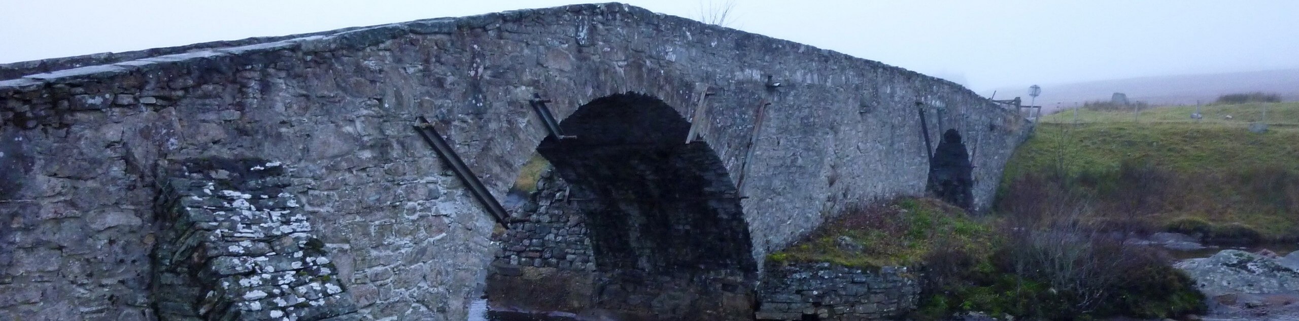
While out on this walk, you’ll likely find yourself in the company of another hillwalker or two, but besides that, you’ll enjoy this peaceful slice of wilderness mostly to yourself. Red deer are known to frequent the area and early on, you’ll also cross a historical stone bridge constructed by General Wade.
From the parking area, begin the walk by crossing the Garva Bridge and taking the next right to join a track that leads away from the road heading north. When a second track is reached, turn right on it and head across another bridge, this one arching above the Allt Coire Iain Oig. On the far side continue on the track heading left and then make your way across the worse fence to your left. Continue upstream, enjoying the solitude of the grassy banks that lead alongside the river.
Up ahead, after following the river for some time, make your way through a break in the fence. Boggy moorlands make up much of the next section as you set out towards the Allt Coire nan Dearcag, which you’ll continue alongside for some time.
When a suitable place for crossing is spotted, head across the burn and join the path that leads up the wide ridge of Geal Chàrn. Views of Creag Meagaidh soon come into view, as well as expansive views across the sprawling glen.
Ascend northeast, pressing on to reach the flat plateau. From the plateau, you’ll reach the summit in around 2297ft, which is marked by a sizable cairn. Upon reaching the cairn, views of the vast wilderness extending north will take your breath away. A feeling of smallness will likely be achieved from atop the summit, with nothing but wide-open land as far as the eye can see.
When you’re ready to set off on your descent, retrace your steps to return the same way back to the parking area where the walk began.
Similar hikes to the Geal Chàrn Walk hike

Glen Banvie Trail and Blair Castle Walk
The Glen Banvie Trail and Blair Castle Walk is a great adventure in Cairngorms National Park that takes in the…

Beinn Udlamain Munro and Sgairneach Mhòr Walk
The Beinn Udlamain Munro and Sgairneach Mhòr Walk is a rugged and exciting journey in Cairngorms National Park that will…

Loch an Eilein, Loch Gamhna, Old Logging Way Loop
The Loch an Eilein, Loch Gamhna, Old Logging Way Loop is a wonderful walking trail in Cairngorms National Park that…
Comments