Dalwhinnie to Culra Walk
View Photos
Dalwhinnie to Culra Walk
Difficulty Rating:
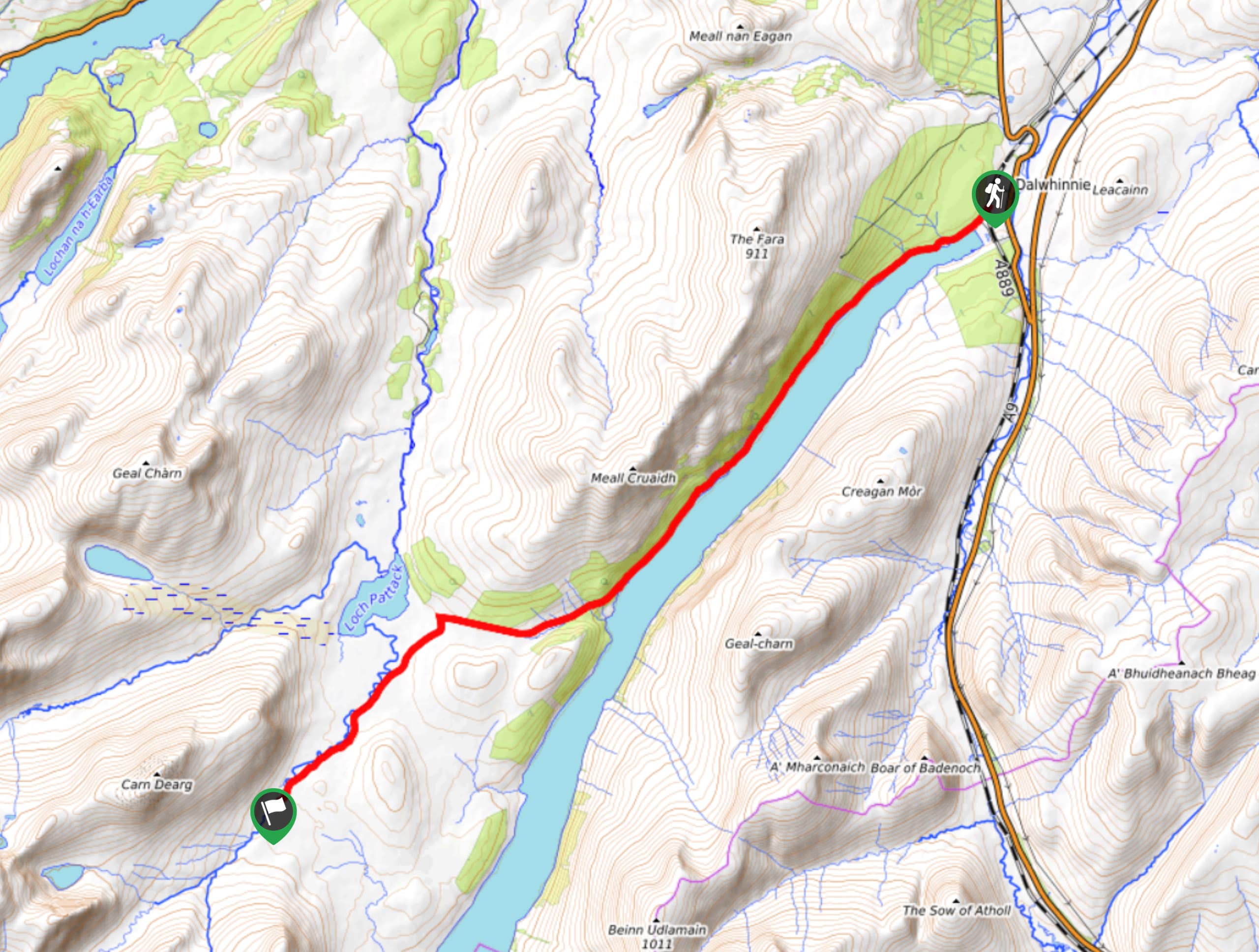
The 9.3mi Dalwhinnie to Culra Walk traverses a wild and remote landscape to enter the very heart of the Central Highlands. The purpose of this walk is generally to reach the start point of the Ben Alder and Beinn Bheòil Walk, which is only accessible by bike or on foot. If you’re interested in exploring a truly remote area of the Cairngorms National Park, however, this route can also be enjoyed on its own.
Getting there
To get to the Dalwhinnie to Culra Walk from the nearby Dalwhinnie Distillery, head northeast, then turn right toward General Wade’s Military Rd/A889. Turn right onto General Wade’s Military Rd/A889, then continue 0.4mi before turning right again. Continue 0.2mi, then turn left onto Ben Alder Rd and continue another 0.2mi to reach the level crossing in Dalwhinnie, where the walk begins

About
| When to do | Year-Round |
| Backcountry Campsites | Wild Camping |
| Pets allowed | Yes |
| Family friendly | No |
| Route Signage | Average |
| Crowd Levels | Low |
| Route Type | Out and back |
Dalwhinnie to Culra Walk
Elevation Graph
Weather
Dalwhinnie to Culra Trail Description
The Dalwhinnie to Culra Walk is a walk with a purpose! That purpose is generally to get to the starting point of the much more challenging Ben Alder and Beinn Bheòil Walk, which is not accessible by car. To begin the walk, park before the level crossing, which you can find by turning left when heading towards the Dalwhinnie Station, then following the road to the crossing. Parking is prohibited at the railway station itself when doing this walk, so avoid that car park at all cost. To begin the hike, set out from the crossing and join the road on the far side. You’ll soon reach the shoreline of Loch Ericht and continue lochside past a gatehouse. Take in the splendour of the revamped Ben Alder Lodge, which you’ll spot near the end of the track. Pass by An Tochailt (another estate house) and continue the track as it enters a forested area. When you reach a defining fork in the track, take the upper right-hand way and begin to climb as the road unfolds in an undulating fashion. Keep right as the driveway to the estate forks to the left and begin to climb behind the house. Pass through a gate and cross a bridge to enter open grounds.
You’ll soon be greeted by the welcome sight of the mountains rising in the distance as the route gradually becomes more and more remote. You’ll pass by some forestry and before you reach the second section of forestry, look for the path on the left, right as the track begins to descend towards Loch Pattack. Look out for the hayrack that marks this point! Stick to the stony path as the Culra Bothy (looking much like a toy house from this distance) soon appears in the far distance. Continue just over 2.0mi on the path before turning right at a sign for a bridge. Head across the bridge and then make a left on the track to reach Culra Bothy.
If you plan to spend the night before tackling Ben Alder and Beinn Bheòil, find a nice spot on the grassy fields around the shelter and enjoy this little slice of heaven!
Other Great Walks in Cairngorms National Park
Check out our trail guides to Ben Magdui, Loch Muick, Ben Vrackie, Loch an Eilein, and the Mount Keen Walk. Or see all of our Cairngorms walks.
Similar hikes to the Dalwhinnie to Culra Walk hike

Glen Banvie Trail and Blair Castle Walk
The Glen Banvie Trail and Blair Castle Walk is a great adventure in Cairngorms National Park that takes in the…

Beinn Udlamain Munro and Sgairneach Mhòr Walk
The Beinn Udlamain Munro and Sgairneach Mhòr Walk is a rugged and exciting journey in Cairngorms National Park that will…

Loch an Eilein, Loch Gamhna, Old Logging Way Loop
The Loch an Eilein, Loch Gamhna, Old Logging Way Loop is a wonderful walking trail in Cairngorms National Park that…
Comments