Creagan Riabhach Walk
View Photos
Creagan Riabhach Walk
Difficulty Rating:
The Creagan Riabhach walk is a spectacular day-walk from Ballater that will take you up into the hills for views of Cairngorms National Park. While out walking the trail, you will skirt around the slopes of Craigendarroch and climb up to the summit of Creagan Riabhach, where you will enjoy splendid views across Deeside. This is a fantastic walking adventure in the Cairngorms if you are looking to get the lay of the land.
Getting there
The trailhead for the Creagan Riabhach Walk can be found at the Ballater Royal Station.

About
| Backcountry Campground | No |
| When to do | March-October |
| Pets allowed | Yes - On Leash |
| Family friendly | Older Children only |
| Route Signage | Average |
| Crowd Levels | Moderate |
| Route Type | Circuit |
Creagan Riabhach Walk
Elevation Graph
Weather
Creagan Riabhach Walk Description
Featuring a wonderfully scenic hilltop summit with views that stretch out across Cairngorms National Park to Morven in the north and Lochnagar in the southwest, the Creagan Riabhach Walk is an excellent adventure if you are looking for some pretty views of the undulating landscape of the park.
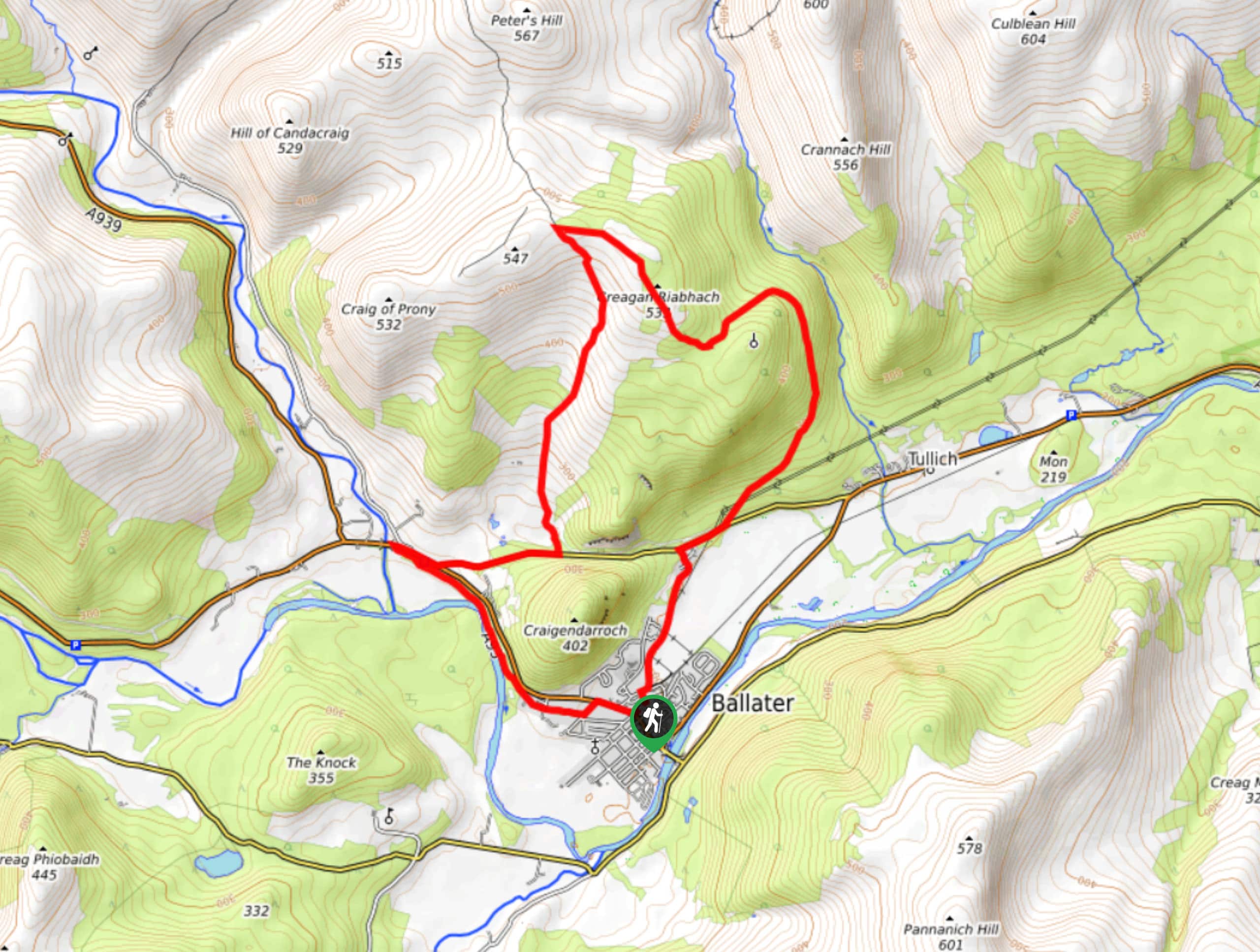
Setting out from the trailhead in Ballater, you will head to the northeast along Cinder Track and follow it until you meet up with B972. Here, you will turn right and follow the road for a short distance, before breaking off to the left to climb high above Deeside.
Reaching the summit of Creagan Riabhach, you will enjoy sweeping views across the valley and surrounding mountains, before turning south on a steep descent of the mountainside. After once again reaching the edge of B972, turn right and follow the road west, where you will soon arrive at the banks of the River Dee. Here, you will pick up a footpath that runs parallel to the riverbank and follow it southeast, enjoying the pleasant riverside setting until you arrive back in ballater where you began.
Similar hikes to the Creagan Riabhach Walk hike

Glen Banvie Trail and Blair Castle Walk
The Glen Banvie Trail and Blair Castle Walk is a great adventure in Cairngorms National Park that takes in the…

Beinn Udlamain Munro and Sgairneach Mhòr Walk
The Beinn Udlamain Munro and Sgairneach Mhòr Walk is a rugged and exciting journey in Cairngorms National Park that will…

Loch an Eilein, Loch Gamhna, Old Logging Way Loop
The Loch an Eilein, Loch Gamhna, Old Logging Way Loop is a wonderful walking trail in Cairngorms National Park that…
Comments