Boar of Badenoch, A’ Mharconaich, and Geal-Charn Walk
View PhotosBoar of Badenoch, A’ Mharconaich, and Geal-Charn Walk
Difficulty Rating:
The Boar of Badenoch, A’ Mharconaich, and Geal-Charn Walk is a rough and rugged adventure in Cairngorms National Park that will take you into the mountains for views of the surrounding area. While out walking this trail, you will traverse the boggy and rugged terrain of its three namesake peaks, where you will have a commanding view overlooking Loch Ericht and nearby mountains. While sections of this route can be a bit poorly marked, it is still a fantastic adventure worth undertaking.
Getting there
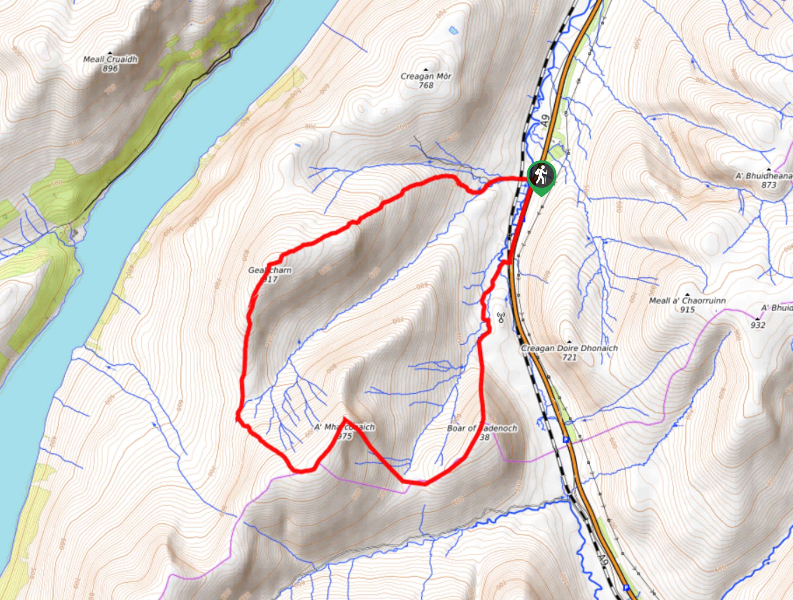
The trailhead for the Boar of Badenoch, A’ Mharconaich, and Geal-Charn Walk can be found at the car park along the A9 near Balsporran Bed and Breakfast.

About
| Backcountry Campground | No |
| When to do | March-October |
| Pets allowed | Yes - On Leash |
| Family friendly | Older Children only |
| Route Signage | Poor |
| Crowd Levels | Moderate |
| Route Type | Circuit |
Boar of Badenoch, A’ Mharconaich, and Geal-Charn Walk
Elevation Graph
Weather
Boar of Badenoch, A’ Mharconaich, and Geal-Charn Walk Description
If you fancy a bit of a challenging route in terms of terrain and navigation, then the Boar of Badenoch, A’ Mharconaich, and Geal-Charn Walk will be a great adventure for you to test your mettle. While the walk isn’t overly difficult, several of the ascents traverse rugged and boggy terrain, and pathways can be poorly marked, making for a fun day of exploration in the mountains. Be sure to bring a GPS in the event that you lose your way.
Setting out from the car park, you will head south alongside A9 for a short distance and branch off to the southwest in order to cross a railway line and the River Truim. Here, you will traverse the valley floor, before making the steep ascent up Boar of Badenoch, where you will have a spectacular sightline across the glen.
Continuing on along the trail, you will traverse the undulating terrain to the west in order to climb to the summit of A’ Mharconaich, before continuing on to Geal-Charn to the north. These last two peaks also offer amazing views of the surrounding landscape, including Loch Ericht to the west. After taking in the views, you will head to the northeast and descend the mountainside on your way into the car park where you began your adventure.
Similar hikes to the Boar of Badenoch, A’ Mharconaich, and Geal-Charn Walk hike

Glen Banvie Trail and Blair Castle Walk
The Glen Banvie Trail and Blair Castle Walk is a great adventure in Cairngorms National Park that takes in the…

Beinn Udlamain Munro and Sgairneach Mhòr Walk
The Beinn Udlamain Munro and Sgairneach Mhòr Walk is a rugged and exciting journey in Cairngorms National Park that will…

Loch an Eilein, Loch Gamhna, Old Logging Way Loop
The Loch an Eilein, Loch Gamhna, Old Logging Way Loop is a wonderful walking trail in Cairngorms National Park that…
Comments