Mount Rundle Scramble
View PhotosMount Rundle Scramble
Difficulty Rating:
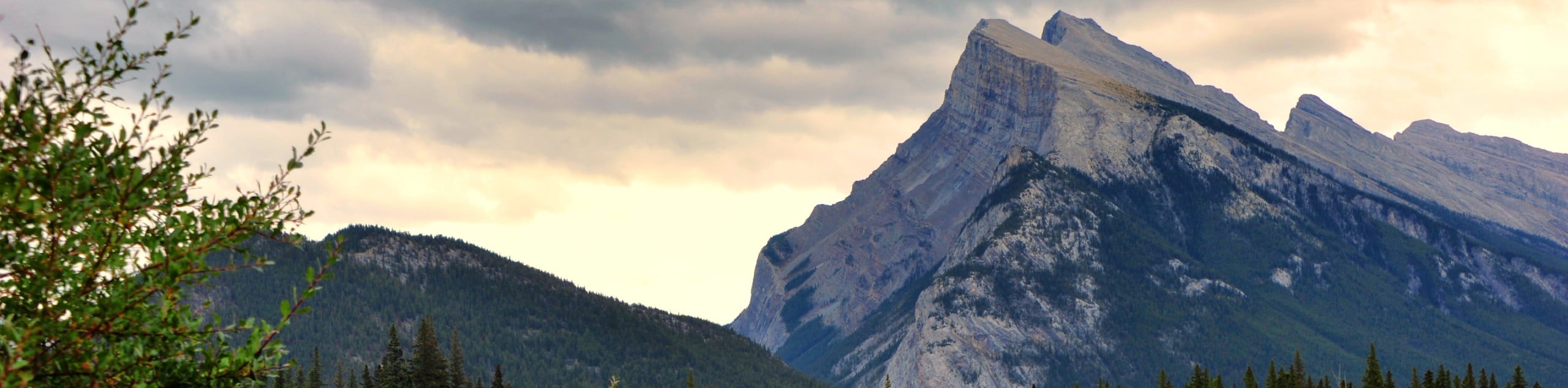
Locals stare at Mount Rundle day in and day out, enough to acquire a personal relationship with the impressive feature. Its stark angle, and swirling weather are enough to push hikers to the top. It is one of those peaks that calls hikers to its summit. It begins with switchbacks through the forest and becomes more technical as it rises with dangerous slab and frustrating scree all the way to the top. The summit rises high above the town of Banff, giving expansive views of the ranges surrounding it.
Getting there
From the Town of Banff, head south on Banff Avenue, crossing over the Bow River Bridge. Turn left onto Glen Avenue and go through the first set of lights. At the second set of traffic lights, turn left onto River Ave, following signs to Bow Falls. Park in the Bow Falls parking lot near the small bridge and gate to the Banff Springs Golf Course. Walk over the bridge and down the golf course road until you reach a trail sign for Goat Creek, Mount Rundle, and Sp6 backcountry campground. This is where your trail begins.

About
| When to do | June-August |
| Backcountry Campsites | No |
| Pets allowed | Yes - On Leash |
| Family friendly | No |
| Route Signage | Poor |
| Crowd Levels | Low |
| Route Type | Out and back |
Mount Rundle
Elevation Graph
Weather
Mount Rundle Trail Description
Scrambling the remarkable Mount Rundle requires experience and endurance. This trail rises 5702ft in elevation from the trailhead to the summit, and it is not easy walking either. Scramblers will encounter slab, scree, and defeating steeps on the way up this monstrous peak. Be ready for a big day if you are choosing to tackle Mount Rundle.
The Cree name for this peak is Waskahigan Watchi, meaning house mountain. In 1858, the mountain was renamed Mount Rundle after Reverend Robert Rundle, who did missionary work here in the Bow Valley. Rundle is one of the most recognizable peaks in the valley and is actually considered a range of its own. The gruelling scramble will give hikers a new perspective on the vast expanse of this small range.
Parks Canada has created a scrambler’s guide to the mountain that is broken up into six sections. If you are looking for a map and route description to pair with your GPS, head to the visitor centre for a copy or download one from their website.
Starting at the Spray trailhead on the golf course road, head into the forest along the Spray River. You will be travelling on the right side of the mountain’s slopes. Soon you will come to a trail sign that will direct you onto the official Mount Rundle trail to the left. Follow this through the forest until you reach some steep switchbacks.
Make your way through the forested switchbacks, enjoying the shade while you can. Mount Rundle is extremely exposed once you leave the treeline, and there are no water sources high up on this trail. The switchbacks will lead you to a band of cliffs that can be hazardous, so be sure to know your route and stay on the trail. The trail traverses to the right and crosses some ravines. After the second ravine, the trail meets a rock gully called the central gully.
The central gully is where the hiking trail ends, and the scrambling route begins. Scramblers may feel encouraged to climb straight up the gully; however, this is not the route! Follow the scramble route across the gully to the right of a rocky outcrop and avoid the gully as it steepens drastically and forms into dangerous slabs. Yellow markers define the descent route to avoid difficult cliff bands and other dangerous features. Look back to spot the yellow markers and remember them for your descent.
After crossing the gully and making it to the rocky outcrop, you will scramble up the route through trees to the right of the rocky outcrop. This route can be slippery, so be careful. 328ft up the slope, the path traverses to the right. After this short horizontal traverse, head straight up through the forest. A well-worn path will lead you towards the treeline, but it is very steep and slippery.
Once you meet treeline, you will come to the infamous Dragon’s Back. This ridge is situated between the central gully and another large gully to the right. It is a spine-like feature appropriately named the Dragon’s Back. It is made of smooth limestone with loose gravel on top and steep cliffs on either side. This is extremely dangerous and slippery, so proceed with caution and remember to look back for landmarks.
After your slog up the Dragon’s Back comes to an end, you will encounter deep and difficult scree along the summit ridge. The ridge is a sharp edge with a vertical drop to the east face of the mountain. Follow the ridge to the summit cairn, where a moderate flat spot makes for a well-deserved rest. Enjoy the views and try your turn at naming surrounding peaks and ranges. Descend the way you came and watch for trail markers!
Trail Highlights
The Dragon’s Back
The famous Dragon’s Back can be seen from town or especially from across the valley on the Sulphur Mountain trail. It is a distinct feature that has formed a spine between two gullies. This is known to be the most difficult and dangerous section of the scramble route. Watch out for loose gravel on this section, the Dragon’s Back will pull your feet right out from under you!
Insider Hints
Be prepared for a long day on the mountain.
Pack plenty of food and water for this arduous hike.
Avoid cornices if there is snow coverage! These can be deceiving.
Treat yourself to some food and drinks at the Waldhaus Bavarian Pub nearby.
Head to the Banff Upper Hot Springs for a relaxing soak, where you can catch views of Mount Rundle from the pool.
Similar Scrambles to the Mount Rundle Scramble
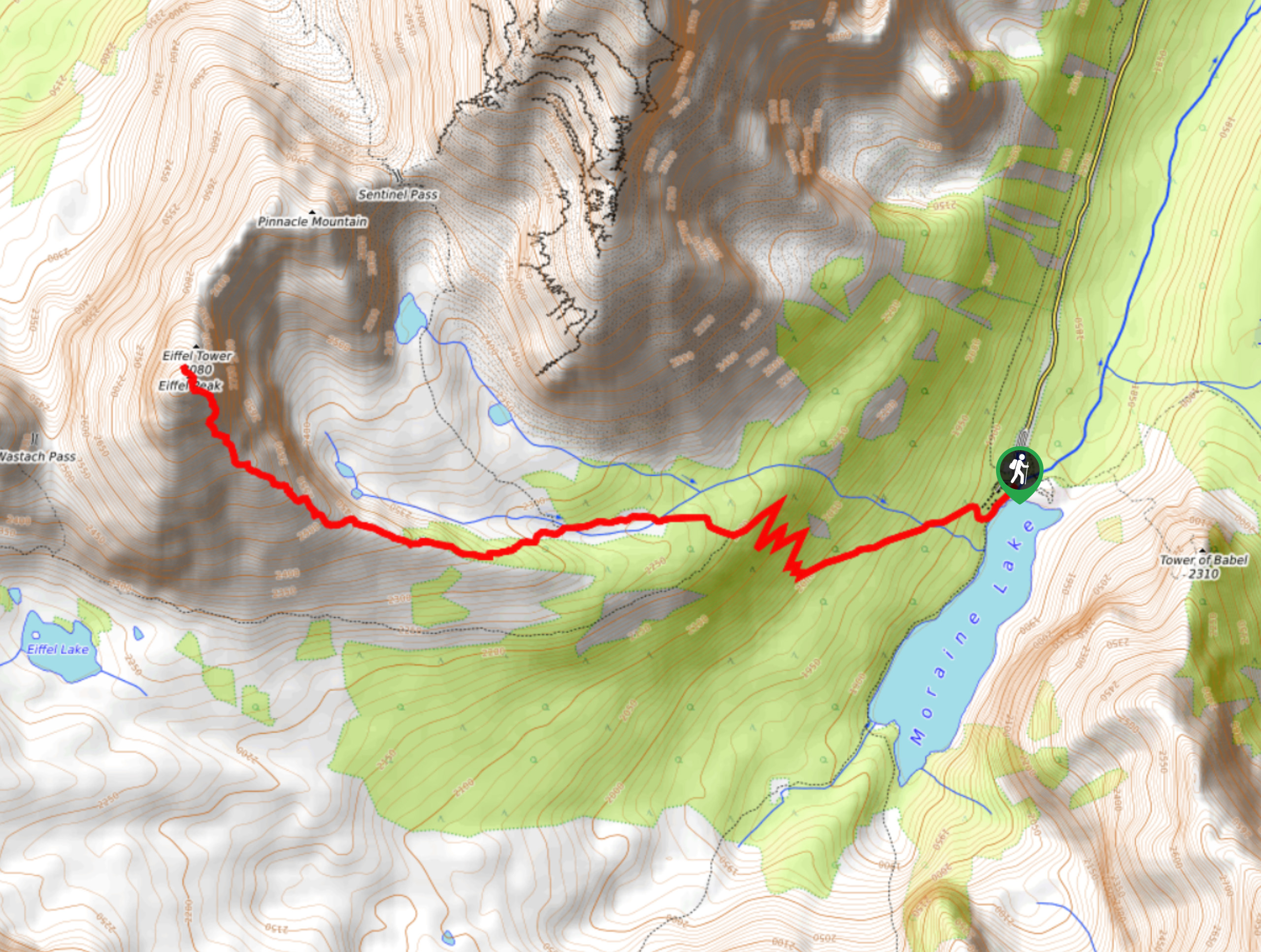
Eiffel Peak
Eiffel Peak isn’t frequented by many who make their way to Moraine Lake. It is a difficult scramble with less…
Mount Edith
Mount Edith scramble begins with the unsuspecting Cory Pass hike before branching off to the right to begin gaining Mount…
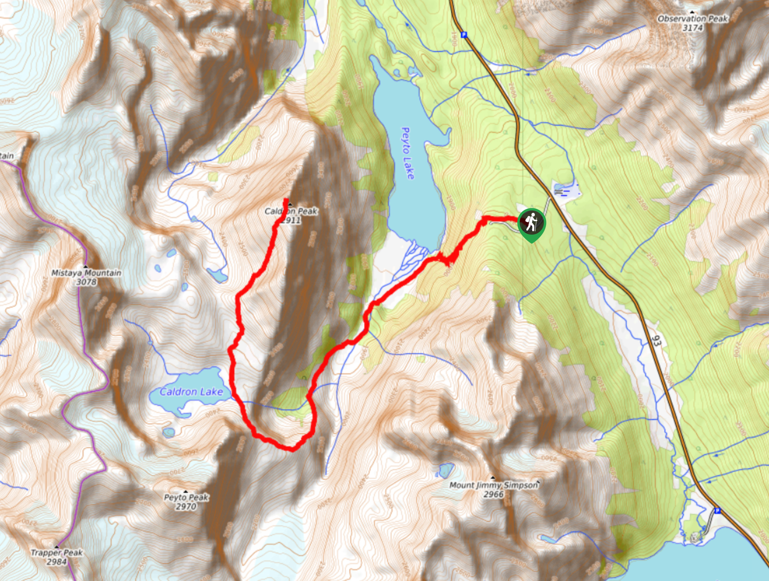
Caldron Peak
Caldron Peak is a scramble that requires a lot of effort. There are creek crossings, glaciers, multiple alpine lakes, and…
Comments