The Subway Trail
View Photos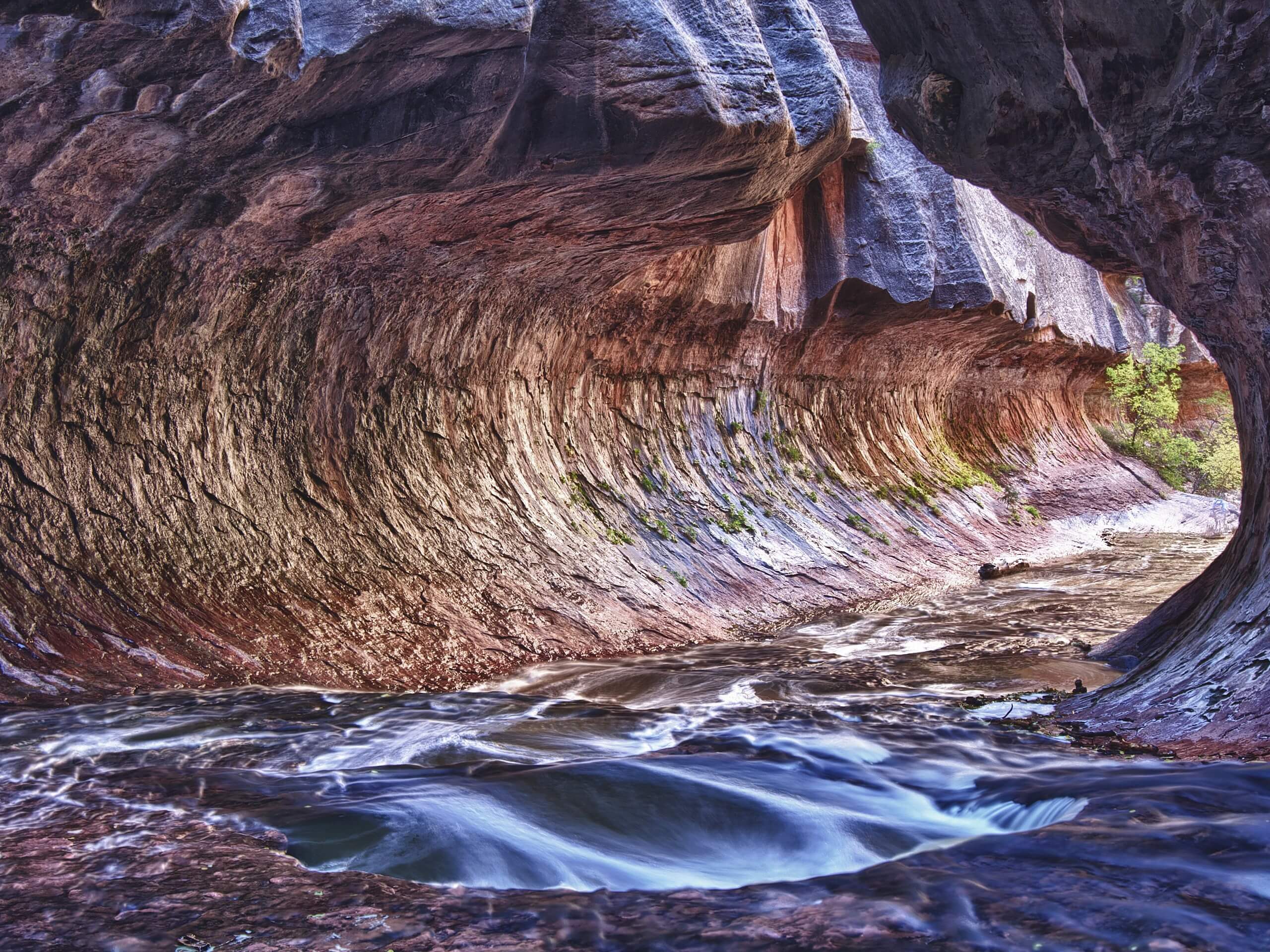
The Subway Trail
Difficulty Rating:
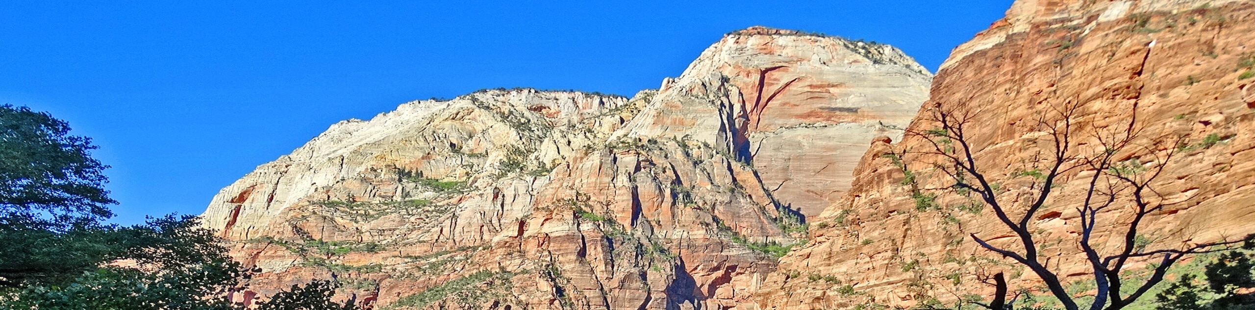
The Subway Trail is an iconic hike in Zion National Park that features paleontological wonders, breathtaking waterfalls and the picturesque Subway rock formation. This hike is a full-day, semi-technical trek and is recommended for experienced hikers only. A backcountry permit is required to access this route.
Getting there
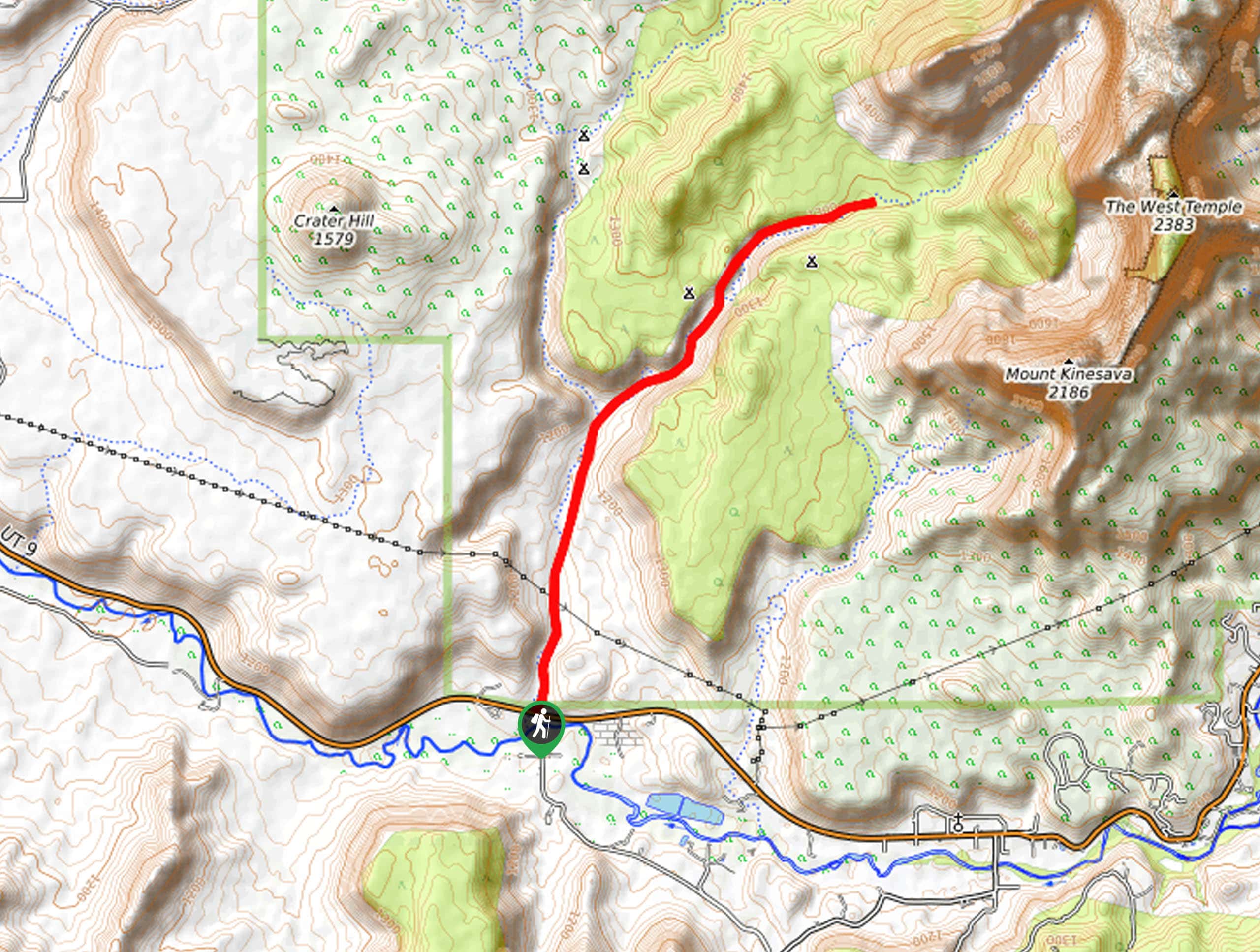
The Subway Trail starts at the Left Fork of North Creek Trailhead just off of Kolob Terrace Road.

About
| Backcountry Campground | No |
| When to do | June to October |
| Pets allowed | No |
| Family friendly | No |
| Route Signage | Poor |
| Crowd Levels | Moderate |
| Route Type | Out and back |
The Subway Trail
Elevation Graph
Weather
The Subway Trail Description
The Subway Trail is a challenging trek of otherworldly beauty. A worthy opponent for even the most experienced hikers, The Subway Trail demands that hikers navigate their way through pools of cold water, scramble up steep, slippery rock, and be vigilant about their surroundings as the area is prone to flash flooding. Do not do this hike if there is rain on the horizon. This hike enters the Zion Wilderness Area, so you will need to acquire a permit from the National Park Service before beginning. Upon purchase, Park Rangers will give you a safety briefing before sending you on your way.
All the challenges that are posed by the Subway Trail are equally matched in the sheer beauty of this hike. The terrain will change as you hike downwards from the hot, sandy landscape near the parking lot to the cool, rocky world of the canyon. As you continue on, the myriad of waterfalls, high arching rock walls, and the amazingly preserved dinosaur tracks will make this a hike to remember.
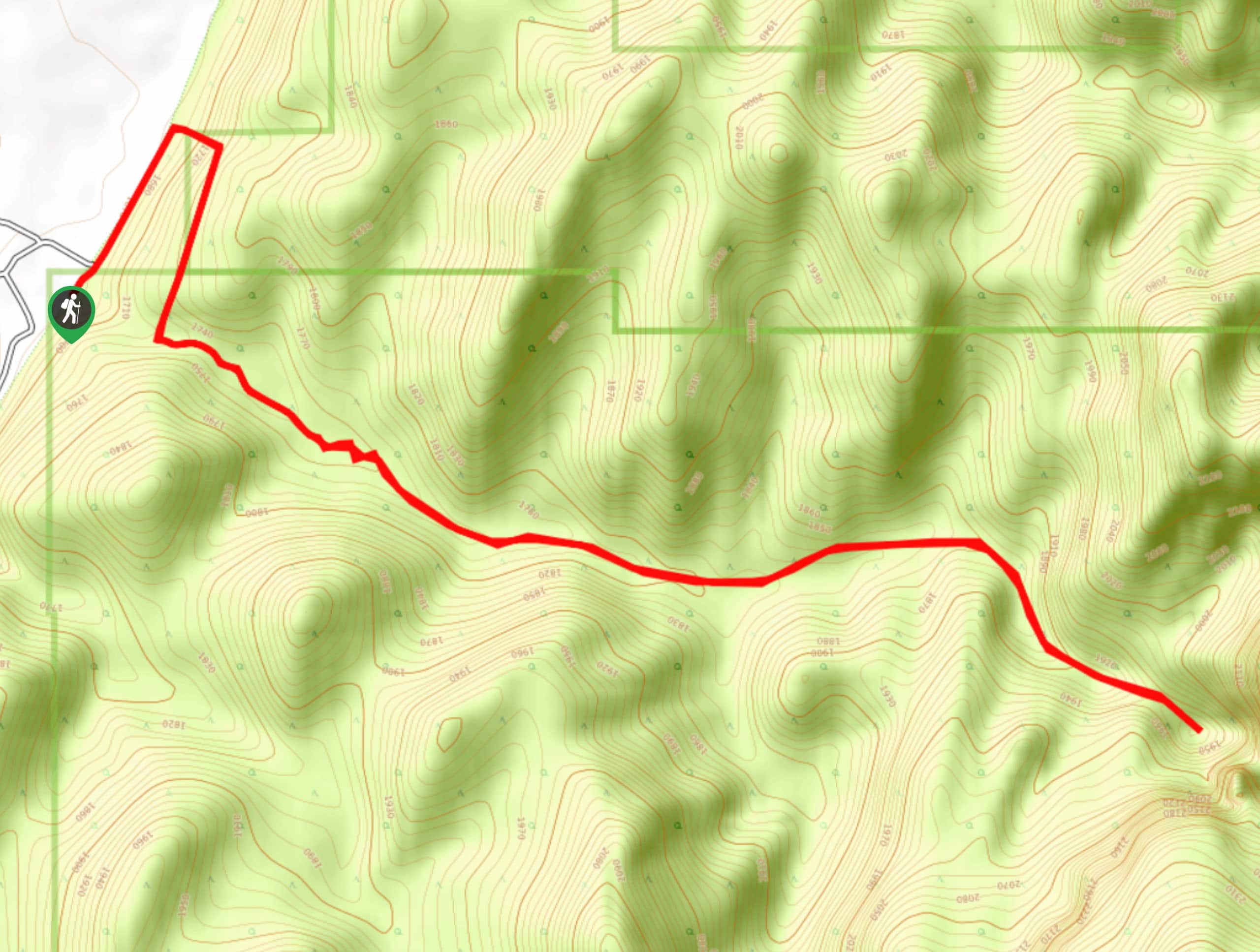
Starting at the left fork of North Creek Trailhead, follow the well-travelled trail northeast for about half a mile. Stop and admire your view of the cliffs overlooking the Left Fork before descending a steep series of switchbacks into the canyon. At the bottom, take a look back or drop a pin on your GPS: you will have to climb back up this trail at the end of your hike. In their tired stoop, many hikers have walked past this divergence and ended up with more of an adventure than they signed up for. Once you’ve taken a mental picture of your exit route, continue up the canyon. The trail here becomes increasingly vague, but as long as you follow the water, you will be okay. At this point, the trail becomes your own adventure: hop right into the creek and wade your way upwards, or clamber over boulders along the river’s edge. Keep in mind that you will likely have to get your feet wet at some point, so you may as well embrace it and have fun!
After about a mile of hiking along the creek, keep your eyes peeled for the beautifully preserved dinosaur tracks along the north side of the creek. Hikers have constructed an arrow out of stones to make these obvious for each other as it is a must-see along the route. After snapping some photos and comparing your feet with those of an ancient theropod, continue along the stream for another two miles where you will come across a beautiful staircase cascade. The rocks here are very slippery, so take your time and watch your step. A few miles later, the canyon will take a hard right, and you will come upon this hike’s namesake: The Subway. Here, the canyon walls arch overhead and almost touch. Weeping walls, and emerald potholes abound; this is truly a special place. If conditions are right, and you’re willing to go for a swim, continue on past The Subway to The Waterfall Room, where a log jam has created a 20ft tall waterfall that pours into the canyon.
Bask in the awe of the lower Subway, but not for too long, as the most strenuous part of the hike is still ahead of you. Retrace your steps down the cascades, and past the dinosaur footprints back to the parking lot. Keep your eyes out that mental picture of your ascent trail you took earlier, or otherwise stay attuned to your GPS—you do not want to miss your turn-off, and it’s important to be out of the canyon before dark. Be warned that the hike back up the final stretch of trail is steep, loose and often knocks the wind out of hikers after a long day of enjoying the canyon. You may be sore and tired at the end of the day, but you’d be crazy to say it wasn’t worth it. The Subway Canyon hike is a must-do, and will be a highlight of your time in Zion National Park.
Trail Highlights
Dinosaur Tracks
Located on the North side of the creek, about a mile in, there are a set of beautifully preserved dinosaur tracks. These footprints are likely from a Theropod (three-toed dinosaur) called Dilophosaurus. Dilophosaurus was an approximately 20ft long, 700lb carnivorous creature that lived during the Early Jurassic Period about 193 million years ago.
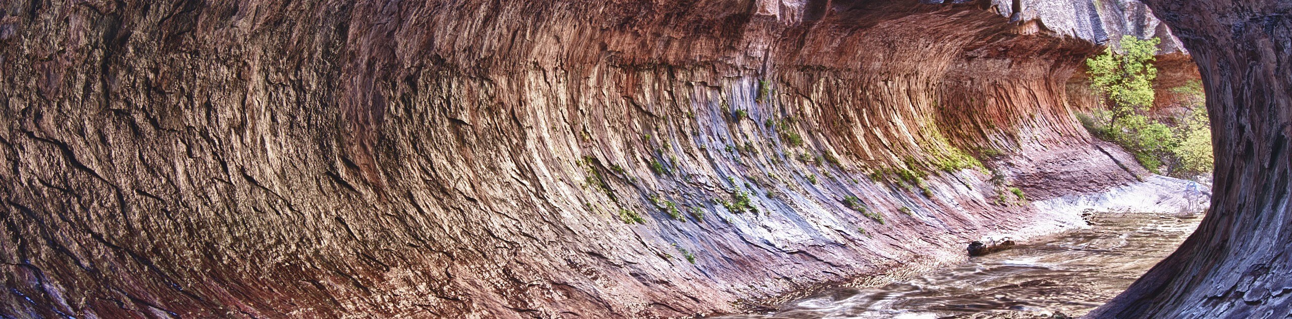
The Subway
The Subway is a quarter-mile-long passage through a section of canyon where the two walls almost kiss to create a subway-tunnel-like framework of desert stone. The shady chamber houses emerald green potholes and glimmer and glisten in a trickle of sunlight that shines through the canyon slot. Truly a sight to be seen, this formation is worth the wet feet and achy muscles.
Frequently Asked Questions
Can anyone hike The Subway in Zion?
The Subway Trail is recommended for experienced hikers only.
What do I need to hike The Subway Trail in Zion?
A backcountry permit is needed to access this trail. Permits are issued by the National Park Service on a first-come-first-serve basis. Permit reservations can be made in advance online or can be purchased “last minute” if unreserved spots are available. Permits must be picked up from the Zion Canyon Visitor Center Wilderness Desk either the day before, or the day of your hike.
Insider Hints
The Subway trail features beautiful, otherworldly terrain, do not forget a camera.
This is a full-day expedition: start early, and give yourself enough time to make it back to your car before dark. We recommend picking up your permit the day before your hike so you don’t waste daylight waiting in line at the permit office.
The Subway Trail can also be done “top-down” as a canyoneering route.
Wet feet are inevitable but wet and cold feet can be avoided: wear socks made of neoprene or thick wool. These materials will keep you warm even when wet, avoid cotton socks at all costs.
The trail back to the car out of the canyon is the hardest part of this hike, save your energy and some snacks for the final push.
Similar hikes to the The Subway Trail hike
Scoggin’s Wash
The Scoggin’s Wash Trail is a true desert hike that links the more popular Coalpits Wash Trail with the iconic…
Camp Creek Trail
The Camp Creek Trail is a rarely visited path down a beautiful box canyon in the Kolob section of Zion.…
Elephant Temple via The Riverside Walk
The hike through the Narrows to the base of Elephant Temple is a challenging day hike through one of the…
Comments