

Gibson Lake Loop Hike
View PhotosGibson Lake Loop Hike
Difficulty Rating:
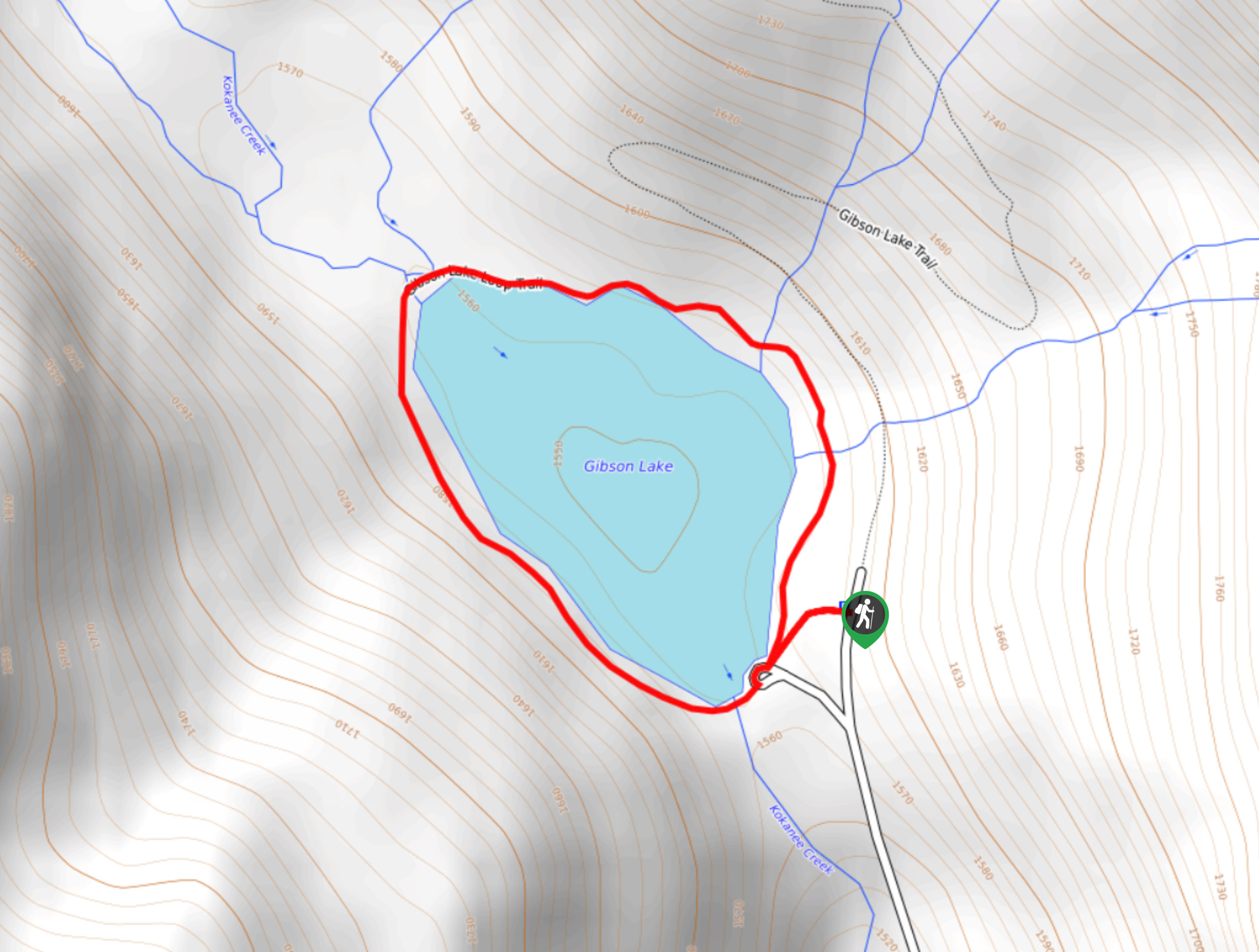
The Gibson Lake Loop Hike is a short 1.2mi hiking route in Kokanee Glacier Provincial Park that travels around the peaceful shores of Gibson Lake and offers a scenic backdrop of rugged mountains. As the main access point for the park, this trail can become fairly busy, especially in the summer months, so make sure to arrive early to secure parking and enjoy the trail. The short distance and level terrain make this a great family-friendly route where you can explore the beauty of the park.
Getting there
To get to the Gibson Lake trailhead from Nelson, head north on BC-3A for 12.2mi and turn left on Kokanee Glacier Road. In 9.7mi, you will arrive at the parking area on the left.
About
| When to do | Year-Round |
| Backcountry Campsites | No |
| Pets allowed | No |
| Family friendly | Yes |
| Route Signage | Average |
| Crowd Levels | Moderate |
| Route Type | Lollipop |
Gibson Lake Loop Hike
Elevation Graph
Weather
Gibson Lake Loop Hike Description
The Gibson Lake Loop Hike is a nice-and-easy circuit that is suitable for outdoor enthusiasts of all skill levels and provides some beautiful scenery of the surrounding area. Due to the location of the route near the entrance of the Kokanee Glacier Provincial Park, hikers will want to arrive early to a spot in the limited parking area and have this picturesque trail all to themselves for a bit.
This hiking route is an easy loop around the calm waters of Gibson Lake and provides an amazing view over the surrounding woodland landscape, making it the perfect spot for a fun day on the trails with family and friends. Looking out across the water, hikers will have a sightline that includes densely wooded evergreen forests and rugged mountain peaks, such as The Pyramids to the north, Kokanee and Grays peaks to the east, and Outlook Mountain to the west. If you find yourself heading towards Kokanee Glacier Provincial Park, then there is no reason not to stop near the entrance to experience this fantastic hike.
Setting out from the parking area on the southeast corner of the lake, follow the trail as it heads north along the tranquil wooded shoreline. After roughly 820ft, you will cross over two small creeks and continue along the northern edge of the water. Here, you will make your way over Kootenay Creek and have a nice view through the valley to the north towards Mount John Carter.
As you make your way around Gibson Lake, take some time to experience the tranquil woodland atmosphere and relish in the natural beauty of the surrounding landscape. Working your way around the western edge of the lake, you will have views that stretch across the calm water towards Kokanee Peak and Grays Peak to the east.
After finishing the short loop, you will arrive back at the trailhead next to the parking area where you began your hike. From here, you can either spend some time hanging out by the water, or head further into Kokanee Glacier Provincial Park to experience more of its amazing trails.
Insider Hints
Arrive early to secure parking and beat the crowds.
Any type of comfortable footwear is suitable for this quick hike.
Similar hikes to the Gibson Lake Loop Hike hike
Wilson Creek Falls Trail
The Wilson Creek Falls Trail is a 1.8mi out-and-back route in Goat Range Provincial Park that travels along…
McPhee Waterfalls Hike
The McPhee Waterfalls Hike is a 3.5mi out-and-back hiking route near Castlegar, BC, that will take you along…
Merry Creek Trail
The Merry Creek Trail is a 2.8mi lollipop hiking route in Castlegar, BC that passes through a picturesque…


Comments