

Lone Mountain Hike
View PhotosLone Mountain Hike
Difficulty Rating:
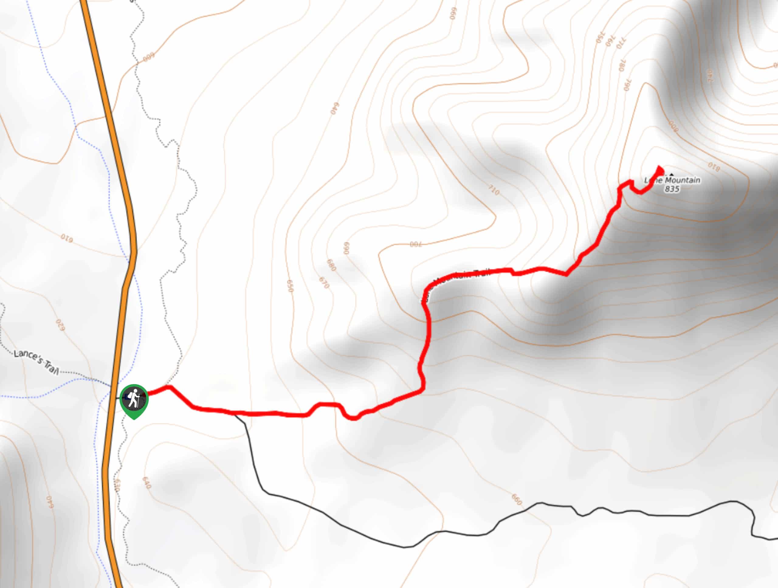
Lone Mountain, also known as EJ Peak by locals, is a 2800ft mountain in the Usery Range just outside of Phoenix. The trail up the mountain and back is only 2.3mi roundtrip, making this one of the easier summits you can bag. From the top, enjoy a fantastic view of Pass Mountain, Brown’s Peaks, McDowell Peak, and the rest of the Goldfield and Usery Mountains in the distance.
While the route is short, it’s fairly steep. Small kids might struggle with this one, but active older children should have no problem. Since this hike is out in the sun for the entirety of the trail, you’ll definitely want sunscreen, a hat, and lots of water. We recommend leaving this trail for the fall, winter, and early spring to avoid the worst of the heat.
Getting there
The trailhead for the Lone Mountain hike is off N Usery Pass Road.
About
| Backcountry Campground | No |
| When to do | October-April |
| Pets allowed | Yes - On Leash |
| Family friendly | Older Children only |
| Route Signage | Poor |
| Crowd Levels | Extreme |
| Route Type | Out and back |
Lone Mountain Hike
Elevation Graph
Weather
Lone Mountain Hike Description
Lone Mountain is a quick win just outside of Phoenix with excellent views from its summit. This mountain is commonly referred to as EJ Peak by locals, but no matter what you call it, it’s the perfect hike to explore when you want lots of reward on a short trail.
While the hike is quick, it is quite steep. Don’t underestimate the effort required, especially in the heat. We don’t recommend this route in the summer and you’ll need to bring lots of water at all times of the year.
Young children might get tired out on this hike, and beginners might find it more strenuous than moderate but should still be able to make it to the top.
You’ll want to park at the Bulldog Canyon Off-Highway Ara parking three miles north of N McDowell road on N Usery Pass Road. The trail starts about 250 yards east of the parking area. There isn’t a trail marker, but you should be able to make out the obvious route.
Head towards EJ Peak and stay left where FS 3554 splits off to the right. After this, there aren’t any major junctions to navigate.
The grade is fairly relaxed at first, then it increases as you draw nearer to the summit. Admire the tall saguaros that flank your trail and keep an eye out for desert critters, who frequent this area at certain times of the year.
The footing is fairly stable, mostly packed dirt with a few bigger rocks to navigate. Poles might be helpful as you near the top, but they’re not entirely necessary.
After a mile and some change, you’ll reach the summit. Look down to Pass Mountain to the south, the tallest immediate neighbor to EJ Peak. You can also see the Usery Mountains to the west and the Goldfield Mountains to the east. The far reach of the Phoenix metro area extends to the southwest.
From the summit, the route down is easy. You’ll retrace your steps back to the trailhead, enjoying the quicker pace of the descent.
Hiking Route Highlights
Usery Mountains
You’ll have a clear view of the Usery Mountains atop Lone Mountain. The Usery Mountain Regional Park covers 3,648 acres and offers camping, hiking, archery, and more. With 29.0mi of multi-use trails and classic Central Arizona scenery, it’s worth exploring after you’ve scoped it out from above.
Frequently Asked Questions
Is there a fee for Lone Mountain?
There is no pass, permit, or fee required to hike this trail.
Is EJ Peak the same as Lone Mountain?
Yes, the mountain goes by both names. Topographic maps refer to it as Lone Mountain while locals call it EJ Peak.
Insider Hints
There’s also a Lone Mountain in Nevada. If you’re visiting, don’t confuse the two!
This area is subject to closure due to wildfires. If there are fires in the area, plan to return another time.
Similar hikes to the Lone Mountain Hike hike
Jacob’s Crosscut Trail
Jacob’s Crosscut Trail is an important route in the network of trails in Lost Dutchman State Park. This route is…
Bronco Trail
The Bronco Trail is a 7.9mi out and back route used for hiking and horseback riding. This trail…
Pine Canyon Trail Loop
The Pine Canyon Trail Loop in Pine, Arizona is a quick 2.7mi loop that is rated as easy.…


Comments