

Bulldog Saddle and Pass Mountain Trail Loop
View PhotosBulldog Saddle and Pass Mountain Trail Loop
Difficulty Rating:
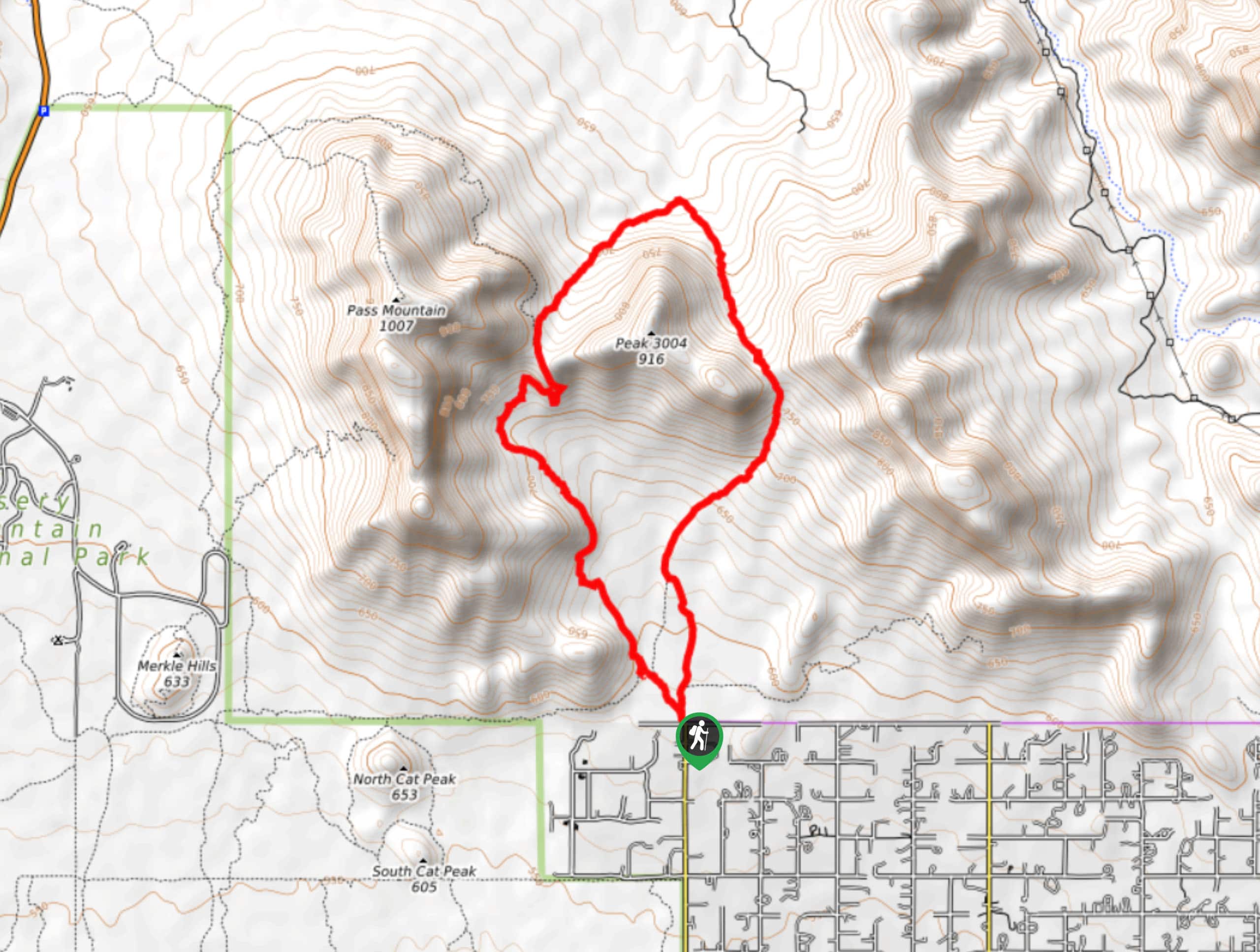
The Bulldog Saddle and Pass Mountain Trail Loop is a fun hike that starts right from the city limits of Apache Junction, Arizona. The hike takes you all the way around Peak 3004 and beside Pass Mountain. The views are awesome and the hike will get your legs working without being overly strenuous. This is a good pick if you want to feel like you’re in the mountains without having to actually climb one.
This hike isn’t very well-signed, so we recommend bringing a downloaded GPS track to help you find your way. Additionally, as with all hikes in Central Arizona, the temperatures on this trail can soar. We suggest trying this hike outside of the extremely hot summer months (June-August) and bringing more water than you think you’ll need at all times of the year. Sunscreen and a hat are also recommended.
Getting there
The trailhead for the Bulldog Saddle and Pass Mountain Trail Loop is near the northern terminus of N Meridian Drive.
About
| Backcountry Campground | No |
| When to do | October-May |
| Pets allowed | Yes - On Leash |
| Family friendly | Yes |
| Route Signage | Poor |
| Crowd Levels | Extreme |
| Route Type | Loop |
Bulldog Saddle and Pass Mountain Trail Loop
Elevation Graph
Weather
Bulldog Saddle and Pass Mountain Trail Loop Description
The Bulldog Saddle and Pass Mountain Trail Loop delivers great mountain scenery without requiring you to climb a mountain and without needing to go very far out of town for those in the Apache Junction area. Departing right from the edge of town, it feels very remote for an easily-accessible hike.
This route isn’t very well-signed despite its convenient location, so we recommend referring to a GPS track if it’s your first time out. Additionally, this trail doesn’t offer much relief in the way of shade and it can get scorchingly hot in this part of Arizona. Bring lots of water, wear sunscreen, and pop a hat on.
This is an especially enjoyable hike when the wildflowers are in bloom, which tends to be around late spring. While mostly used by hikers, trail runners also favor this route and may pass by you as you explore.
Park at the end of N Meridian Drive in the parking area. Head out on the obvious trail, keeping right onto Bulldog Saddle Tail. If you accidentally take the trail on the left, no worries, they rejoin soon enough. If you take the route on the far left, you’ll complete the loop clockwise, which is also fine.
The route is fairly flat to begin with. All warmed up, you’ll begin to climb beside the east side of Peak 3004. The trail loops around the northern corner and turns south to take you between Pass Mountain and Peak 3004.
Note that through this middle section of the hike, the trail becomes quite faint and hard to follow. There’s not much traffic through this route and it’s easy to lose your way. If you do, backtrack to the trail and try again. Some cairns help mark the way.
Look for Lone Mountain all by itself to the northwest. To the northeast and east is a long ridge that flanks the mountains further out.
Climb up the saddle ridge between the two peaks, pausing to appreciate the view on either side of you. You’ll hike through a couple of narrow switchbacks and traverse to your right to hug the base of Pass Mountain on your way down.
Continue following the base of Pass as you approach the trailhead again. Arriving back at the N Meridian Drive Trailhead, it’s off to your next adventure from here.
Hiking Route Highlights
Pass Mountain
Pass Mountain rises above the skyline east of Phoenix and north of Mesa. It’s the highest peak in the Usery Mountains and marks the westernmost point of the Goldfield Mountains, sitting right on the border of both mountain ranges. Some trails head directly up the mountain in addition to hiking and running routes that explore the base of the mountain.
Frequently Asked Questions
Is there parking for the Bulldog Saddle and Pass Mountain Trail Loop?
There is parking available at the end of N Meridian Drive.
Can you climb Pass Mountain?
Yes, you can climb Pass Mountain. This route does not include the summit, but there are routes you can use to access it. Expect a bit of scrambling if you attempt the summit.
Insider Hints
There are lots of other trails you can explore in Usery Mountain Regional Park. The park’s camping can turn this hike into a weekend adventure not far from town.
Similar hikes to the Bulldog Saddle and Pass Mountain Trail Loop hike
Jacob’s Crosscut Trail
Jacob’s Crosscut Trail is an important route in the network of trails in Lost Dutchman State Park. This route is…
Bronco Trail
The Bronco Trail is a 7.9mi out and back route used for hiking and horseback riding. This trail…
Pine Canyon Trail Loop
The Pine Canyon Trail Loop in Pine, Arizona is a quick 2.7mi loop that is rated as easy.…


Comments