
Frying Pan Lakes Trail
View Photos
Frying Pan Lakes Trail
Difficulty Rating:
The Frying Pan Lake Trail is just as exciting and interesting as the name sounds. Though there are no frying pans involved, this epic hike travels through some of the most picturesque scenery up to the basin laden with shimmering lakes and encircled by majestic peaks. This trek is a must-add to your Colorado adventure list.
Getting there
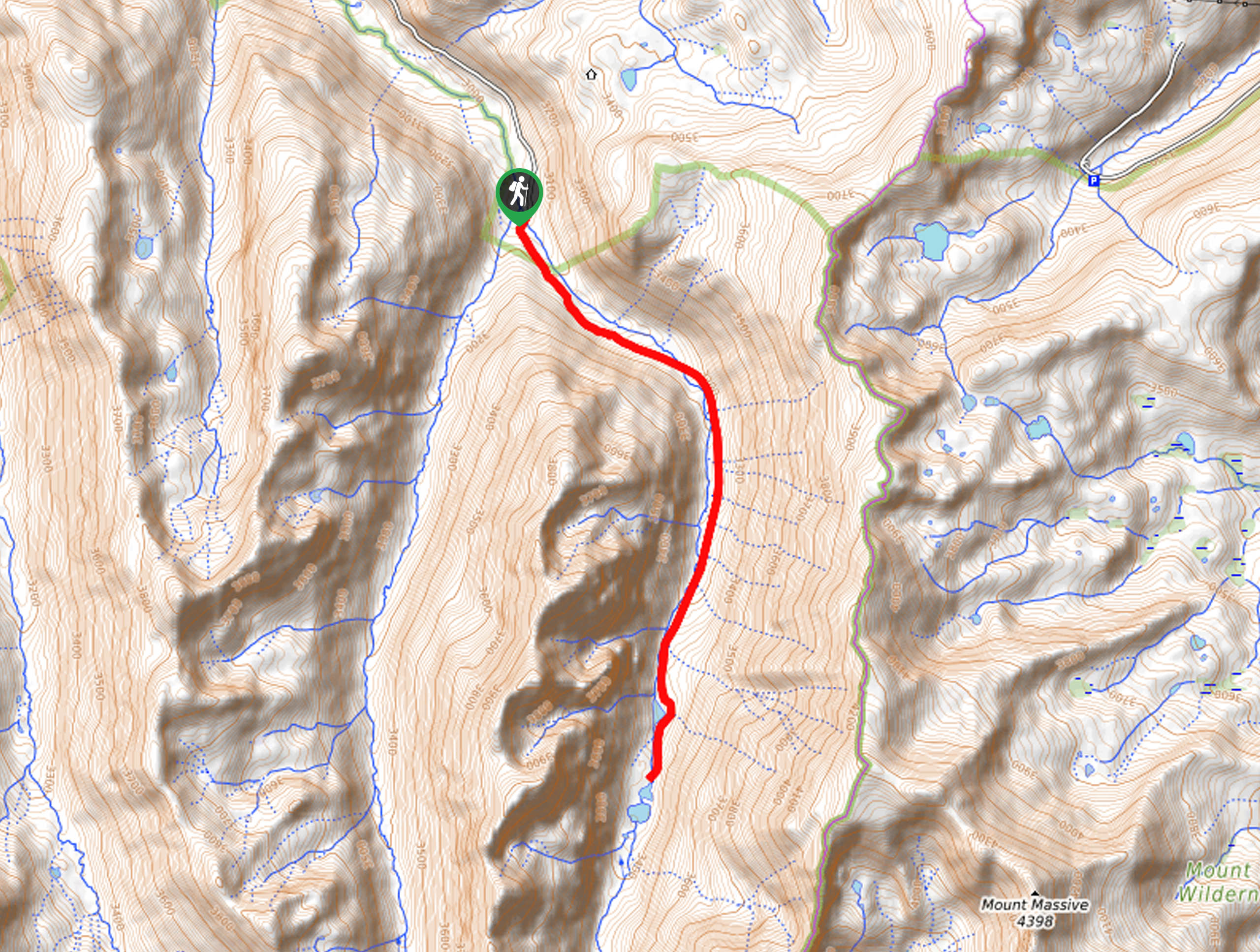
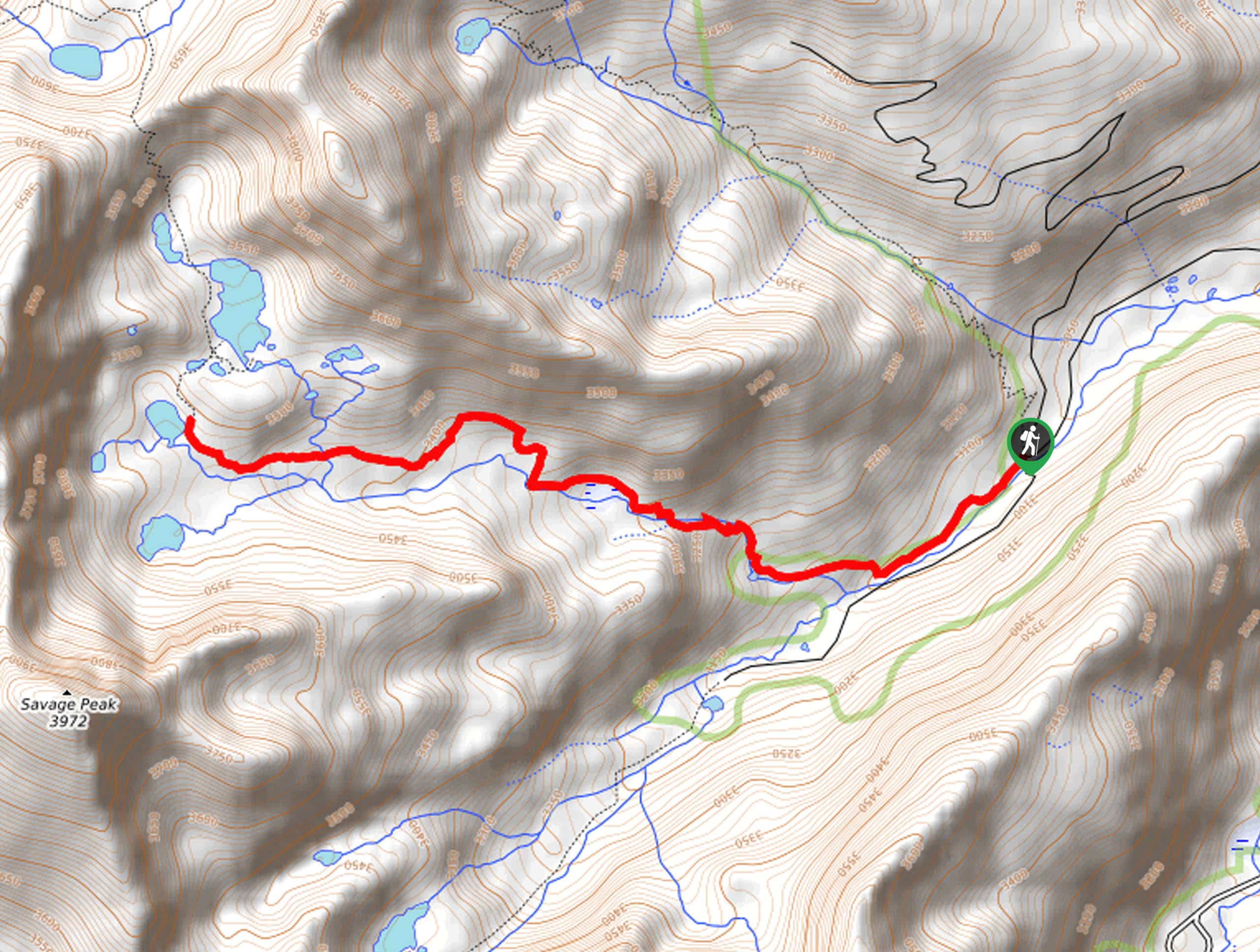
The Frying Pan Lake Trail departs from the Frying Pan Lakes Trailhead off the Nast Tunnel Diversion Road.

About
| Backcountry Campground | Dispersed Backcountry Camping |
| When to do | June-September |
| Pets allowed | Yes - On Leash |
| Family friendly | Older Children only |
| Route Signage | Average |
| Crowd Levels | Moderate |
| Route Type | Out and back |
Frying Pan Lakes Trail
Elevation Graph
Weather
Frying Pan Lakes Trail Description
We love the Frying Pan Lakes Trail, and we think you might too. Exhibiting the diversity of the area’s flora and fauna, this trek will guide you through luxuriant meadows dotted with wildflowers, through dense evergreen woodlands, and along rocky ridges. This deep backcountry adventure also presents the ideal opportunity to wander amongst bears, moose, deer and marmots. If you are nervous about an unwelcomed encounter with wildlife, consider wearing a bear bell! Note this path is subject to blowdowns, so you may have to navigate sections of treefall.
Lace-up your hiking boots and head out on the Frying Pan Lakes Trail from the trailhead at the end of Nast Tunnel Diversion Road. From here, track southeast along the Frying Pan Lakes Trail. The craggy walls will hug you as you travel through the river valley. Enjoy the ambient sounds of the running waters and keep an eye out for wildlife. As you climb, the trail will become increasingly exposed as you near the mountain cirque. Revel in the grandeur of the looming peaks and when you get to the lakes, rejuvenate your feet in the frigid waters.
Notice Mount Massive in the southeast and Deer Mountain and Mount Oklahoma in the south. Appreciate the grandeur of the wilderness, and when you are done reveling in the scenery of the shimmering lakes, backtrack along the path to the trailhead.
Similar hikes to the Frying Pan Lakes Trail hike
Village Creek Trail
Explore the Beaver Creek Ski Resort and revel in the vibrance of the encompassing woodlands as you venture the Village…
Sopris Lake via Brady Lake Trail
Immerse yourself in the jaw-dropping scenery that the Swatch Mountain Range has to offer, as you venture to Sopris Lake…
First Missouri Lake Trail
The First Missouri Lake Trail is a stunning day hike into Colorado’s high country. Explore the alpine terrain and revel…
Comments