Scales Tarn & Blencathra Circular Walk
View Photos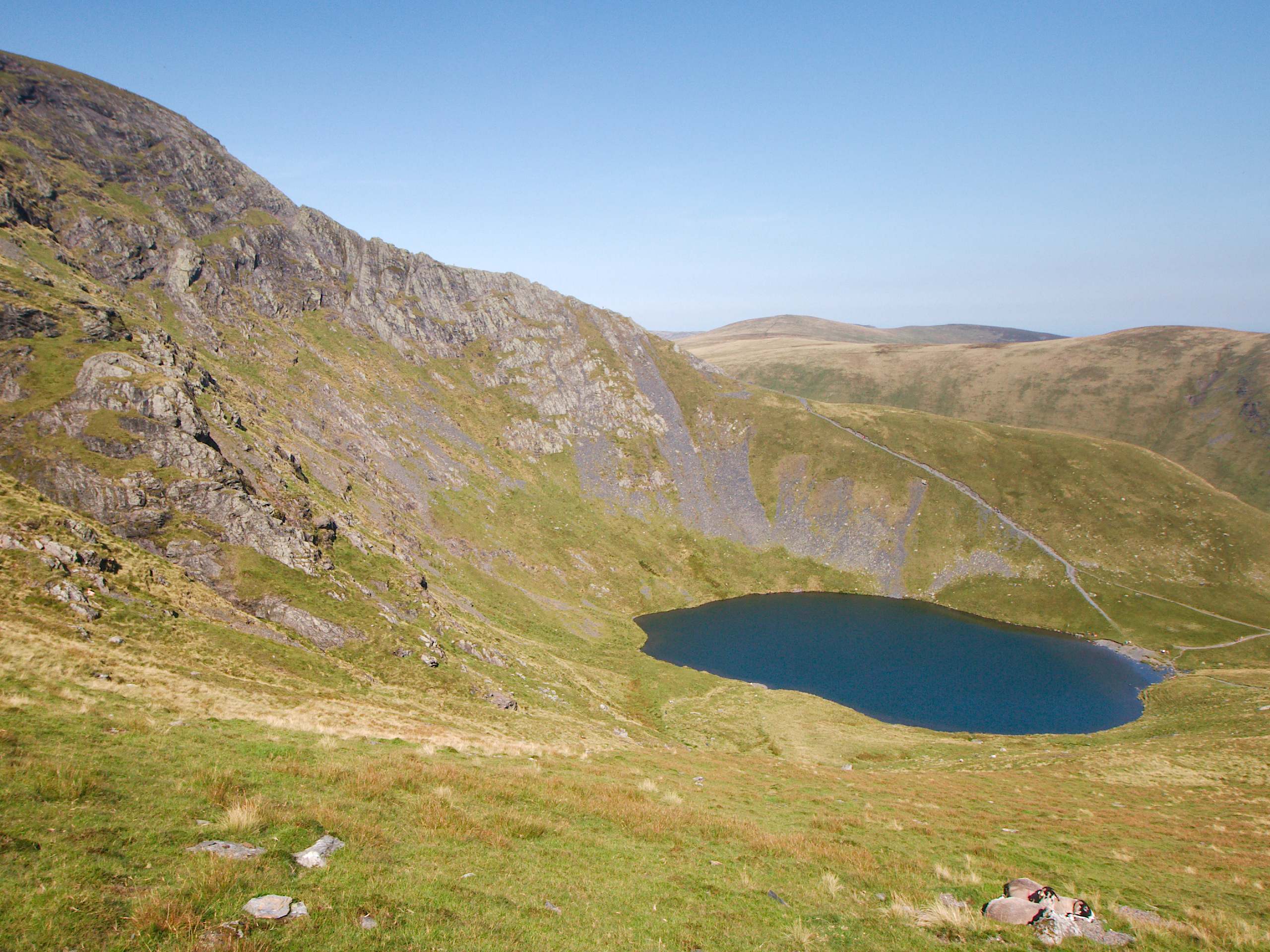
Scales Tarn & Blencathra Circular Walk
Difficulty Rating:
Walking the Scales Tarn & Blencathra Circular is an amazing adventure in the Lake District that will see you traverse some rugged ridgeline terrain for breathtaking views of the surrounding mountainous landscape. While out on the trail, you will climb steeply uphill along Comb Beck and visit the peaceful waters of Scales Tarn before climbing up the aptly named Sharp Edge on the way to the summit viewpoint atop Blencathra. If you enjoy walking along precarious terrain to get some truly gorgeous views, then this walk will be right up your alley.
Getting there
To reach the car park for the Scales Tarn & Blencathra Circular Walk from Keswick, drive east on Penrith Road for 0.8mi and turn left onto Penrith Road/A591. After 0.5mi, merge onto the A66 along the ramp marked Penrith/M6/Low Briery and follow it for 4.2mi. Turn left here onto Scales and continue on for 354ft before making a slight left to arrive at the car park.

About
| When to do | March-October |
| Backcountry Campsites | No |
| Pets allowed | Yes - On Leash |
| Family friendly | No |
| Route Signage | Average |
| Crowd Levels | Moderate |
| Route Type | Lollipop |
Scales Tarn & Blencathra Circular Walk
Elevation Graph
Weather
Scales Tarn & Blencathra Circular Walk Description
The Scales Tarn & Blencathra Circular Walk is a rough and rugged adventure that will expose you to some steep and rocky terrain along Sharp Edge and the summit of Blencathra. Make sure to wear sturdy walking boots and bring poles to both provide stability and save your knees on the lengthy descent of the mountainside. While you could bring a dog on this walk, it is not advised due to the rugged terrain and steep drop offs.
Although this route may be challenging, both the feeling of having completed such a rugged route and the amazing views of the surrounding countryside will leave you in a state of contentment. The trail climbs sharply uphill along the terrain of the moor before breaking to the west to visit the quiet shores of Scales Tarn. From here, you will work your way along the rocky ridgeline known as Sharp Edge before summiting Blencathra for some breathtaking views. Wrap up the adventure with a few pints at the White Horse Inn and you’ll have an amazing day of walking that will leave you feeling accomplished – if a little sore.
Setting out from the car park, turn right along the road and follow it for 0.4mi, turning right to pick up a parth that will take you north alongside Comb Beck. Keep straight for the next 0.7mi, making your way up the steep terrain of the moor until the trail bends to the west and you arrive at a fork. Take the path on the right and keep right for 0.7mi, walking at the foot of the hillside with the River Glenderamackin on your right and Bannerdale Crags to the north.
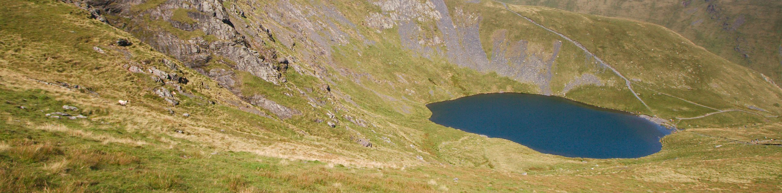
Reaching a series of junctions, keep left and cross over Scales Beck, following the path until you arrive at the peaceful shores of Scales Tarn. Take some time to appreciate the scenic views of the small body of water flanked by the rugged hillside before following the trail north to climb up to Sharp Edge.
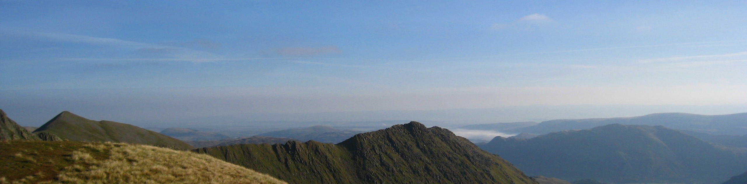
From the tarn, keep left along the trail for the next 0.62mi, climbing up the steep and jagged terrain of Sharp Edge while following the trail as it turns south along the ridge to arrive at a junction. Head right here and continue on to the summit viewpoint atop Blencathra. From this 2848ft perch at the top of the mountain, you will have some amazing views that sweep across the Lake District in every direction that include Skiddaw and Lonscale Fell to the northwest, Keswick to the west, and of course the charming waters of Scales Tarn directly below to the northeast.
After taking in the amazing views, retrace your steps towards Sharp Edge for 454ft and follow the path at the junction that branches off to the right. From here, follow the switchback to begin the descent of the hillside, keeping straight along the trail for 1.0mi to arrive at a fork. Head right and continue down the steep terrain of the mountainside, where you will eventually arrive back in Scales near the car park where you began your adventure. Having wrapped up the Scales Tarn & Blencathra Circular Walk, you can either head home for some much deserved rest or pop into the White Horse Inn for a few celebratory drinks.
Insider Hints
This trail features some rugged terrain with steep drop offs. Wear sturdy walking boots and take your time walking along any challenging terrain.
If you want to extend this walk, continue southwest along the ridgeline for more views overlooking Keswick.
This route can become quite slippery and dangerous when wet. If you are inexperienced at walking in these trail conditions, maybe consider saving this one for a fair weather day.
Similar hikes to the Scales Tarn & Blencathra Circular Walk hike
Nethermost Pike via East Ridge Walk
Walking to Nethermost Pike via East Ridge is a tough climb up several rugged fells that will expose you to…

Hawkshead, Wray Castle, and Windermere Walk
The Hawkshead, Wray Castle, and Windermere Walk is a fantastic journey that will lead you through some picturesque locations that…

Pike of Blisco and Crinkle Crags Walk
The Pike of Blisco and Crinkle Crags Trail is a challenging adventure that will see you climb several rugged peaks…
Comments