Causey Pike Round
View Photos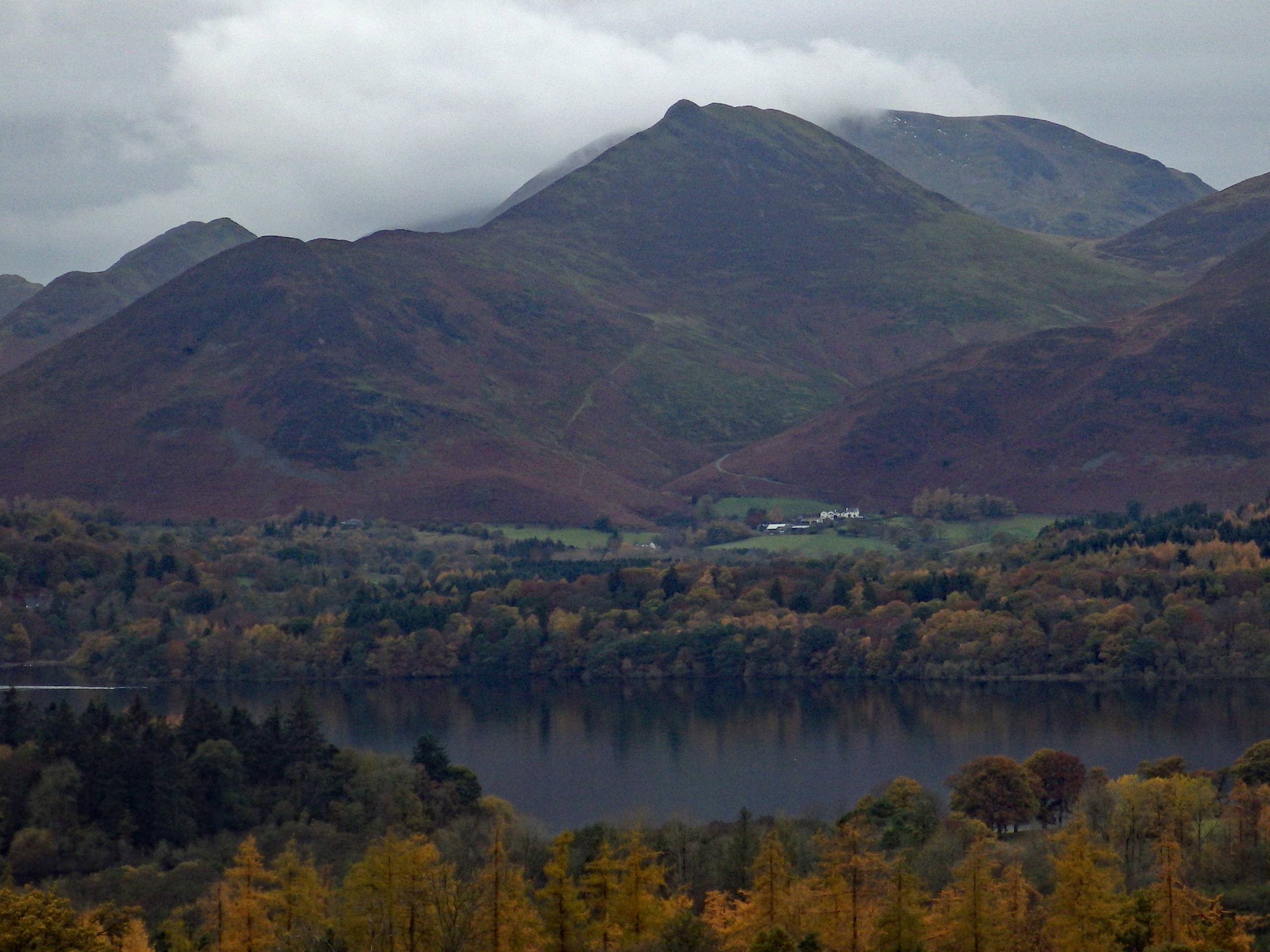
Causey Pike Round
Difficulty Rating:
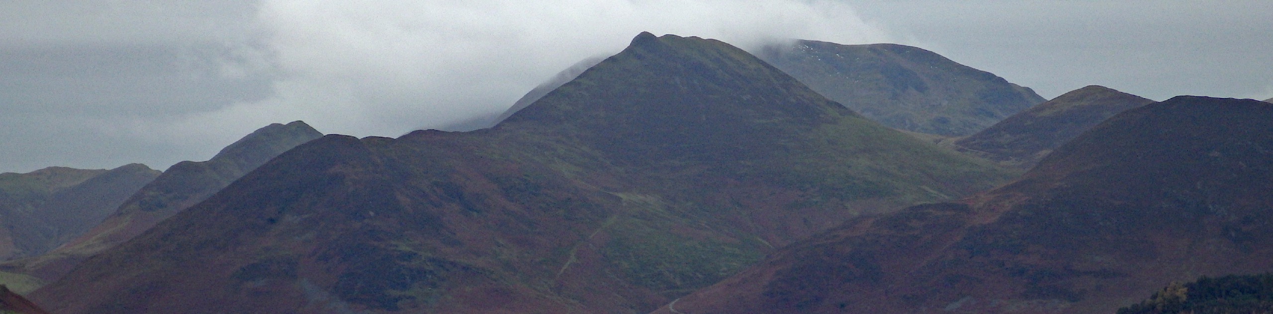
The Causey Pike Round is a challenging Lake District adventure that will take you uphill to the summit of several peaks for views over Derwent Water. The trail sets out from the former mining town of Braithwaite and climbs uphill past the old mines to reach the summit of Causey Pike before descending the hillside towards the lake. This is a great route for those that enjoy a good mix of rugged terrain, local history, and amazing scenery.
Getting there
To reach the trailhead for the Causey Pike Round from Keswick, drive northwest on Main Street for 0.3mi and continue straight onto High Hill/A5271 for another 0.8mi. Turn left here on the A66 and follow it for 1.0mi, making a slight left onto B5292. After 0.3mi, turn right onto Thornthwaite to find an available roadside parking space.

About
| When to do | March-October |
| Backcountry Campsites | Scotgate Holiday Park |
| Pets allowed | Yes - On Leash |
| Family friendly | No |
| Route Signage | Average |
| Crowd Levels | Moderate |
| Route Type | Lollipop |
Causey Pike Round
Elevation Graph
Weather
Causey Pike Round Description
The Causey Pike Round is a fantastic, but at times challenging, walking route that features several ascents and descents along rugged and sometimes boggy terrain. Be sure to wear proper walking footwear if you want to stay comfortable out on the trail. Additionally, parking in the village can sometimes be limited, so try to arrive early.
Even with the leg-burning slopes along this route, you will have an amazing day on the trails that will produce some spectacular views over the Lake District landscape. The trail sets out from the village of Braithwaite and climbs uphill past some old mining operations before traversing a series of rugged summits that include Causey Peak. After taking in the views of Derwent Water and the surrounding area, you will descend the hillside and traverse the open farmland along several winding streams on the return journey back to the village. This route is perfect if you are looking for some amazing views and don’t mind putting in a bit of effort to get them.
Setting out from the roadside parking area opposite St. Herbert’s Church, follow the road southwest until you meet up with the B5292. Cross over to the other side and follow the path through the buildings to meet up with Croft Terrace. Turn right along the road and follow it for 0.1mi, where you will pick up the trail on the right.
Head south along this path for 0.3mi to pass by Braithwaite Lodge Farm and make your way through a series of gates, eventually arriving at a fork in the trail. Keep straight for a short distance and at the next junction follow the path on the right. Here, the slope of the hillside will intensify as you make your way past the old mining operations in the area. Keep straight from the junction for 1.2mi to traverse the summit of Barrow and gain a higher perspective of the surrounding Lake District landscape.
At the fork, head right through the rugged terrain and keep straight through several junctions to climb uphill and arrive at the summit of Stile End. After enjoying the views, follow the path to the west to descend slightly before making the steep climb up Outerside. From here, take the path on the right and follow it for 0.3mi, passing straight through two junctions until you arrive at a third. Go right here and climb uphill along the trail to the southwest for 0.5mi.
Reaching a junction along the ridgeline, head to the left and follow the path as it traverses the summit of Scar Crags on the way to Causey Pike. Once there, you will have an amazing view overlooking Derwent Water to the east and a whole host of peaks to the south and west. After taking in the views, continue east along the ridge for 0.3mi and pick up the trail on the left to make your descent along the hillside.
As you navigate the steep terrain down to Stoneycroft, you will have some great views of the valley stretching out before you. After meeting up with Newlands Hause, head right for a short distance and make a left turn at the fork in the road, following it for 0.3mi to pass through the village of Stair and arrive at a crossing over Newlands Beck. Make your way across and keep left along the road for another 0.2mi.
Pick up the path branching off to the left and follow it through the countryside to the north along the flowing water of Newlands Beck for 1.0mi. Here, you will turn left along the road for 350ft, before turning right along the lane to pass through a series of gates. After this, continue along the track for 0.2mi and turn right to cross over Barrow Gill. From here, you will follow the stream through the open countryside for 0.4mi, bringing you back to the village of Braithwaite where you began the Causey Pike Round.
Insider Hints
The trail can be boggy in some areas and features rugged terrain on the high points of the route. Make sure to wear sturdy walking boots that are ideally waterproof.
The Royal Oak is a great spot near the trailhead for some refreshing post-walk pints.
Similar hikes to the Causey Pike Round hike
Nethermost Pike via East Ridge Walk
Walking to Nethermost Pike via East Ridge is a tough climb up several rugged fells that will expose you to…

Hawkshead, Wray Castle, and Windermere Walk
The Hawkshead, Wray Castle, and Windermere Walk is a fantastic journey that will lead you through some picturesque locations that…

Pike of Blisco and Crinkle Crags Walk
The Pike of Blisco and Crinkle Crags Trail is a challenging adventure that will see you climb several rugged peaks…
Comments