

Coquitlam Crunch Trail
View PhotosCoquitlam Crunch Trail
Difficulty Rating:
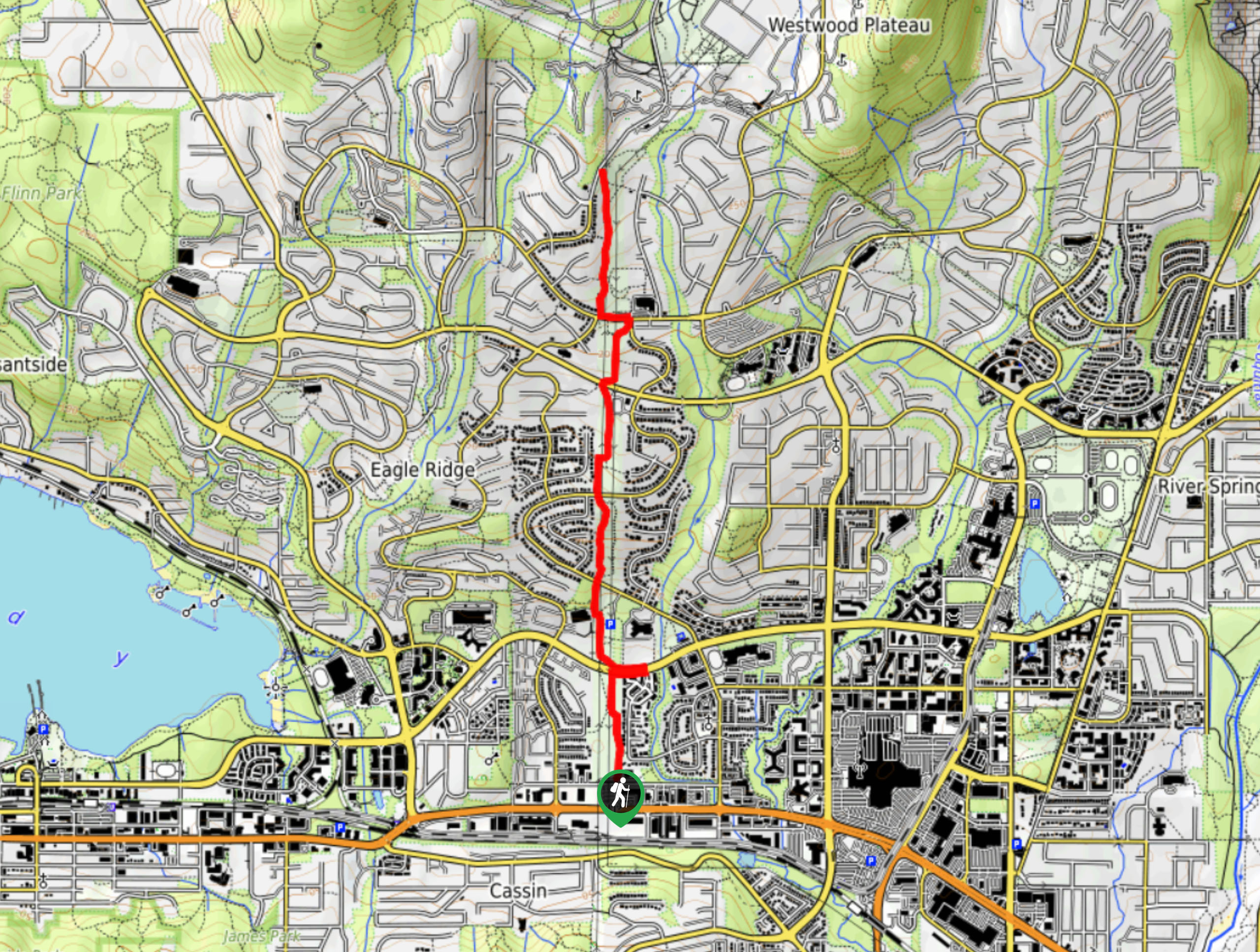
The Coquitlam Crunch Trail is an urban hiking route purposefully designed to provide hikers with an excellent workout. This steeply inclined 3.9mi trail runs underneath a length of hydropower lines and is often considered a less intense version of the Grouse Grind. So while the route may lack beautiful, unobstructed views, you can rest assured that it more than makes up for this shortcoming with an intense workout that will leave you feeling accomplished.
Getting there
To get to the Coquitlam Crunch Trailhead, travel west along Barnet Highway 7A, taking the right exit at Falcon Drive. From here, take the first right onto Runnel Drive. In 820ft, Harrier Park and the Coquitlam Crunch Trailhead, will be on your left-hand side. Parking lots can be found on either side of Runnel Drive.
About
| When to do | Year-Round |
| Backcountry Campsites | No |
| Pets allowed | Yes - On Leash |
| Family friendly | Yes |
| Route Signage | Average |
| Crowd Levels | High |
| Route Type | Out and back |
Coquitlam Crunch Trail
Elevation Graph
Weather
Coquitlam Crunch Trail Description
The Coquitlam Crunch is an urban trail for those looking for a great workout on a steep incline. This heavily trafficked out-and-back runs along a hydropower line and is easily accessible year-round.
From the parking lot on Runnel Drive, follow the trail at its northeast corner as it leads you along the edge of Harrier Park. The path will lead you into the middle of the park before coming up on your first road crossing at Guildford Way. After safely crossing the street, you will see Eagle Ridge elementary school on your left-hand side.
Continue north on the gravel trail, and you will come to the second road crossing at Lansdowne Drive. After crossing the street, you can climb the 437 stairs or continue uphill along the path if you prefer a smoother climb. This section of the trail is the most difficult, as it is rather steep and allows you to gain elevation quickly. As the route begins to level back off and you will approach the next crosswalk, which is a different location on Lansdowne Drive.
Following the second crossing of Lansdowne Drive, the gravel path continues with some staired sections where the path bends to the right and curves back to continue on to the north. From this point, you can take in the best views on the hike as you can see Blue Mountain to the south and Burnaby Mountain behind to the west. Just be careful to step aside and let other hikers pass if you decide to stop for a minute.
Carrying on, the next road crossing is at David Avenue after which the path changes from gravel to a paved trail. Continue past the Bramblewood off-leash dog park, and follow the trail to the left when you reach the junction. Past the basketball court, you will reach the next road crossing at Panorama Drive, marking the last section of the Coquitlam Crunch.
The paved route will continue past Bramblewood Elementary on the right before transitioning to gravel for the final, gradual climb to the top. You can breathe a sigh of relief once you see the sign at Eagle Mountain Drive, which marks the end of the trail. Enjoy the view from the top, and feel the satisfaction of having completed the Coquitlam Crunch before heading back down the trail to the parking lot.
Insider Hints
Stay away from the power lines, as they transmit high-voltage electricity. Avoid this trail altogether during lightning/thunderstorms.
Look out for animals. Although this is an urban hike, the many bushes along the trail are home to animals like raccoons, birds, and coyotes. There are also signs for black bears and cougars, so be mindful of their habitat.
This route has minimal shade, so don’t forget to wear sunscreen and/or cover up with adequate clothing.
This is a highly-trafficked route, so be mindful of other hikers.
Similar hikes to the Coquitlam Crunch Trail hike

Trans Canada and Pandora Trail Loop
The Trans Canada and Pandora Trail Loop is a combination of several trails within the Burnaby Mountain Conservation Area that…

Quarry Trail
The Quarry Trail is a scenic hike through the beautiful wetlands of Minnekhada Regional Park that takes hikers to several…

DeBoville Slough to Addington Lookout
The hike along DeBoville Slough to Addington Marsh is an easy 6.0mi out-and-back trail along a paved path…


Comments