
San Ysidro Creek and Catway Loop
View Photos
San Ysidro Creek and Catway Loop
Difficulty Rating:
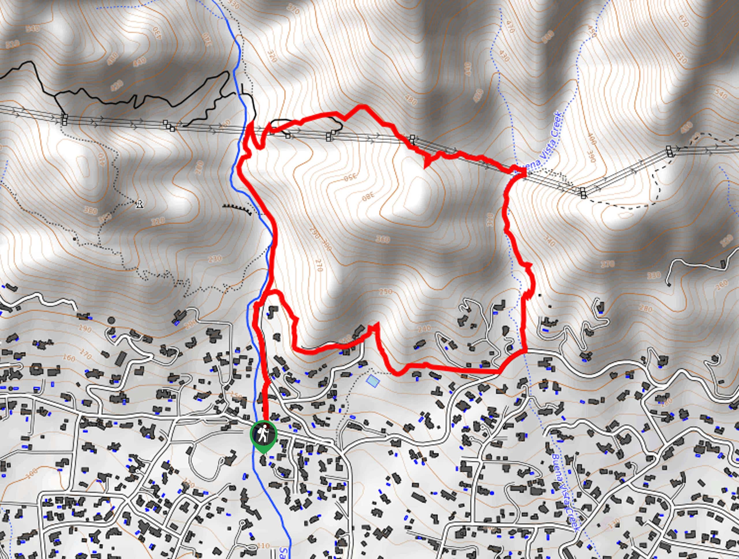
Explore the foothills of the Santa Ynez Mountains along the San Ysidro Creek and Catway Loop. This awesome hike near Montecito is ideal for intermediate hikers and families with older children. Enjoy the scene of the area’s native flora and fauna along this route while getting in a great workout!
Getting there
Access this adventure from the San Ysidro Trailhead off E Mountain Drive.

About
| Backcountry Campground | No |
| When to do | Year-round |
| Pets allowed | Yes - On Leash |
| Family friendly | Older Children only |
| Route Signage | Average |
| Crowd Levels | Moderate |
| Route Type | Lollipop |
San Ysidro Creek and Catway Loop
Elevation Graph
Weather
San Ysidro Creek and Catway Loop Description
Exhibiting the area’s beautiful flora and variety of fauna, this route makes for a scenic adventure. Immerse yourself in the foothills and keep an eye out for lupines, deer, condors, and lizards along the way. Note much of the trail is exposed, so head out early to beat the afternoon heat or wear sunscreen and pack plenty of water! Additionally, this route is flanked with poison oak, so mind your surroundings, and if you are nervous about exposure then wear long pants!
Your journey along the San Ysidro and Catway Loop departs from the San Ysidro Trailhead off E Mountain Drive. Setting out from here you will be led north running parallel to W Park Lane to the true trailhead. From here, veer right and you will be diverted onto the Old Pueblo Trail, heading eastwardly through a more residential area. At the trail’s end, merge onto Park Lane briefly before turning left up the Buena Vista Trail. This route hugs the curves of the meandering Buena Vista Creek, up to the next junction. Here, turn left onto the Edison Catway Trail.
This route will guide you up to an amazing overlook of Santa Barbara in the foreground of the Pacific. Revel in the views, then continue hiking west back down to the San Ysidro Trail. Here, turn left and wander the San Ysidro Trail along the creek and back to the trailhead.
Similar hikes to the San Ysidro Creek and Catway Loop hike
Last Chance Trail
The Last Chance Trail is an amazing adventure through the Santa Paula Canyon amongst the Topatopa Mountains. Indulge in the…
Grass Mountain Trail
The Grass Mountain Trail is an amazing adventure in the Los Padres National Forest that boasts commanding vistas of the…
Brazil Ranch Trail
The Brazil Ranch Trail is an amazing adventure in the Los Padres National Forest that is sure to impress. Walk…
Comments