

Mount Sutro to Twin Peaks Hike
View PhotosMount Sutro to Twin Peaks Hike
Difficulty Rating:
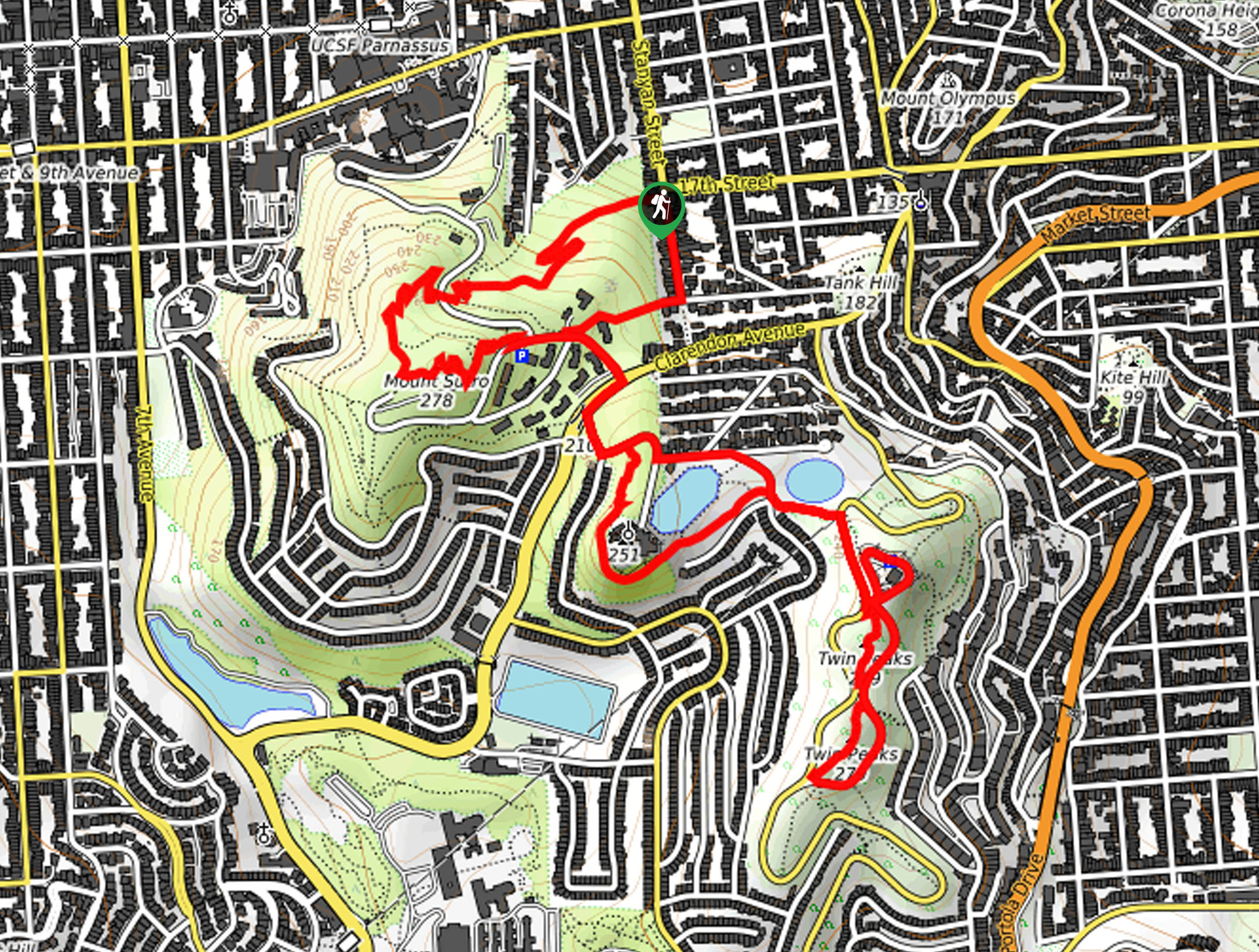
Located in an urban setting, the Mount Sutro to Twin Peaks Hike offers the opportunity to escape the chaos of the city and reconnect with nature in the greenspaces. Wander through mixed woodlands and flowering meadows along the hilly terrain, reveling in the epic views of the cityscape.
Getting there
Access this hike via the Historic Trailhead off Stanyan Street.
About
| Backcountry Campground | No |
| When to do | Year-round |
| Pets allowed | Yes - On Leash |
| Family friendly | Older Children only |
| Route Signage | Average |
| Crowd Levels | Moderate |
| Route Type | Lollipop |
Mount Sutro to Twin Peaks Hike
Elevation Graph
Weather
Mount Sutro to Twin Peaks Hike Description
Indulge yourself with breathtaking views of San Francisco and the area’s notable landmarks along the Mount Sutro to Twin Peaks Hike. This epic excursion is sure to impress with its unparalleled scenery and hilly terrain. Though popular, this route is poorly signposted in areas, so we encourage the use of the trail GPS. Additionally, this route travels along the roadway in areas, maintain the sideway when possible.
Setting out from the trailhead, follow the Historic Trail westwardly, merging onto the North Ridge Trail at the intersection. This route will lead you up to the summit of Mount Sutro, which offers incredible views of the cityscape and the Twin Peaks. From here, follow the East Ridge Trail down to Johnstone Drive and across Clarendon Ave. Wander along Dellbrook Ave, merging onto Sutro Tower Trail, then onto the Twin Peaks Connector Trail and Twin Peaks Blvd. Using the trail GPS, loop around Christmas Tree Point Road and along the eastern slopes of the Twin Peaks.
At the path’s end, climb up the stairs to the summit of the Twin Peaks, reveling in the unrivaled scenery. From here, head back down the path, retracing your steps along the Twin Peaks Connector Trail, hooking onto Marview Way and left onto Palo Alto Ave. Connect with La Avanzada Street, retracing your steps across Clarendon Ave. From here, use the trail GPS and wander along Stanyan Street back to the trailhead.
Similar hikes to the Mount Sutro to Twin Peaks Hike hike

Bridge to Nowhere via East Fork Trail
The hike to the Bridge to Nowhere via East Fork Trail is a fun little adventure in the Angeles National…

Echo Mountain via Sam Merrill Trail
The Echo Mountain via Sam Merrill Trail is a beautifully scenic adventure in the Angeles National Forest of Southern California…

Lewis Falls Trail
Hiking the Lewis Falls Trail is a spectacular, if fairly short, adventure in the Angeles National Forest that will take…


Comments