

Lake Crescent via Spruce Railroad Trail
View PhotosLake Crescent via Spruce Railroad Trail
Difficulty Rating:
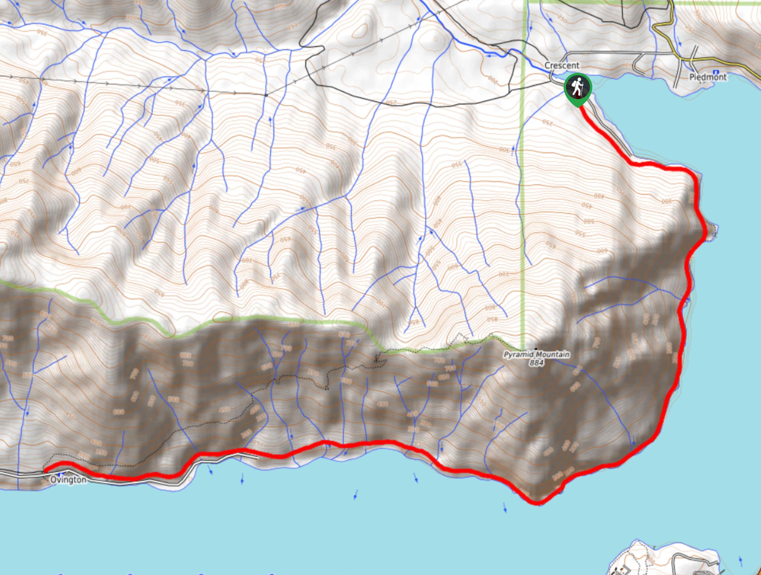
The hike on Spruce Railroad Trail alongside Lake Crescent is a wonderful trip that’s perfect for families with its opportunities to swim and explore old railway tunnels. This hike follows part of the expansive Olympic Discovery Trail, a bike and hike route across the northern Olympic Peninsula. You’ll pass a great campsite, the gorgeous Devil’s Punchbowl, and an old railway tunnel before turning around at Ovington.
This hike is pleasant year-round, but it’s our favorite in the summertime when you can stop into the punchbowl for a swim.
Getting there
The trailhead for the Lake Crescent hike via Spruce Railroad Trail is on E Beach Road prior to the road’s end.
About
| Backcountry Campground | Various sites |
| When to do | Year-round |
| Pets allowed | Yes - On Leash |
| Family friendly | Yes |
| Route Signage | Good |
| Crowd Levels | Moderate |
| Route Type | Out and back |
Lake Crescent via Spruce Railroad Trail
Elevation Graph
Weather
Lake Crescent via Spruce Railroad Trail Description
Lake Crescent is best explored and appreciated on the Spruce Railroad Trail, which navigates the northern shore of this deep blue lake. The hike to it on Spruce Railroad Trail is a great family adventure, with a very easy path meandering alongside the shore of this wide blue lake. It’s a very easy hike, but it can also be extended quite far on the same trail if you want to add some distance to your day. Highlights include Devil’s Punchbowl and an old railway tunnel.
You can enjoy this hike year-round, and we love seeing the different character of Lake Crescent in different months and different weather. You’ll be hiking on a paved path with even footing the entire way.
The hike begins in an old orchard of maple trees dressed in green moss. Walk through the orchard and then head to the old railroad path that winds alongside the lakeshore. This railroad was previously used to haul Sitka spruce trees from the forest. You can probably see where the trail got its name from!
The lumber was originally destined to be used in the manufacture of aircraft in World War I. The logs instead ended up being used for commercial logging for four decades. When its logging days were done, the National Park Service stepped in to repurpose the area, creating the hiking trail you’re on.
As you hike through towering maple, Sitka spruce, hemlock, and many other kinds of trees, enjoy the sound of the lake nearby. Take your time on this beautiful stretch.
You’ll be both near the shore and higher up from the water on this route, so feel free to dip down to the water where beach access is possible. When you’re further above the shore, enjoy the vantage point you’ll have across the water.
One mile from the trailhead, a bridge reaches over a section of the lake. The Devil’s Punchbowl is on the right here. It’s a beautiful calm pool of deep blue, the perfect place to grab a few photos or hop in. From here, wrap around the point with Pyramid Mountain to your right, continuing to the old railway tunnel. This spooky spot is sure to be a favorite for kids. The Lake Crescent Lodge is across the water from you here.
Through the tunnel, keep walking along the shore. The route ends at Ovington, but the trail itself goes a bit further if you want to keep exploring. Otherwise, head back to the trailhead by retracing your steps.
Insider Hints
There is cliff jumping available near the punchbowl for thrill-seekers.
There is no pass or permit required for this trail.
Dogs are allowed on this hike but remember to keep them on-leash.
Similar hikes to the Lake Crescent via Spruce Railroad Trail hike

West Elwha River Trail
The West Elwha River Trail is a lovely moderate walk alongside the river to the Altair Campground and back. This…

Humes Ranch Loop Trail
Humes Ranch Loop Trail is a heavily trafficked loop hike in Olympic National Park. This trail is very beautiful and…

Mount Angeles via Switchback Trail
Mount Angeles via Switchback Trail is an exciting hike that starts out more gradual before ending with a fairly demanding…


Comments