

Sugarloaf Mountain Hike
View PhotosSugarloaf Mountain Hike
Difficulty Rating:
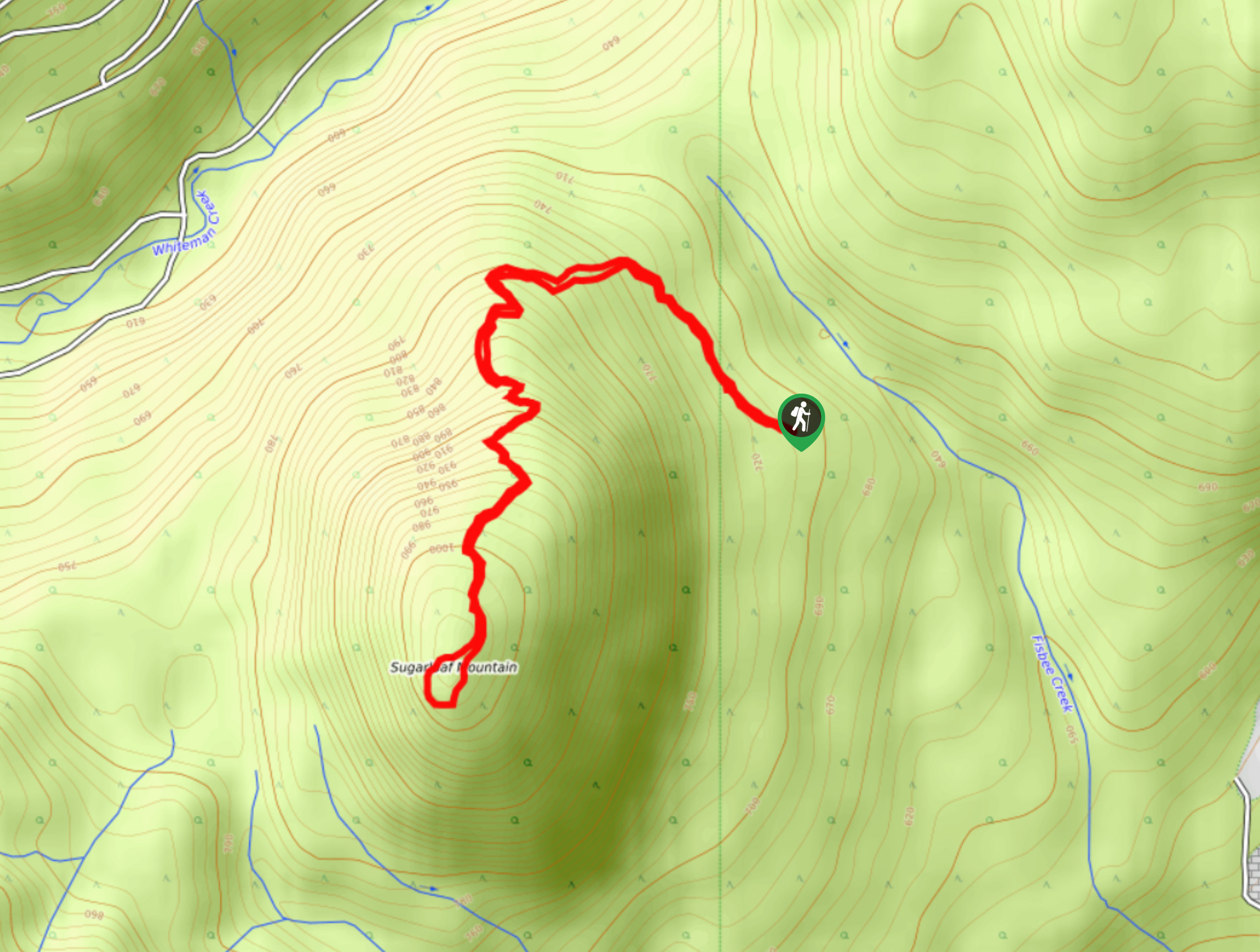
Not many tourists know about the Sugarloaf Mountain Hike, making it a phenomenal, quiet hiking option for anyone seeking a scenic, secluded walk to an overlook of the shimmering Okanagan Lake and the valley sprawled below. Even though we’re bringing this hike to light now, we bet that you still won’t encounter a lot of people on the trail!
Getting there
To get to the Sugarloaf Mountain Hike from Vernon, BC, drive towards Highway 97 N. Turn right at Highway 97 N to Kamloops. Continue for 3.5mi before turning left to stay on Highway 97 N. After 11.7mi, turn left onto Westside Road. After around 14.3mi, turn right at the Evely Recreation Site. Continue along this road, past gravel pits. You should see a sign for Sugarloaf Trailhead 2.3mi into Westside Road.
About
| When to do | April - October |
| Backcountry Campsites | No |
| Pets allowed | Yes - On Leash |
| Family friendly | Older Children only |
| Route Signage | Average |
| Crowd Levels | Low |
| Route Type | Lollipop |
Sugarloaf Mountain Hike
Elevation Graph
Weather
Sugarloaf Mountain Hike Description
The Sugarloaf Mountain Hike sits between Vernon and Kelowna, making it a great go-to scenic exercise for locals and visitors seeking a change of scenery. It’s vital to know that the road can be a bit tough in wet conditions. You’ll go past gravel pits before reaching a rough, rocky road with potholes and big rocks, so driving in your car may not be the best option. This route also has a steady, steep ascent—don’t let the short distance deceive you into thinking it’ll be super easy.
However, once you hit the trail, you’ll have no problem navigating your way to the pinnacle. The path is easy to follow and not technical. It’s a great route to get your heart rate up in a short amount of time! At the top, you’ll get the chance to marvel at sprawling views of the valley and the glistening Okanagan Lake below.
The path leading to the trailhead is straightforward, so you won’t have to worry about confusing junctions or getting lost. When you reach the peak of Sugarloaf Mountain, you’ll follow a little loop, stopping at a collection of different viewpoints before turning around and following the path before the mini circuit back to the parking lot.
Trail Highlights
Frequently Asked Questions
Can I reach the trailhead in my car?
It can be a bit rocky and rough for a car to reach the trailhead, so you may better off with a 4×4. However, if the conditions are dry, you may be able to get away with driving your car.
What’s the nearest campsite to Sugarloaf Mountain?
You can camp at Evely Campground, located along Okanagan Lake, which is just a 15-minute drive away from the trailhead. There’s no potable water here!
Insider Hints
Bring bug spray if you’re hiking during warmer months!
You’ll likely find wildflowers blanketing the scenery if you do this hike in May.
Similar hikes to the Sugarloaf Mountain Hike hike
Okanagan Mountain Hike
The Okanagan Mountain Hike is an incredible backcountry hike that gets your heart pumping, unveiling a reel of views en…
Glen Canyon Greenway Trail
The Glen Canyon Greenway Trail, located in West Kelowna, is a family-friendly hike that blends flat, easy-going terrain with more…
Blue Grouse Mountain Hike
The Blue Grouse Mountain Hike near Kelowna, BC, is a challenging hike that carries you up a steep ascent to…


Comments