Mori Point Loop Trail
View Photos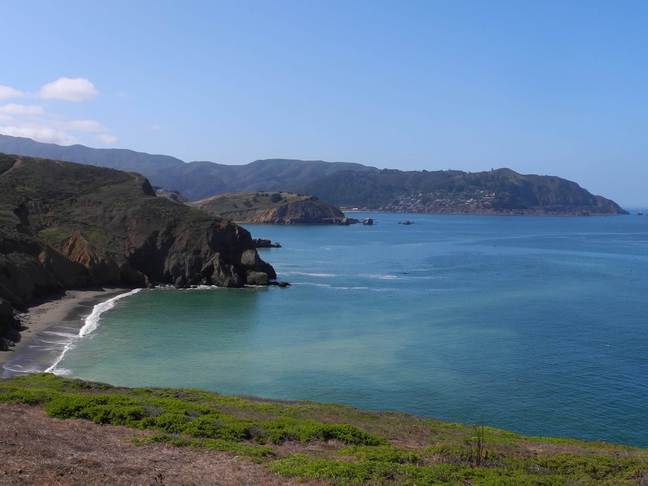
Mori Point Loop Trail
Difficulty Rating:
The Mori Point Loop Trail, located in the Golden Gate Recreation Area, is an excellent adventure ideal for hikers of all skill levels and ages—including your four-legged friend! Explore the lush coastal headlands decorated with vibrant wildflowers and marvel at the gorgeous maritime scenery.
Getting there
The Mori Point Loop Trail is accessed via the parking lot and trailhead off Scott Lane.

About
| Backcountry Campground | No |
| When to do | Year-round |
| Pets allowed | Yes - On Leash |
| Family friendly | Yes |
| Route Signage | Poor |
| Crowd Levels | Extreme |
| Route Type | Lollipop |
Mori Point Loop Trail
Elevation Graph
Weather
Mori Point Loop Trail Description
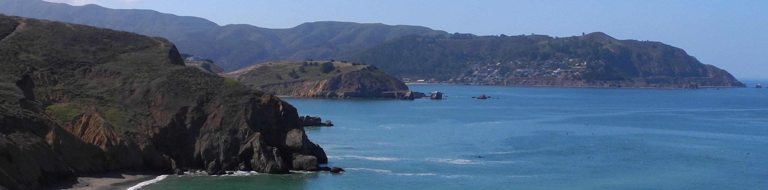
The Mori Point Loop Trail is a wonderful trail near San Francisco that boasts the perfect opportunity for a picnic overlooking the ocean. Wander atop the shoreline cliffs that tower hundreds of feet above the surging surf and get a wonderful workout-in! Due to its proximity to the ocean, this trail sees extreme conditions—notably wind and thick fog—so we encourage hikers to dress in layers as insurance against chilly conditions! Additionally, it is important to maintain the established path as the headlands are fragile, and poison oak flanks the path. Finally, note this route is well revered, so head out in the early morning for a more tranquil experience.
Those seeking a scenic shoreline stroll near the Bay Area will undoubtedly enjoy the Mori Point Loop Hike. This popular expedition travels through a beautiful piece of coastal terrain maintained by the National Park Service, which perseveres the delicate bluffs, lush headlands, and pristine beaches. Revel in the marvelous views of the dramatic coastline, the Farallon Islands, and, if you are lucky—the sights of migrating whales. Immerse yourself in the California coastal prairies and shrubs abundant with wildflowers. The next time you find yourself in the Bay Area, be sure to take a trip out to Mori Point.
Embark on your adventure along the Mori Point Loop Trail from the trailhead off Scott’s Lane. Setting out from here, you will wander northwest through Mike’s Garden. The right side of the path is bound by lush conifers, and on the left, coastal prairies. Eventually, you will reach an intersection, veer right, intersecting with Calera Creek. After crossing the creek, take the leftmost path, transitioning off the paved path, weaving through the grasslands and down towards Rockaway Beach. If time permits, head down and explore the pristine beach. Continue north, tracing the edge of the coastal headlands, merging onto the Bluff Trail. As you track the undulating route north, the path will travel through some overgrowth before confronting a junction.
At this point, veer left, and you will be diverted onto the Headland Trail, hiking out to the observation overlook. Marvel in the beauty of the maritime panorama and the views of the Pacifica Pier and sandy beaches in the north. After admiring the scenery, retrace your footing back to the intersection, merging onto the Coastal Trail. Ironically, this route travels inland, away from the seaside cliffs, and into the wildflower abundant prairies. At the following intersection, hook onto the Lishumsha Trail and onto the Upper Mori Trail—which runs parallel to the north face of Mori Ridge. At the route’s end, turn right onto the Timigtac Trail and left at the next juncture onto an unnamed path that will ultimately deliver you back to the trailhead.
Frequently Asked Questions
How long is the Mori Point Loop Trail?
The Mori Point Loop Trail is a 2.5mi hike in the Golden Gate National Recreation Area.
Are dogs allowed at Mori Point?
Yes, dogs are permitted on Mori Point and along the Mori Point Loop Trail.
How much does it cost to visit Mori Point?
There are no fees required to visit Mori Point.
Insider Hints
Wear a windbreaker—it is often extremely windy here
Maintain on the marked path, the shoreline cliffs are delicate and can easily breakaway
Charge your camera, the scenery is picture-perfect
Head out on a clear day to enjoy the best scenery
Visit in the morning to secure a parking spot in the limited car park
Similar hikes to the Mori Point Loop Trail hike

Bridge to Nowhere via East Fork Trail
The hike to the Bridge to Nowhere via East Fork Trail is a fun little adventure in the Angeles National…
Echo Mountain via Sam Merrill Trail
The Echo Mountain via Sam Merrill Trail is a beautifully scenic adventure in the Angeles National Forest of Southern California…
Lewis Falls Trail
Hiking the Lewis Falls Trail is a spectacular, if fairly short, adventure in the Angeles National Forest that will take…
Comments