

Barn Trail to Cal Neva Loop
View PhotosBarn Trail to Cal Neva Loop
Difficulty Rating:
The Barn Trail to Cal Neva Loop is an incredible adventure that weaves between the state line of California and Nevada, boasting jaw-dropping panoramas of Lake Tahoe and the bounding Sierra Nevada snow-capped mountains. Marvel in the beauty of the surrounding dramatic landscape as you get your rate up, hiking the Barn Trail to Cal Neva Loop.
Getting there
The Barn Trail to Cal Neva Loop departs from the Barn Trail Parking Lot off S Administrative Road.
About
| Backcountry Campground | No |
| When to do | Year-round |
| Pets allowed | Yes - On Leash |
| Family friendly | Yes |
| Route Signage | Good |
| Crowd Levels | Moderate |
| Route Type | Lollipop |
Barn Trail to Cal Neva Loop
Elevation Graph
Weather
Barn Trail to Cal Neva Loop Description
Immerse yourself in the high country along the Barn Trail to Cal Neva Loop. This wonderful alpine adventure packs the perfect ratio of scenery and strenuosity. Offering a diversity of views and traveling over a variety of terrain, this route demands some stamina and concentration. Though charming, the granite outcrops that adorn the path have been known to cause the odd rolled ankle, so wear sturdy footwear and mind your footing! Additionally, much of the path is exposed, dress in layers as insurance against changing conditions, and wear sun protection in the summer! It is important to be mindful of wildlife as you walk—consider wearing a bear bell.
Indulge yourself with epic views of the shimmering alpine Lake Tahoe and the craggy summits that flank the waters. The Barn Trail to Cal Neva Loop is a great adventure for those seeking a more relaxing, less arduous trek than the Van Sickle Rim Trail Connector. Whether you are a hiker, runner, snowshoer, or mountain biker, you can enjoy this scenic route year-round. Traveling through mixed pines, red firs, junipers, and granite outcrops, the diversity of the terrain will stimulate your sense—not to mention the sweeping vistas of the encompassing mountainous landscape. Additionally, much of the route meanders beneath a gondola—if you have time after your hike, why not take a trip up to the summit of East Peak? We love this epic excursion, and though we try our best, our descriptions cannot live up to the real thing—so you’ll just have to try it out yourself.
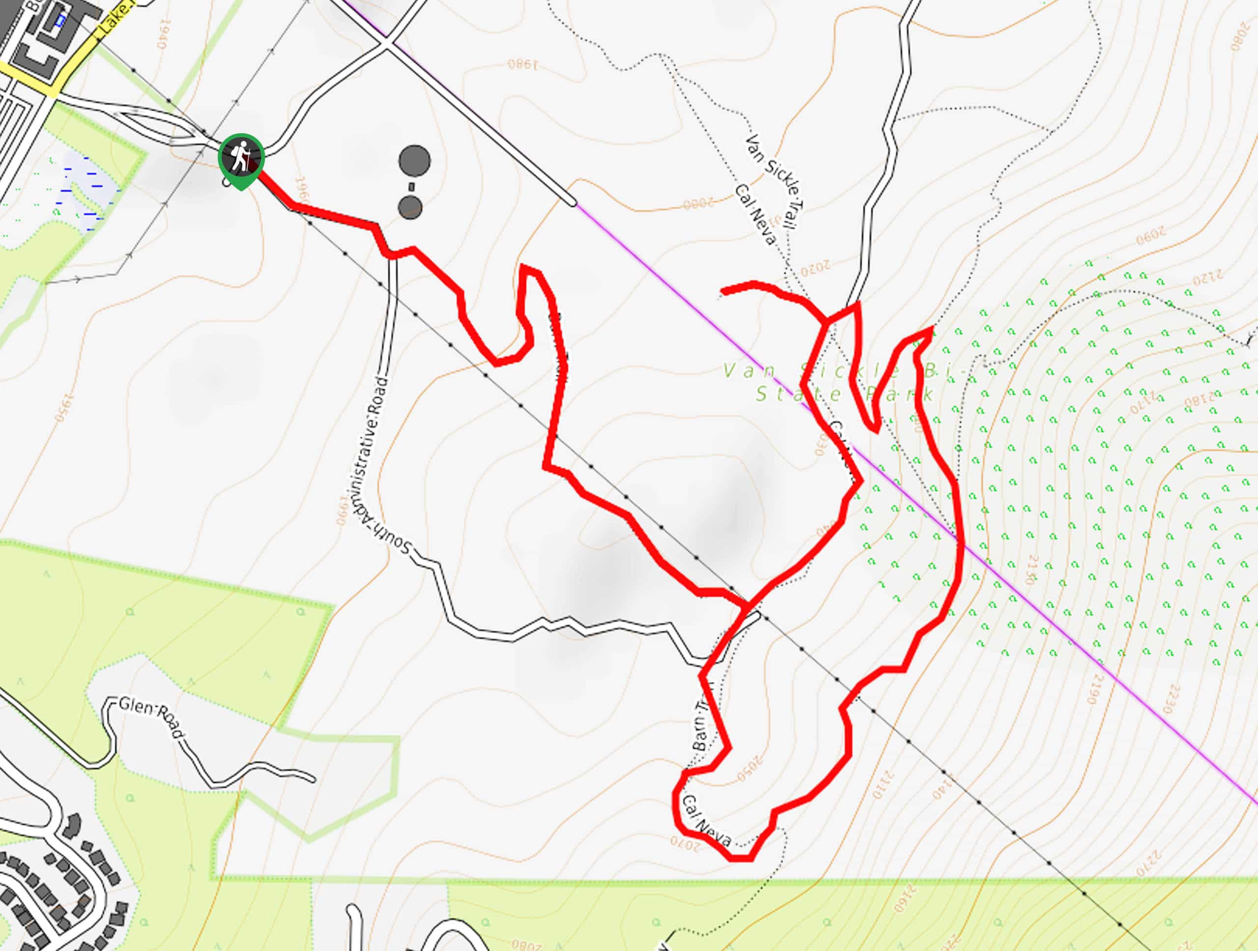
Setting out from the parking lot off S Administrative Road, the Barn Trail to Cal Neva Loop travels southeast along the road before reaching the Barn Trailhead. From here, the winding route travels through the mixed woodlands adorned with granite outcrops. The trail will gradually level out, running beneath the Heavenly Gondola to the route’s end. Here, veer right, walking briefly along the S Administrative Road before hooking onto the Cal Neva Trail. Now trekking south up the granite terrain, you will be diverted northeast along the mountainside, which boasts panoramic views of the surrounding forestlands and South Lake Tahoe below.
Again, you will pass beneath Heavenly Gondola before crossing the state line into Nevada; welcome to the Sagebrush State! Soon after crossing the border, you will encounter yet another junction. Turn left here onto the Van Sickle Trail. Navigate a pair of switchbacks down the path sparsely decorated with pines to the scenic overlook. Marvel in the postcard-perfect panoramas of Lake Tahoe below and the snow-capped Sierra Nevada summits. After reveling in the views, track south along the Cal Neva Trail back into California and under the gondola. Soon you will reach the Barn Trail intersection. Here, veer right and retrace your steps down this path back to the trailhead, then onto the parking lot.
Frequently Asked Questions
Where do you park when hiking the Barn Trail to Cal Neva Loop?
Those hiking the Barn Trail to Cal Neva Loop will need to park at the bottom of S Administrative Road and walk along the shoulder of the road to the trailhead.
How long is the Barn Trail to Cal Neva Loop?
The Barn Trail to Cal Neva Loop is a 2.9mi hike near South Lake Tahoe.
Insider Hints
This trail is an epic snowshoeing route in the winter months
Bring a camera, the views from the scenic overlook are unparalleled
Pack plenty of water, much of the terrain is exposed
If you are seeking a longer trek, then venture the Van Sickle Trail!
Similar hikes to the Barn Trail to Cal Neva Loop hike

Red Lake, Frog Lake and Carson Pass Hike
Seeking a day hike away from the crowds of Lake Tahoe? The Lake, Frog Lake and Carson Pass Hike is…

Winnemucca and Round Top Lakes Hike
The Winnemucca and Round Top Lake Hike is an awesome adventure in the Mokelumne Wilderness. Wander through mixed pine forests…

Squaw Creek to Shirley Canyon Hike
The Squaw Creek to Shirley Canyon Hike is a must-add to your hiking itinerary. Located near Olympic Valley, this route…


Comments