
Castleton Tower Trail
View Photos
Castleton Tower Trail
Difficulty Rating:
The Castleton Tower Trail is a short but challenging hike to the incredible Castleton Tower Rock formation. This trail is most often used as an access trail for rock climbers who are looking to ascend this impressive spire. This trail, however, does make a great hike to an epic sandstone formation just outside of Arches National Park.
Getting there
Turn up highway 128 from highway 191 just northwest of Moab. Follow highway 128 for 15.5mi along the Colorado River. After 15.5mi, take a right onto La Sal Mountain Loop Road. Follow this road for 4.7mi to the small camping area on the north side of the road. Park at the campground, the Castleton Tower Trail begins here.

About
| Backcountry Campground | Camping near trailhead |
| When to do | Year-round |
| Pets allowed | Yes |
| Family friendly | No |
| Route Signage | Average |
| Crowd Levels | Low |
| Route Type | Out and back |
Castleton Tower Trail
Elevation Graph
Weather
Castleton Tower Trail Description
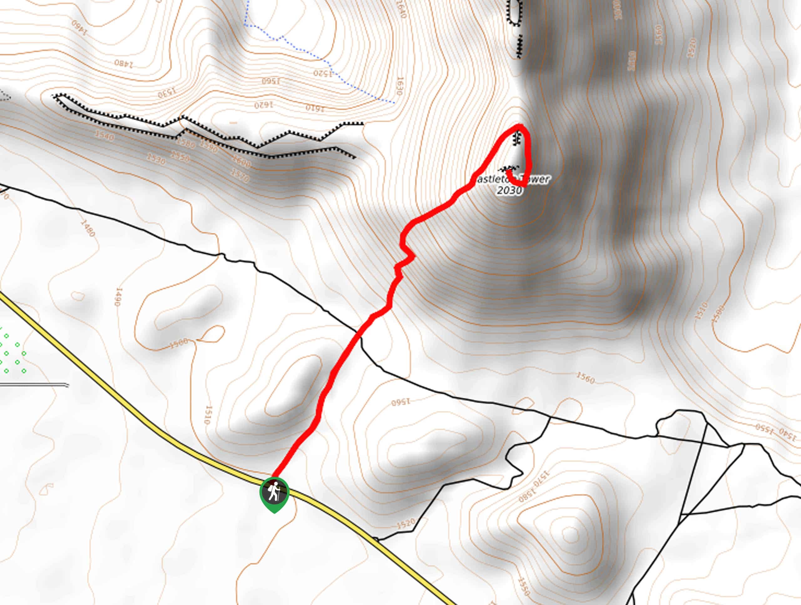
The hike to Castleton Tower is a short but steep trail up to an impressive geological structure just outside of Moab. This hike is challenging and should only be done by experienced hikers in good physical condition. Proper footwear and lots of water is essential for this trail, we also recommend bringing along a set of hiking poles to aid in the ascent and descent.
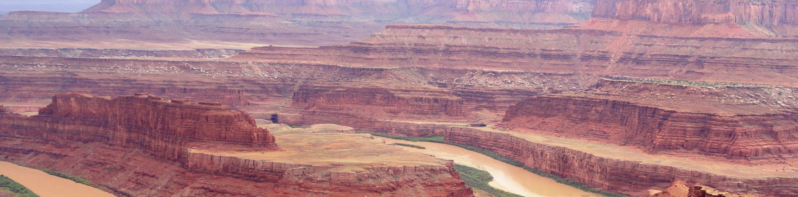
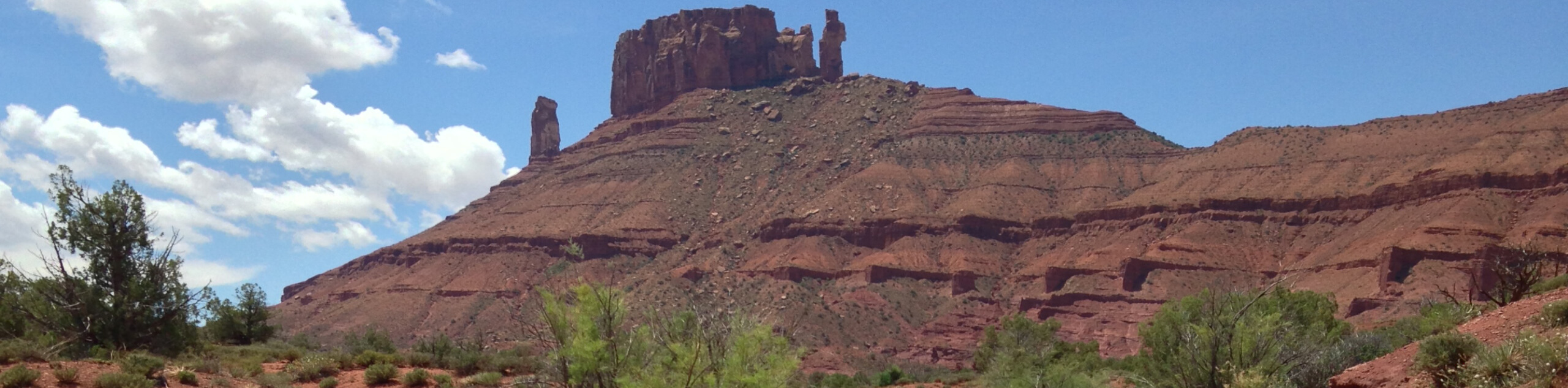
This trail makes up for the effort with stunning views. This unique tower is an imposing presence in Castle Valley and is a cool contrast to the more popular arch formations of the area. This hike is primarily used as an access route for people looking to climb Castleton tower, so keep an eye out for these adventurous folks on the trail and wish them luck. When you are at the base of the tower, look up and see if you can spot climbers making their way up this sandstone structure. Be mindful of rockfall they may send down as they make their way up the Castleton Tower.
From the small camping area, hike up the wash heading northeast. Follow the cairns that mark the trail until you reach a dirt road. Cross the road, and look for the signpost that points you in the right direction of the Castleton Tower. From here, the trail will get steeper and steeper as you near the tower itself.
Just over a mile past the road you will arrive at the base of Castleton Tower. Take a rest here, and admire the impressive stance of this sandstone spire. When you’re ready to turn back, just follow the same path back to the parking lot.
Trail Highlights
The Castleton Tower
At just under 1500ft, Castleton Tower is one of the most famous desert towers in the world and a sought-out destination for rock climbers from all over the planet. This tower features some of the best rock climbing in North America. Look for climbers making their way up this impressive structure when you are on your hike.
Frequently Asked Questions
Why is Castleton Tower Famous?
Castleton Tower is most famous for its world-renowned climbing routes. The Kor-Ingalls Route (5.9, trad) is featured in the book Fifty Classic Climbs of North America.
What type of rock is Castleton Tower?
Castleton Tower is formed of Wingate Sandstone on top of a Moenkopi-Chinle cone.
Insider Hints
This trail is steep and loose, wear proper footwear and take your time on the descent
If you’re looking for a scenic place to spend the night, this trail has a small, free campground at the trailhead.
Bring a camera with you! This trail is jaw-droppingly gorgeous.
Similar hikes to the Castleton Tower Trail hike
Dead Horse Rim Loop and Big Horn Overlook Trail
The Dead Horse Rim Loop and Big Horn Overlook Trail is a fantastic day-hike in the southern section of Dead…
Klondike Bluff Outer Loop
The Klondike Bluffs Outer Loop is a great low-traffic trail just outside of Arches National Park. This route is primarily…
Sylvester Trail
The Sylvester Trail is a moderately challenging route with beautiful views of the Utah desert. This hike gets relatively low…
Comments