

Rostrevor Forest and Slievebane Circular Walk
View PhotosRostrevor Forest and Slievebane Circular Walk
Difficulty Rating:
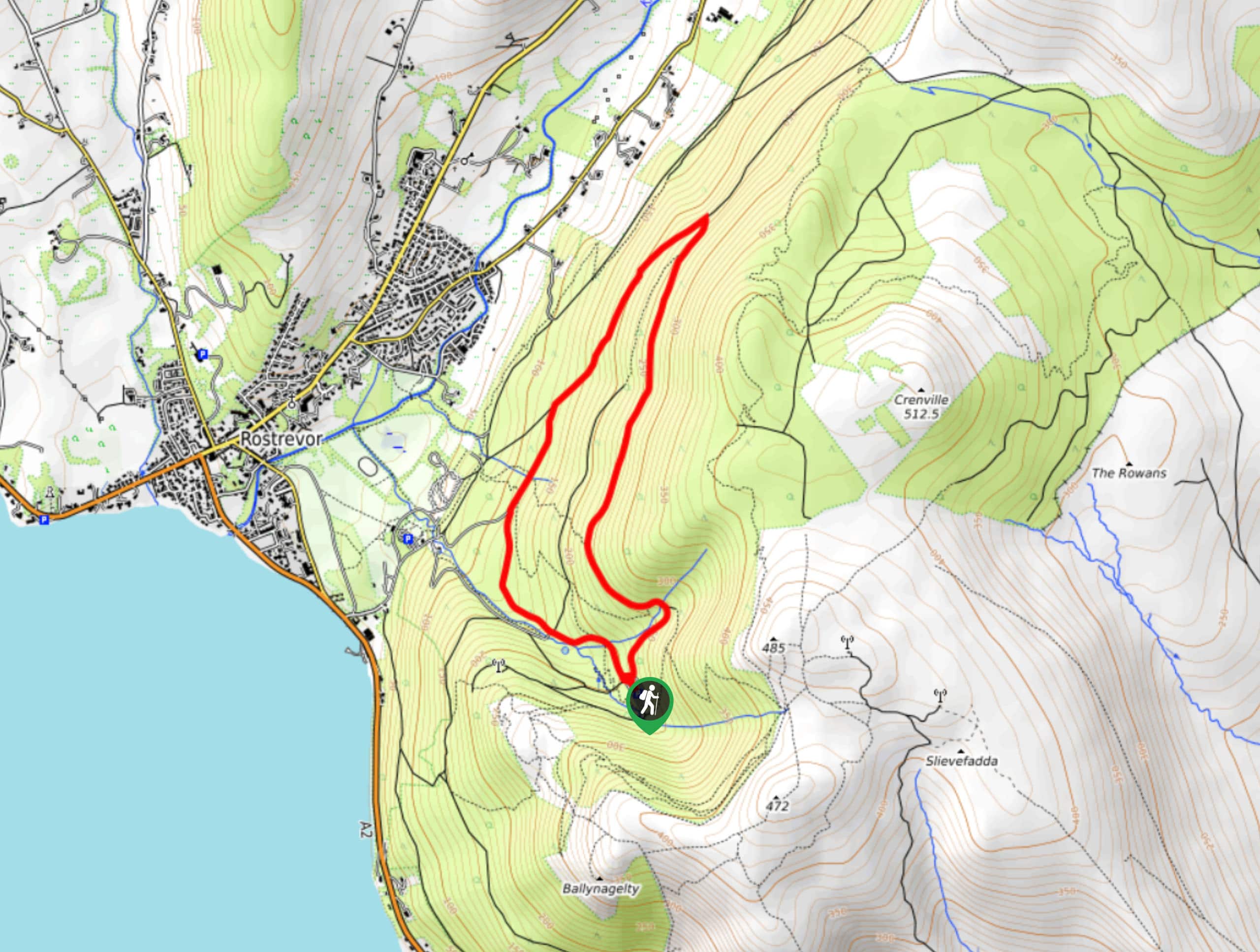
The Rostrevor Forest and Slievebane Circular Walk is a fun woodland adventure that features a good amount of elevation gain and some nice views through the tree cover. While out walking the trail, you will make your way through the tranquil expanse of Rostrevor Forest, climbing up the hillside for some nice views of the nearby glacial fjord of Carlingford Lough. This trail isn’t overly long, but there are some challenging sections that will be sure to make you break a sweat.
Getting there
The trailhead for the Rostrevor Forest and Slievebane Circular Walk can be found southeast of Rostrevor, next to the car park that is 0.8mi southeast of the Cloughmore Centre.
About
| Backcountry Campground | No |
| When to do | April-September |
| Pets allowed | Yes - On Leash |
| Family friendly | Older Children only |
| Route Signage | Average |
| Crowd Levels | Moderate |
| Route Type | Circuit |
Rostrevor Forest and Slievebane Circular Walk
Elevation Graph
Weather
Rostrevor Forest and Slievebane Circular Walk Description
While the Rostrevor Forest and Slievebane Circular Walk isn’t an overly difficult trail, there is a moderate amount of elevation gain and a few sections that will provide a bit of a challenge. Be sure to wear sturdy walking boots in order to stay comfortable along the route. Additionally, make sure to respect other walkers in the area and keep your dog on a leash.
If you enjoy woodland adventures that will provide a good workout, then you will definitely want to check out the Rostrevor Forest and Slievebane Circular Walk. There aren’t many amazing views along this walk; however, you will gain a few glimpses of nearby Carlingford Lough as you make your way up through the forested hillside. There are also a number of intersecting trails throughout the route that will allow you to extend your adventure if you so wish.
Setting out from the car park, you will make your way to the northeast along the road, following it along the forest hillside for a distance of 1.4mi. Throughout this portion of the walk, you will cross a bridge over a small stream and pass through the dense woodland terrain of the Rostrevor Forest, gaining occasional glimpses of the surrounding landscape through the tree cover.
After reaching the northeastern corner of the route, you will turn to the southwest along the road and follow it down the hillside, enjoying this downhill portion of the walk as you stroll through the forest. Keeping left at any of the major forks, you will continue along the road for 1.6mi until you arrive back at the car park where you began the Rostrevor Forest and Slievebane Circular Walk.
Trail Highlights
Carlingford Lough
Located in the southern portion of Northern Ireland, Carlingford Lough is a glacial fjord that forms an international boundary between Northern Ireland and the Republic of Ireland. The lough is fed by the Newry River and is one of only three glacial fjords in Ireland. Its name comes from the Old Norse Kerlingfjǫrðr, meaning narrow sea inlet of the hag.
Insider Hints
Make sure to wear proper walking boots, as some of the terrain here is uneven and can be fairly muddy.
Make sure to keep your dog on a lead.
Similar hikes to the Rostrevor Forest and Slievebane Circular Walk hike

Helen’s Tower Walk
The Helen’s Tower Walk is a quick adventure in County Down that will lead you slightly uphill to an historic…

Annalong Wood and Blue Lough Circular Walk
The Annalong Wood and Blue Lough Circular Walk is a rugged and challenging adventure in the Mourne Mountains of Northern…

Drumnaph Nature Reserve Walk
The Drumnaph Nature Reserve Walk is a fun outdoor excursion that will lead you through a variety of landscapes offering…


Comments