
Table Mountain and Navvy Peak
View Photos
Table Mountain and Navvy Peak
Difficulty Rating:
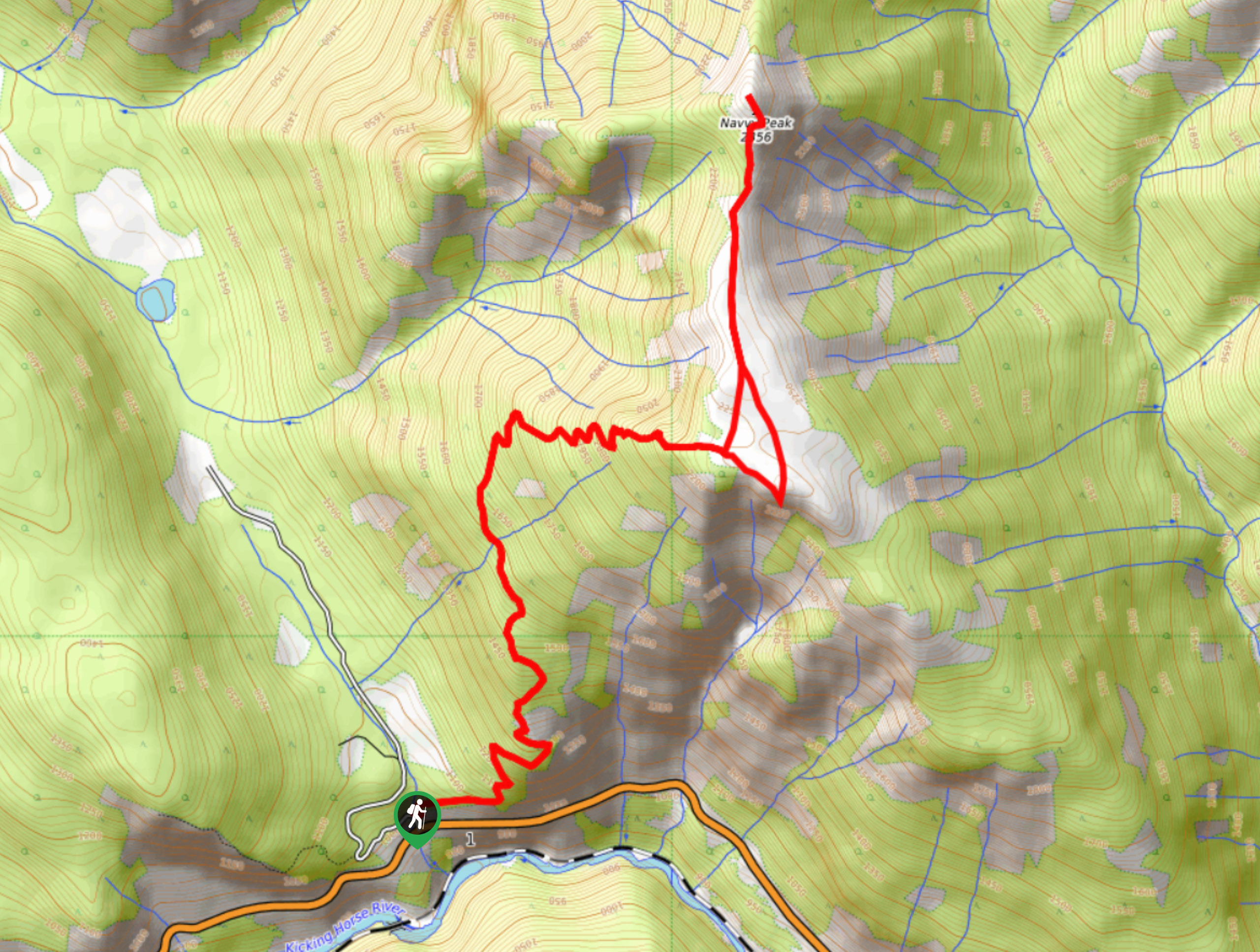
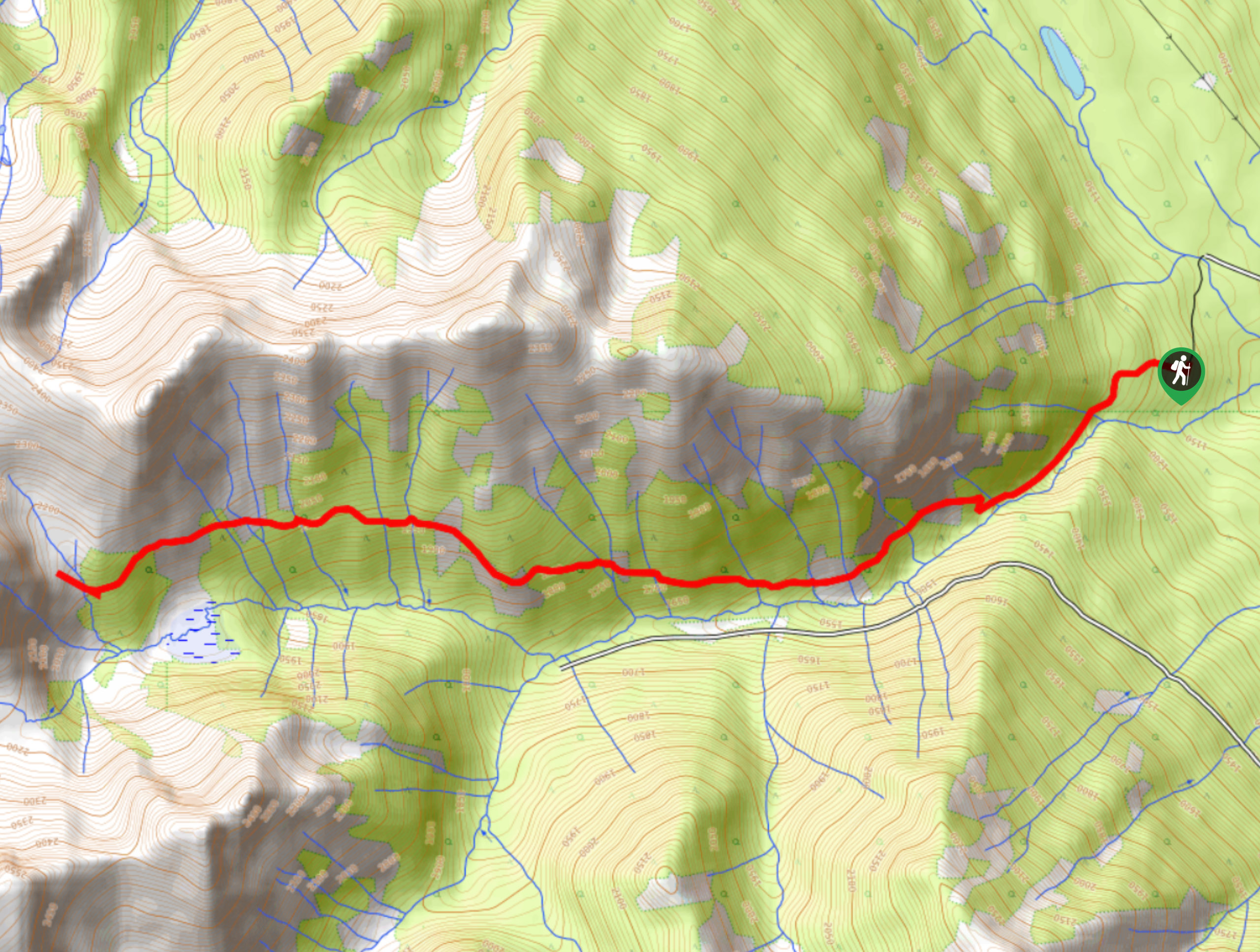
The trail to the summit of Table Mountain and Navvy Peak is a 8.4mi out-and-back route near Golden, BC, that climbs steeply uphill for some fantastic views over the mountainous landscape. The path initially climbs through the forest before breaking into the slightly exposed subalpine terrain on the approach to the summit. Although the route is steep, it’s also straightforward and easy to follow, making for a challenging but rewarding climb up these majestic peaks.
Getting there
To get to the parking area for the hike to Table Mountain and Navvy Peak from Golden, head east on BC-1 for 3.3mi and make a left turn onto Glenogle Creek Road, where you will find the parking area on the left.

About
| When to do | June–September |
| Backcountry Campsites | No |
| Pets allowed | Yes |
| Family friendly | No |
| Route Signage | Average |
| Crowd Levels | Low |
| Route Type | Out and back |
Table Mountain and Navvy Peak
Elevation Graph
Weather
Table Mountain and Navvy Peak Description
It can easily be said that the climb up Table Mountain and Navvy Peak is a grind, with 4767ft of elevation gain packed into the trail; however, the long descent is just as rough on your legs. Make sure to wear proper hiking footwear and bring some hiking poles along to lessen the impact on your knees—they will definitely appreciate it the next day. Additionally, there aren’t any water sources along the hike besides the one at the bottom of the trail, so make sure to bring plenty along to stay hydrated.
Set out from the parking area, where the trail immediately starts to climb sharply uphill through the forest cover toward the first summit of Table Mountain. You will pass through a series of switchbacks along the trail and cross over a few streams before arriving at the viewpoint atop Table Mountain. Take in the sights of Beaverhead Peak and Kapristo Mountain across the valley before continuing to the summit of Navvy Peak. This stretch requires some light scrambling to reach the end of the trail, but you will have an excellent sightline to the top of the peak, making the route easy enough to navigate.
Reaching the summit of Navvy Peak, you will have unreal views of the surrounding mountains, including Mount McBeath and Hedberg Peak to the north, as well as Mount Deville and Mount King to the east. After taking in the views, break out the poles and carefully descend along the steep trail to return to the parking area below.
Similar hikes to the Table Mountain and Navvy Peak hike
Mount 7 Trail
The Mount 7 Trail is a 5.6mi out-and-back hiking route near Golden, BC, that sets out from a…
Upper Certainty Mine Trail
The Upper Certainty Mine Trail is a 1.9mi out-and-back hiking route that will take you through some beautiful…
Lower Certainty Mine Trail
The Lower Certainty Mine Trail is a 6.0mi out-and-back hiking route near Golden, BC, that climbs through the…
Comments